Cymraeg / English

|
Vale of Clwyd Historic Landscape |

|
Character area map |
Historic Landscape Characterisation
The Vale of Clwyd:
Ystrad, Denbigh and Llanrhaeadr-yng-nghinmeirch, Denbighshire
(HLCA 1059)
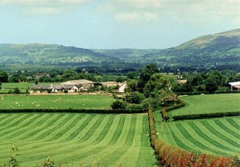
Landscape of scattered large farms and large rectangular fields of pasture on sloping ground, either side of the Afon Ystrad, overlooking the western side of the vale, just to the south of Denbigh.
Historic background
Falling partly within the medieval ecclesiastical parishes of Denbigh and Llanrhaeadr-yng-nghinmeirch, and administratively within the commotes of Is Aled and Ceinmeirch, in the ancient cantref of Rhufoniog.
Key historic landscape characteristics
Sloping land overlooking the western side of the vale to the south of Denbigh, between about 40-100m OD, bisected by the steep-sided wooded gorge of the Afon Ystrad, its river scarps actively eroding in places, with flatter land along the banks of the Ystrad and towards the east and on hill tops to west.Scattered farms, generally 800m or more apart, including the early 18th-century brick farmhouse at Ystrad-isaf, 18th/19th-century limestone and brick farmhouse and outbuildings at Ystrad Farm, Llwyn-bâch, Llwyn-uchaf, and Pen-y-maes, 19th-century brick farmhouse at Brondyffryn Farm, and 20th-century farmhouse and outbuildings at Goblin Farm, the smaller farmhouses in the hills to the west generally looking older. The hall of 19th-century character at Ystrad Hall has been demolished. Small nucleated crossroads settlement with several 18th/19th-century limestone houses, and late 19th-century limestone chapel at Hęn-efail, which as the name suggests grew up around a former smithy.
Medium to large-sized, sloping rectangular pasture fields, with well-maintained low-cut hawthorn field hedges, some of the larger fields being subdivided by post and wire fences. Occasional stone gateposts to fields along public roads.
Roadside hedges on side roads often multiple-species hedges, including holly and hazel, along hollow-ways on steeper slopes.
Land of parkland character extending from the 19th-century brick Brondyffryn School and large late 19th-century house and gardens at Tros-y-parc, opposite Brondyffryn Farm, running down to the northern bank of the Afon Ystrad, by the late 18th or early 19th-century limestone bridge of Pont Felin-ganol, with limestone walling and iron railings on roadside.
Sources
Hubbard 1986Richards 1969
For further information please contact the Clwyd-Powys Archaeological Trust at this address, or link to the Countryside Council for Wales' web site at www.ccw.gov.uk.
Privacy and cookies