Cymraeg / English

|
Clywedog Valley Historic Landscape |

|
Character area map |
|
|
More photographs |
Historic Landscape Characterisation
The Clywedog Valley:
Gorn Hill
Llanidloes and Llanidloes Without communities, Powys
(HLCA 1197)
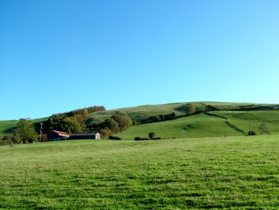
Steeply sloping hill edge south of the Severn valley with widely dispersed farms, woodland plantations of 19th-century origin and mostly regular fieldscapes probably representing enclosure of former upland grazing and former common land in the 18th and 19th centuries.
The area fell within the manorial township of Cilmachallt in the 19th-century Montgomeryshire tithe parish of Llanidloes.
Key historic landscape characteristics
Steeply sloping hill edge to the south and east of the Severn valley overlooking Llanidloes, between a height of 170-320 metres above sea level, dissected by steep-sided stream valleys including the Lletty Cochnant stream. The lower-lying parts of the area are covered with slowly permeable and seasonally waterlogged fine silty and clayey soils derived from mudstone and shales drift deposits, which historically has been best suited to stock rearing and dairying on permanent grassland and cereals in some better-drained areas. The higher parts of the area are covered with well-drained fine loamy or fine silty soils overlying rock, which have historically been best suited to stock rearing, with woodland on steeper slopes. Substantial parts of the higher ground, including Berth-lwyd Coppice were already covered with woodland plantations in the later 19th century, parts of which have since been felled and returned to rough grazing. Areas of sinuous semi-natural broadleaved woodland and scrub survive along some steep-sided stream valleys and on steep slopes elsewhere in the area.Only a small number of placenames are recorded within the area, but it is probably significant that the stream Lletty Cochnant, a tributary of the Severn at Llanidloes, includes the element llety (‘small house, shelter’) indicating the former presence of small and possibly seasonally-occupied dwellings. Few archaeological sites are recorded in the character area, mostly a scattering of small, disused stone quarries which probably provided building for Llanidloes and the surrounding area.
Fieldscapes are characterized by large and small straight-sided fields on the higher ground, probably representing enclosure of former open grazing in the later 18th century onwards, and by small irregular fields on the lower slopes which probably represent a more gradual process of clearance and enclosure from at least medieval times. Parts of the area were subject to parliamentary enclosure in the early 19th century.
Sources
Historic Environment Record; Cadw Listed Building descriptions; modern Ordnance Survey 1:10,000, 1:25,000 mapping and 1st edn Ordnance Survey 1:2,500 mapping; Jones 1983; Richards 1969; Soil Survey of England and Wales; Sothern and Drewett 1991; Thomas 1955-56For further information please contact the Clwyd-Powys Archaeological Trust at this address, or link to the Countryside Council for Wales' web site at www.ccw.gov.uk.
Privacy and cookies