Cymraeg / English

|
Elan Valley Historic Landscape |

|
Character area map |
|
|
More photographs |
Historic Landscape Characterisation
The Elan Valley:
Elan Valley Reservoirs
Llanwrthwl and Rhayader Communities, Powys
(HLCA 1131)
Diverse landscape within, around and below the Victorian and Edwardian reservoir scheme, including dams, reservoirs and ancillary structures, remains of features associated with construction, the flooded landscape in the valley bottoms exposed periodically when the water level is low, together with conifer plantations, remnant natural and semi-natural broadleaved woodland, fields and farms around the valley sides.
Historic background and key historic landscape characteristics
The character area is an amalgam of diverse yet integrated landscape elements, including the relict landscapes both around and below the reservoirs, elements associated with the construction of the reservoirs, the reservoir scheme itself, together with woodland plantings around the reservoir margins. The character area occupies the steep-sided lower valleys of the Elan and Claerwen rivers and the surrounding enclosed land, and lies between about 200ñ450 metres above Ordnance Datum.
There is no clear evidence of the nature of prehistoric settlement and land use in the area, though significant activity is represented by chance finds and by burial and ceremonial sites. Several undated flint flakes have been found on the shoreline of the Craig Goch reservoir, and Bronze Age finds are represented by a dagger or possible halberd found near Glannau Wood, west of the Garreg-ddu reservoir, and by a hoard of late Bronze Age socketed axes found during road-building operations below Caban-coch dam. A dispersed complex of ceremonial sites of perhaps early Bronze Age date on the enclosed upland area west of the Garreg-ddu reservoir comprises a stone alignment and a burial cairn on Rhosygelynnen and a pair of large though now fallen standing stones on Cefn Llanerchi. Other burial cairns are scattered on the upland margin around the valley sides.
The more hospitable and fertile soils of the valley bottom are likely to have been a focus for early woodland clearance and settlement in the period between the early prehistoric and early medieval periods. The character area formed part of the lands in the commote of Deuddwr granted to by Rhys ap Gruffydd to the Cistercian abbey at Strata Florida in 1184, the grange being commemorated in the place-names Dol-y-mynach (ëMonkís Meadowí) and Craig Mynach (ëMonkís cliffí) near the Dolymynach reservoir. The abbey may have farmed some of the land itself, though much of the revenue from the land was probably obtained from the farms and smallholdings leased to individual tenants. Early settlement evidence is suggested by a number of platform sites which probably represent the site of timber buildings which have now disappeared. Characteristic of buildings of the later Middle Ages is the cruck-framed longhouse at Llannnerch-y-cawr, of late 14th to early 15th century date, with accommodation for humans and animals beneath the same roof.
The dissolution of Strata Florida abbey in 1539 saw much of the enclosed land on the valley bottom and valley sides being sold off and the emergence of many of the farms that are later known dotted along the valley bottom and on the valley sides. The later 16th to 18th centuries saw the growth of a number of landed estates within the valley, most notably those based upon what were to became the small and fashionable country houses at Nantgwyllt and Cwm Elan in the later 18th and early 19th centuries, both associated with small parks and gardens which were both briefly to become associated with the poet Percy Bysshe Shelley in the second decade of the 19th century, drawn to the picturesque landscapes of the Elan valley.
The larger houses at Nantgwyllt and Cwm Elan formed part of a broader landscape of dispersed stone-built farmsteads, perhaps characterized by the 18th-century farmhouse with attached cowhouse at Cwm Clyd set within a fieldscape of small irregular fields. Building materials were obtained from a number of small scattered quarries, such as those on southern end of Craig Mynach, on the edge of Moelfryn, and near Henfron farm. A number of these farms and smallholdings had probably been already abandoned before construction work began on the Elan valley reservoirs in the last decade of the 19th century, evident from the now ruinous farm houses and farm buildings at Yr Allt and Pant, respectively to the north and east of Marchnant farm, at Pen-cae-haidd, Llanerchi and Blaen-coel and elsewhere on the marginal land around the margins of the reservoirs due as a result of rural depopulation and the amalgamation of holdings.
The reservoir scheme built for the corporation of Birmingham built between 1893 and 1906 was superimposed upon these earlier landscapes and involved the demolition and flooding of about thirty buildings. The foundations of a number of these buildings, including Nantgwyllt house and its walled garden and Garreg-ddu house below the Caban-coch reservoir, Cwm Elan house and Dol-faenog house below the Garreg-ddu reservoir, and Ty-nant house below the Penygarreg reservoir, together with roads, tracks, bridges, field boundaries are periodically exposed when the water levels fall within the reservoirs.
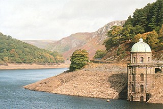
The original reservoir scheme which allowed for some expansion envisaged seven reservoirs, of which four ó Caban-coch, Garreg-ddu, Penygarreg and Graig Goch ó were fully completed and one, Dolymynach, partly completed. The engineering architecture which embraces the major structures such as dams and valve towers, as well as more minor features such as parapets, culverts were built in rock-faced masonry in a distinctive civic style which has become popularly known as ëBirmingham Baroqueí which has a unifying effect upon the widespread elements of the scheme. Various aspects of the scheme were designed to contribute to the stunningly picturesque natural landscape, consciously creating views and visual effects that would enthral generations of visitors. This was further enhanced by lakeside woodland plantings which likewise had a practical as well as ornamental purpose, which blends in with the remnant ancient broadleaved woodland surviving around some of the valley sides. Particular attention was given to the confluence of the Elan and Claerwen valleys, the focal point of the scheme, which includes the Foel tower where the water drawn off for Birmingham begins its journey, the deceptive Garreg-ddu viaduct which creates the illusion of crossing a shallow lake, and the gothic Nantgwyllt church which replaced the chapel submerged below the adjacent reservoir.
Construction works were clearly designed to have a limited impact upon the landscape, though some important features remain, including the Cigfran quarry above the Caban-coch dam, the former railway lines visible below Dolfaenog and along the north bank of the Penygarreg reservoir, including the brick bridge across the Nant Hesgog just to the west of the Penygarreg dam, and the deep cutting known as the ëDevilís Gulchí through edge Craig yr Allt-goch. Many of the other working areas were to be submerged as the waters of the reservoirs rose, though some element are exposed when the water level drops, including for example the masonsí yard to the eastern shore of Caban-coch reservoir and the foundations of a workmenís hut near Craig Goch dam.
Sources
Abse 2000; Anon 1813; Bidgood 1995, 1996; Fenn, Fenn & Sinclair 2002; Fenn & Sinclair 2003; Hawkins 1985; Hubbard 1979; Jones & Smith 1963; Judge 1997; Lloyd 1989; Mansergh 1894; Miles & Worthington 1999; Newman 1960; Nicholson 1813; Owens 2000; Rosetti 1894; Savory 1980; P. Smith 1963, 1975; Tickell 1894; D. H. Williams 1999, 2001; Listed Buildings lists; Regional Sites and Monuments Record.
For further information please contact the Clwyd-Powys Archaeological Trust at this address, or link to the Countryside Council for Wales' web site at www.ccw.gov.uk.
Privacy and cookies