Cymraeg / English

|
Elan Valley Historic Landscape |

|
Character area map |
|
|
More photographs |
Historic Landscape Characterisation
The Elan Valley:
Cwm Elan Mine
Rhayader Community, Powys
(HLCA 1134)
Compact and well-preserved former lead and zinc mining landscape, principally of the late 19th century, with traces of earlier mining remains.
Historic background and key historic landscape characteristics
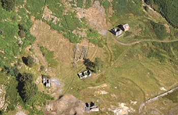
The Cwm Elan mine lies in a remote site on the western slopes of the Nant Methan valley, at the head of an upland valley, 1 kilometre west of the Garreg-ddu Reservoir, at a height of between about 290-380m. The surviving remains of the mine, which produced which produced lead and zinc ores, present a compact mining landscape, the site being surrounded by steep valley slopes as well as being constrained by the geology. The majority of the surviving remains belong to a single phase of operation, and provide what is perhaps the best example of late 19th-century mining technology and planning in Powys, with the structures still remarkably well preserved. Earlier working and processing was initially undertaken by the landowner, the Groves of Cwm Elan, before it was leased it to a firm headed by Sir Thomas Bonsall. Operations were later taken over by a Cornish company before working was temporarily abandoned. The main phase of working began in 1871 with the formation of the Cwm Elan Mining Company. Two main lodes were explored, and by November 1872 workings included shallow and deep adits as well as a 10 fathom level. In April 1873 a processing mill began operations, including a Blake’s stonebreaker, crushing rolls, Collom’s patent jiggers and round buddles, all of which were supplied by William Thomas of Llanidloes Foundry. Power was supplied by three waterwheels, the largest of which was 36 feet by 4 feet, fed by water running in a leat which ran for nine miles from Llyn Cerrig-llwydion towards the western side of the Elenydd moorland. Workings had extended to the 20 fathom level by 1874, but a drought and lack of funds forced the company into voluntary liquidation. Work restarted the following year as New Cwm Elan Mine, with the shaft eventually being extended to the 40 fathom level when work finally ceased in 1877.
Most of the visible remains date to the later 19th century, though earlier workings may be represented by a series of shallow open-cuts along the banks of the stream, and early processing is possibly represented by two building platforms with surrounding waste tips. Visible remains include the partially collapsed shafts and levels and drainage adits, a wheel pit, bob-pit, a stone quarry which presumably provided stone for the mine buildings, the remains of which include an explosive’s magazine, a single storey smithy, crusher house, a manager’s house and office. To the east is a red brick house built in the 1890s by the Birmingham Corporation to house estate workers, after they had acquired the Elan Estate to construct the existing reservoirs. There is no indication of any workers’ accommodation and it is possible that the workforce travelled to the site each day from the valley below, any evidence for which has been lost beneath the reservoirs. Ore was stored in a bank of three ore-bins, surviving remains of ore processing including stone revetted platforms for jiggers and a circular buddle and settling pits. Other mining remains include leats, culverts, a water reservoir, building platforms and a boundary bank.
Sources
Hall 1993; Hawkins 1985; Jones, Walters & Frost forthcoming; Welsh Water (undated), Regional Sites and Monuments Record
For further information please contact the Clwyd-Powys Archaeological Trust at this address, or link to the Countryside Council for Wales' web site at www.ccw.gov.uk.
Privacy and cookies