|
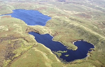 The two upland lakes called Llyn Fyrddon Fach (in the foreground) and Llyn Fyrddon Fawr, at a height of about 530 metres on the western side of Elenydd upland. Llyn Fyrddon Fawr is one of the upland lakes in the area which is said to have supplied eels and trout to the medieval Cistercian monastery at Strata Florida, about 7 kilometres as the crow flies, to the south-west.
Photo: CPAT 03-c-0653.
The two upland lakes called Llyn Fyrddon Fach (in the foreground) and Llyn Fyrddon Fawr, at a height of about 530 metres on the western side of Elenydd upland. Llyn Fyrddon Fawr is one of the upland lakes in the area which is said to have supplied eels and trout to the medieval Cistercian monastery at Strata Florida, about 7 kilometres as the crow flies, to the south-west.
Photo: CPAT 03-c-0653.
|
|
|

|
|
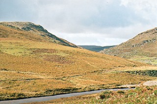 Part of the Claerwen valley, with the river in the foreground. In the background is the valley of the Afon Arban, looking towards Crug Gynon on the far horizon.
Photo: CPAT 1526.32.
Part of the Claerwen valley, with the river in the foreground. In the background is the valley of the Afon Arban, looking towards Crug Gynon on the far horizon.
Photo: CPAT 1526.32.
|
|
|
|
|
|
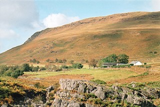 The small upland farm at Ciloerwynt in the Claerwen valley, with Graig Fawr beyond, is characteristic of a number of encroachments on the Elenydd moorland. The modern farmhouse replaces the stone-built longhouse which was moved to the Museum of Welsh Life in 1955. The longhouse began life as a timber cruck-built building dating to about 1476 and first referred to in documents of 1568.
Photo: CPAT 1527.02.
The small upland farm at Ciloerwynt in the Claerwen valley, with Graig Fawr beyond, is characteristic of a number of encroachments on the Elenydd moorland. The modern farmhouse replaces the stone-built longhouse which was moved to the Museum of Welsh Life in 1955. The longhouse began life as a timber cruck-built building dating to about 1476 and first referred to in documents of 1568.
Photo: CPAT 1527.02.
|
|
|
|
|
|
 Stone-walled enclosure and remains of longhouse at Lluest-pen-rhiw, on the eastern edge of the moorland, above Nannerth. The encroachment is associated with areas of narrow ridge and furrow.
Photo: CPAT 03-c-0587.
Stone-walled enclosure and remains of longhouse at Lluest-pen-rhiw, on the eastern edge of the moorland, above Nannerth. The encroachment is associated with areas of narrow ridge and furrow.
Photo: CPAT 03-c-0587.
|
|
|
|
|
|
 The ruins of the farmhouse and outbuildings at Lluest-aber-caethon, to the west of Craig Goch dam. According to a datestone in the chimney, the house was built in 1814, but the encroachment on the moorland might have originated much earlier. An oval earthwork enclosure of unknown date is visible towards the bottom right.
Photo: CPAT 03-c-0632.
The ruins of the farmhouse and outbuildings at Lluest-aber-caethon, to the west of Craig Goch dam. According to a datestone in the chimney, the house was built in 1814, but the encroachment on the moorland might have originated much earlier. An oval earthwork enclosure of unknown date is visible towards the bottom right.
Photo: CPAT 03-c-0632.
|
|
|
|
|
|
 Pillow mounds and narrow ridge and furrow on the lower slopes of Esgair y Ty. In the background are the former turnpike road across the moorland between Rhayader and Aberystwyth and the distinctive but unusual meanders of the upper reaches of the river Elan which probably owe their origin to the late glacial period.
Photo: CPAT 03-c-0640.
Pillow mounds and narrow ridge and furrow on the lower slopes of Esgair y Ty. In the background are the former turnpike road across the moorland between Rhayader and Aberystwyth and the distinctive but unusual meanders of the upper reaches of the river Elan which probably owe their origin to the late glacial period.
Photo: CPAT 03-c-0640.
|
|
|
|
|
