Cymraeg / English

|
Elan Valley Historic Landscape |

|
Character area map |
|
|
More photographs |
Historic Landscape Characterisation
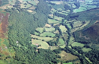
The Elan Valley:
Cwm Dulas
Llanwrthwl and Rhayader Communities, Powys
(HLCA 1137)
Landscape of dispersed farms and small irregular fields of medieval and later origin in upland valley between Carn Gafallt and the Elenydd uplands, with indications of much earlier, prehistoric activity.
Historic background and key historic landscape characteristics
Upland valley lying between Carn Gafallt to the north and part of the Elenydd uplands to the south. The valley bottom, between about 200-300 metres above Ordnance Datum rises steeply to meet the surrounding upland at a height of about 400 metres. The sides of the valley are cloaked in ancient natural and semi-natural oak woodland, such as Allt Ddu, Talwrn Wood, Coed Cefngafallt and Crwnallt, with some hazel groves towards the valley bottom.
Although no early settlements have yet been identified, early activity is suggested by a number of high-status finds of middle Bronze Age jewellery, including a penannular gold ring found near Talwrn farm and a hoard of four gold torcs found to the east of Cae-haidd farm, which may imply that some farming establishments had been established by at least 1500 BC.
The present-day landscape of dispersed small farms and smallholdings is likely to be predominantly of medieval and early post-medieval origin. Medieval settlement is suggested by a number of abandoned platforms which were once superimposed by timber buildings which have now disappeared. An early building horizon is suggested by the farmhouse at Talwrn which evidently began life as a timber, cruck-built longhouse of perhaps late 15th to early 16th-century date, partly rebuilt in stone in the later 17th century. A number of the existing farms such as Cefn, Crownant (Crawnant) and Blaen-y-cwm are known to have been in existence by the 16th and early 17th centuries but may have earlier origins, characterized by small farm complexes with stone farmhouses and outbuildings, some originally of longhouse form, with accommodation for people and animals under the same roof. Characteristic farm buildings include small 18th and 19th-century hay or threshing barns with ventilation slits.
The fieldscape associated with these farms is characterized by small irregular fields extending onto the steep valley sides, many of which have evidently been created by clearance of native broadleaved woodland along the valley sides, many bounded by multi-species hedges. A small number of fields have boundaries defined by drystone walls. The predominant land use today is for pasture, but the evidence of lynchet formation and place-names such as Cae-haidd (‘Barley Field’) indicate that cultivation was more widespread in the past. Rural depopulation in the 19th and 20th centuries is represented by a number of abandoned cottages and houses which now lie in ruins. Some areas of former ancient fields, such as those near The Clyn, were overplanted with conifers in the 20th century. Some poorly drained land along the valley bottom.
Sources
Bidgood 1995; Jones & Smith 1963; T. Jones 1909-30; Savory 1958, 1980; Smith 1975; Regional Sites and Monuments Record
For further information please contact the Clwyd-Powys Archaeological Trust at this address, or link to the Countryside Council for Wales' web site at www.ccw.gov.uk.
Privacy and cookies