
Cymraeg / English
|

|
Historic Landscape Characterisation
East Fforest Fawr and Mynydd-y-glôg:
Garreg-fawr
Photographs of character area
|
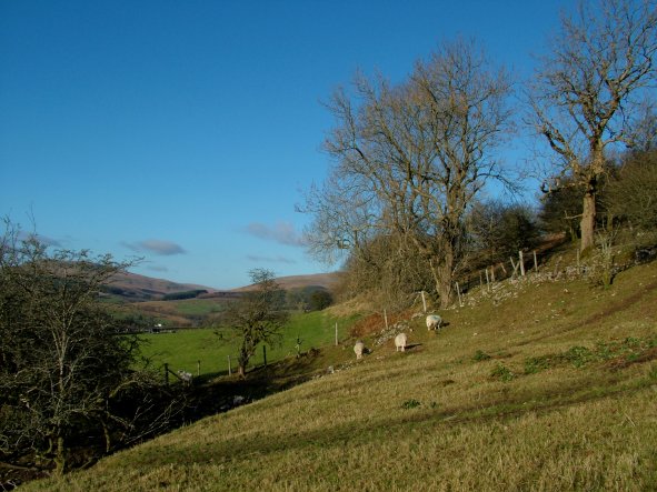 Enclosed fields of possibly later medieval and early post-medieval date defined by clearance banks and modern post-and-wire fences on the upper, eastern flanks of the Mellte valley, below Gwaun Cefnygarreg, looking northwards.
Photo: CPAT 2509-106.
Enclosed fields of possibly later medieval and early post-medieval date defined by clearance banks and modern post-and-wire fences on the upper, eastern flanks of the Mellte valley, below Gwaun Cefnygarreg, looking northwards.
Photo: CPAT 2509-106.
|
|
|
|
|
|
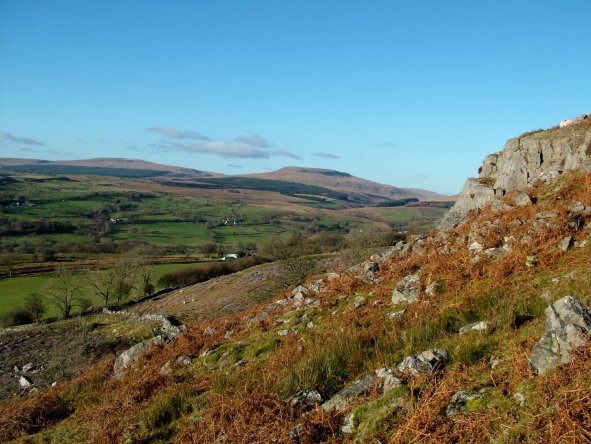 Drystone wall of probably later 18th- to earlier 19th-century date along the boundary of the fields on the upper, eastern flanks of the Mellte valley and the enclosed upland pastures on Gwaun Cefnygarreg, with an area of recently-felled conifer woodland in the left foreground.
Photo: CPAT 2509-111.
Drystone wall of probably later 18th- to earlier 19th-century date along the boundary of the fields on the upper, eastern flanks of the Mellte valley and the enclosed upland pastures on Gwaun Cefnygarreg, with an area of recently-felled conifer woodland in the left foreground.
Photo: CPAT 2509-111.
|
|
|
|
|
|
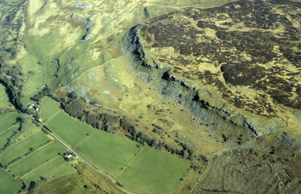
 Aerial view of fields and farms dating from the later medieval and early post-medieval period at Pen-fathor, high on the western margins of the Mellte valley, with the unenclosed moorland of Mynydd y Garn beyond, viewed from the west. Some of the farms and field boundaries are shown on an estate map of the Hon. George Venables Vernon, dated 1776. The streams to the left are tributaries of the Afon Dringarth, at the head of which is the Ystradfellte Reservoir, built as a water supply for Neath between 1907 and 1914. The trackway running between the two farms in the middle distance lies on the course of the now-disused railway which supplied building materials during the construction of the reservoir.
Photo: CPAT 08-C-19.
Aerial view of fields and farms dating from the later medieval and early post-medieval period at Pen-fathor, high on the western margins of the Mellte valley, with the unenclosed moorland of Mynydd y Garn beyond, viewed from the west. Some of the farms and field boundaries are shown on an estate map of the Hon. George Venables Vernon, dated 1776. The streams to the left are tributaries of the Afon Dringarth, at the head of which is the Ystradfellte Reservoir, built as a water supply for Neath between 1907 and 1914. The trackway running between the two farms in the middle distance lies on the course of the now-disused railway which supplied building materials during the construction of the reservoir.
Photo: CPAT 08-C-19.
|
|
|
|
|
|
 Fields near Garreg-fawr Farm, to the left, on the northern edge of the Mellte valley, viewed from the south-west, with the steep scarp and screes along the western edge of the sandstone outcrop of Gwaun Cefnygarreg in right background. A cluster of small quarries and limekilns probably of late 18th- or early 19th-century date are just visible on the hillslope behind Garreg-fawr farm.
Photo: CPAT 08-C-26.
Fields near Garreg-fawr Farm, to the left, on the northern edge of the Mellte valley, viewed from the south-west, with the steep scarp and screes along the western edge of the sandstone outcrop of Gwaun Cefnygarreg in right background. A cluster of small quarries and limekilns probably of late 18th- or early 19th-century date are just visible on the hillslope behind Garreg-fawr farm.
Photo: CPAT 08-C-26.
|
|
|
|
|
|
