|
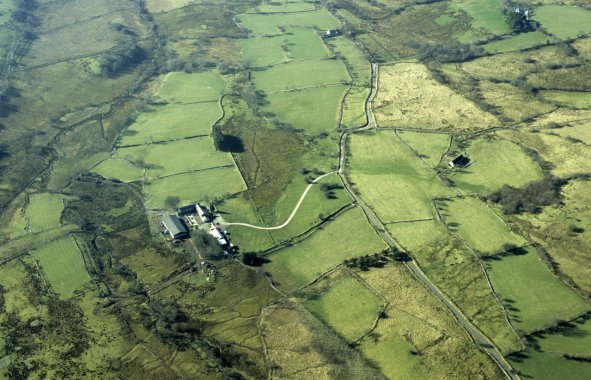 Aerial view of farms and fields towards the head of the Cwm Cadlan, near Wernlas and Esgair-y-gadlan, viewed from the east. Many of the smaller irregular fields are of ancient origin but some reorganisation of field boundaries during the 19th century is suggested by the more regular pattern of fields beyond Wernlas farm, visible in the left foreground, which itself appears to have been built or remodelled at that date. The barn at Esgair-y-gadlan, in the right middle distance, is probably all that survives of a former farmstead that had already been abandoned by the 1880s, possibly due to farm amalgamations.
Photo: CPAT 08-C-55.
Aerial view of farms and fields towards the head of the Cwm Cadlan, near Wernlas and Esgair-y-gadlan, viewed from the east. Many of the smaller irregular fields are of ancient origin but some reorganisation of field boundaries during the 19th century is suggested by the more regular pattern of fields beyond Wernlas farm, visible in the left foreground, which itself appears to have been built or remodelled at that date. The barn at Esgair-y-gadlan, in the right middle distance, is probably all that survives of a former farmstead that had already been abandoned by the 1880s, possibly due to farm amalgamations.
Photo: CPAT 08-C-55.
|

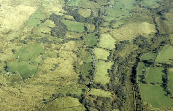
 Small irregular fields of probably medieval or earlier origin near Esgair-y-gadlan defined by now dilapidated drystone walls, looking north-westwards towards the unenclosed moorland of Cefn Cadlan on the horizon. The probably 19th-century barn in the middle distance is all that survives of a former farm complex.
Photo: CPAT 2509-45.
Small irregular fields of probably medieval or earlier origin near Esgair-y-gadlan defined by now dilapidated drystone walls, looking north-westwards towards the unenclosed moorland of Cefn Cadlan on the horizon. The probably 19th-century barn in the middle distance is all that survives of a former farm complex.
Photo: CPAT 2509-45.
 Damp lowland meadows with irregular boundaries defined by hedges of probably medieval or earlier origin bordering the Nant Cadlan stream, looking south-eastwards towards Mynydd-y-glog on the horizon. Landscape reorganisation in the later 18th to earlier 19th century is suggested by the pattern of straighter-sided fields around Garw-dyle farm in the middle distance.
Photo: CPAT 2509-120.
Damp lowland meadows with irregular boundaries defined by hedges of probably medieval or earlier origin bordering the Nant Cadlan stream, looking south-eastwards towards Mynydd-y-glog on the horizon. Landscape reorganisation in the later 18th to earlier 19th century is suggested by the pattern of straighter-sided fields around Garw-dyle farm in the middle distance.
Photo: CPAT 2509-120.
 Aerial view of ancient irregular fields in Cwm Cadlan with the abandoned farmstead of Gwern-pawl visible on the extreme left.
Photo: CPAT 08-C-52.
Aerial view of ancient irregular fields in Cwm Cadlan with the abandoned farmstead of Gwern-pawl visible on the extreme left.
Photo: CPAT 08-C-52.