Cymraeg / English

|
Mynydd Hiraethog Historic Landscape |

|
Character area map |
Historic Landscape Characterisation
Mynydd Hiraethog:
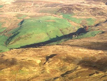
Ffrithuchaf
Llangernyw, Conwy
(HLCA 1100)
Unenclosed moorland on the northern edge of Mynydd Hiraethog, overlooking Gwytherin and the steep-sided valley of the Afon Cledwen.
Historic background
Early activity is represented by the two Bronze Age cairns on Carnedd Cronwy, on a ridge above the edge of the Afon Cledwen valley. The area fell within the 19th-century tithe parish of Gwytherin. Relatively little archaeological fieldwork has been undertaken in the area within recent years and few archaeological sites are recorded in the area.
Key historic landscape characteristics
The character area occupies an area of just over 3km2 of undulating heather moorland on the western edge of Mynydd Hiraethog, between a height of about 360-400m above Ordnance Datum. It includes the southern slopes of Moel Maelogen and Ffriddog and faces predominantly to the north and east, overlooking the Afon Cledwen valley. The area is drained by eastward flowing streams which feed the Afon Cledwen, a tributary of Afon Elwy.
No evidence of settlement is recorded in the area. The present boundary between the moorland and the lower-lying enclosed ground are essentially those shown on the Gwytherin tithe map of 1842, in places marked by a large earthen bank and ditch representing piecemeal enclosure by the lower-lying farms within the valley of the Afon Cledwen, probably from the medieval period onwards. In places these earlier boundaries have been abandoned and lie isolated within the moorland, having been replaced by post-and-wire fences, sometimes lower down the hill. The area is crossed by the winding mountain lane linking Nebo and Gwytherin, possibly of medieval origin, but again first recorded together with several other lanes and footpaths on the Gwytherin tithe map giving access to the upland pasture from the lower-lying farms. A series of marker stones at about 400m intervals along the southern boundary of the character area, erected in probably the later 18th or earlier 19th century, mark the boundary between the 19th-century tithe parishes of Gwytherin and Tiryrabad-isaf (Pentrefoelas).
Sources
CPAT Sites and Monuments Record;
Gwytherin tithe map and apportionment
For further information please contact the Clwyd-Powys Archaeological Trust at this address, or link to the Countryside Council for Wales' web site at www.ccw.gov.uk.
Privacy and cookies