Cymraeg / English

|
Mynydd Hiraethog Historic Landscape |

|
Character area map |
Historic Landscape Characterisation
Mynydd Hiraethog:
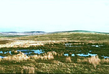
Fawnog-fawr
Bro Garmon, Gwynedd
(HLCA 1101)
Moorland on western edge of Mynydd Hiraethog, subdivided into large polygonal enclosures in the late 18th to early 19th century.
Historic background
The area falls within the 19th-century tithe parish of Llanrwst. Relatively little recent archaeological fieldwork has been undertaken within the area and relatively few archaeological sites are recorded.
Key historic landscape characteristics
The character area occupies an area of over 5km2 of predominantly west-facing undulating moorland on the western edge of Mynydd Hiraethog, between a height of about 270-470m above Ordnance Datum, and includes the summits of Foelasfechan, Moel Seisiog, Bron Alarch and Cefn Rhudd. Drainage is to the north by the Derfyn and Cledwyn, tributaries of the Afon Elwy, and to the west by the Sychnant, Cyffdy, Iwrch, Cerrig-nadd, tributaries of the Conwy.
There is no evidence of settlement within the area at any period. The present boundaries between the moorland and the lower-lying enclosed ground are essentially those shown on the Llanrwst tithe map of 1836, some being formed of drystone walling and some by post-and-wire fences. Boundaries dividing the moorland area into large polygonal enclosures, probably of late 18th- or early 19th-century origin, are generally formed of post-and-wire fences, the only other evidence of agricultural activity in the area being represented by a number of sheepfolds along the margins of the moorland. The area is crossed by a number of footpaths and tracks providing access to the moorland from lower-lying farms near Nebo, some of which are likely to be considerable antiquity. Some of the tracks, such as those from Nebo leading to Bryn-cyplau and the western side of Moel Seisiog, gave access to areas of peat-digging, some of which were evidently being worked from the mid 19th to the mid 20th century, and probably earlier. Former peat cuttings on Fawnog-fawr itself now form shallow pools. Surviving peat deposits are of potential importance to the environmental history of the western Mynydd Hiraethog. and farms along the eastern side of the Conwy valley.
Sources
CPAT Sites and Monuments Record;
Llanrwst tithe map and apportionment
For further information please contact the Clwyd-Powys Archaeological Trust at this address, or link to the Countryside Council for Wales' web site at www.ccw.gov.uk.
Privacy and cookies