Cymraeg / English

|
Mynydd Hiraethog Historic Landscape |

|
Character area map |
Historic Landscape Characterisation
Mynydd Hiraethog:
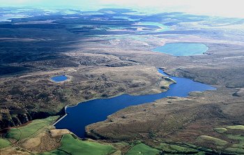
Aled Isaf Reservoir
Llansannan, Conwy
(HLCA 1103)
Modern reservoir fed by the Afon Aled in valley on northern edge of Mynydd Hiraethog.
Historic background
The area falls within the 19th-century tithe parish of Llansannan which formed relatively barren moorland until the construction of the reservoir in the earlier 20th century, resulting in little more than the minor diversion of the minor road running along its eastern shore and the submerging of a former sheepfold, ford and stepping stones.
Key historic landscape characteristics
Reservoir completed in 1938, about 1.3km from end to end and about 200m wide, covering an area of almost 0.3km2, with tall concrete dam above the Rhaeadr y Bedd waterfalls on the Afon Aled. at a height of about 360m above Ordnance Datum on the northern edge of Mynydd Hiraethog. The area looks predominantly to the north. Drainage is also to the north, and feeds the Afon Elwy river system.
Early settlement activity of a seasonal or permanent nature is indicated by scatters of lithic material of Mesolithic to Bronze Ag date found in areas of eroding soil around the reservoir margins during periods of low water in the 1970s and 1980s.
Curved dam of concrete blocks with plain concrete valve tower carrying minor road.
Sources
CPAT Sites and Monuments Record;
Brassil 1989;
Hollett 2000.
For further information please contact the Clwyd-Powys Archaeological Trust at this address, or link to the Countryside Council for Wales' web site at www.ccw.gov.uk.
Privacy and cookies