Cymraeg / English

|
Mynydd Hiraethog Historic Landscape |

|
Character area map |
Historic Landscape Characterisation
Mynydd Hiraethog:
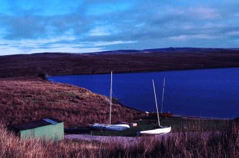
Llyn Aled
Llansannan, Conwy
(HLCA 1104)
Natural upland lake extended as reservoir in the earlier 20th century within the central moorland area of Mynydd Hiraethog.
Historic background
The area falls within the 19th-century tithe parishes of Llansannan and Henllan. The lake is first described by Thomas Pennant in the 1780s as 'small lake from which the river flows . . . amidst black and heathy mountains'.
Key historic landscape characteristics
The reservoir covers an area of about 0.4km2 at a height of about 370m above Ordnance Datum, generally enclosed by higher ground but open to the north. The stone and earth dam at the northern end of the lake which also carries a minor road across the moor, was built in 1934, together with a low rock-faced valve tower. The lake lies at the head of the Afon Aled which feeds the Afon Elwy river system. Ancient waterlogged sediments at the base of the lake are of potential significance to the environmental and land use history of Mynydd Hiraethog. Today the lake is used for both recreational sailing and fishing. The boat club on the northern side of the lake has replaced farmstead of Ty'n-y-llyn shown on the tithe map of 1841. A boathouse and flagstaff had been established here by the 1870s.
Sources
CPAT Sites and Monuments Record;
Pennant 1783;
Hollett 2000.
For further information please contact the Clwyd-Powys Archaeological Trust at this address, or link to the Countryside Council for Wales' web site at www.ccw.gov.uk.
Privacy and cookies