Cymraeg / English

|
Mynydd Hiraethog Historic Landscape |

|
Character area map |
Historic Landscape Characterisation
Mynydd Hiraethog:
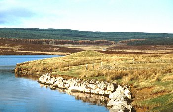
Bryn-y-gors-goch
Nantglyn Community, Denbighshire and Cerrigydrudion Community, Conwy
(HLCA 1110)
Modern coniferous forest plantation overlying relict medieval and later enclosed landscape of scattered farmsteads with associated field systems and stone quarrying.
Historic background
The area falls within the 19th-century tithe parishes of Nantglyn, Henllan and Cerrigydrudion. Some archaeological fieldwork was undertaken within the Forest Enterprise holdings in the 1990s.
Key historic landscape characteristics
The character area occupies an afforested area of about 14km2 on the south and east-facing slopes north of the Alwen Reservoir and west of the Brenig Reservoir, towards the eastern side of Mynydd Hiraethog, at a height of between 360-510m above Ordnance Datum. The Nant Bryn-y-gors-goch, Brenig and Afon Fechan streams feed the Afon Alwen to the south, a tributuary of the Dee river system. At the northern end of the area is the small natural lake of Llyn Bran, surrounded by woodland, slightly enlarged following the construction of a dam at its northern end. The area is now largely covered by the modern coniferous forestry, some on ploughed ridges, dating mainly from the 1930s, subdivided into different parcels by roads and rides, though smaller areas of conifer and mixed conifer and decidous woodland on the southern margins of the character area were already in existence by the earlier 19th century, with other plantations evidently actively being planted during the later 19th century.
Little evidence of early settlement in the area has been identified though early activity in the area is suggested by the the presence of early Bronze Age burial mounds on Gorsedd Bran and by the discovery of a Late Bronze Age rapier found in a peat bog on the slopes of Craig-hir, overlooking the Brenig valley. Medieval and later settlement is represented by a scatter of small farmsteads and smallholdings occupying the south-facing slopes overlooking the Afon Alwen, towards the southern end of the area, at a height of between about 370-400m whose fields and buildings are now mostly abandoned and either engulfed by the Alwen coniferous plantation or submerged below the Alwen Reservoir bordering the southern edge of the character area. A number of the farms, notably Hafod-y-llan-isaf and -uchaf, contain the element hafod 'summer house' suggesting that they began life as seasonally-occupied dwellings each connected with a hendre or all-year-round settlement on lower ground. Documentary evidence indicates that permanent farms with associated fields had been established in a number of instances by a least the middle of the 16th century. A number of the cottage, including Hafod-y-llan-bach belong to the later 19th century.
Most of the dwellings and associated outbuildings have been abandoned and are now in ruins, as in the case of the 18th/19th-century buildings at Ty-isaf and Ty-uchaf, though some like Hafod-y-llan-uchaf are still maintained whilst Hafod-y-llan-isaf is still occupied. Field boundaries shown on earlier maps of the area can be traced as banks and dilapidated walls within the forestry. The farmhouses were typically single-storey stone-built structures with small stone or brick outbuildings, the farmstead at Ty-isaf including a now ruinous cowhouse and byre.
Stone quarrying especially for slate slabs was being carried out within a number of reasonably extensive though relatively small commercially-operated quarries in the northern part of the area in the 19th and early 20th centuries, on the southern side of Gorsedd Bran and now partly hidden by the forestry. Production, mainly involving hand-sawing but possibly some power sand-sawing at Aber, continued until the 1920s in the case of the Aber quarry and the 1950s in the case of the Nantglyn quarry. Small-scale quarrying for farm buildings and field walls from the late medieval or early post-medieval periods onwards are to be found in the vicinity of a number of the former farmsteads in the southern part of the area, as in the vicinity of Ty-isaf and Ty-uchaf.
Much of the road system running northwards from Cerrigydrudion through the forestry dates from the construction of the Llyn Brenig reservoir in the 1970s.
The area includes a number waterlogged and peaty deposits which are of potential significance to an understanding of the environmental and land use history of the area.
Sources
CPAT Sites and Monuments Record;
CAP 1998;
Davies 1977;
Jones 1966;
Richards 1991
For further information please contact the Clwyd-Powys Archaeological Trust at this address, or link to the Countryside Council for Wales' web site at www.ccw.gov.uk.
Privacy and cookies