Cymraeg / English

|
Vale of Llangollen Historic Landscape |

|
Character area map |
|
|
More photographs |
Historic Landscape Characterisation
The Vale of Llangollen:
Dol-isaf
Llangollen Community, Denbighshire, and Llangollen Rural Community, Wrexham
(HLCA 1153)
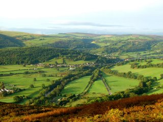
Visually outstanding valley floor of the steep-sided Dee valley between Llangollen and Pontcysyllte, with fieldscapes, golf-course and prominent gardens and parkland areas.
Historic background
The discovery of a number of early finds in the area, including fragments of a Neolithic stone axes near Ty’n Celyn and Trevor Hall, and a Roman brooch again near Trevor Hall are probably indicative of early settlement and land use in the Vale, which is perhaps unsurprising in view of the rich agricultural land to be found here. Anciently, the area fell within the native kingdom of Powys and subsequently, from the late 12th century formed parts of the commotes of Nanheudwy principally to the south of the Dee and Maelor Gymraeg to the north of the Dee in the subdivided northern portion of the kingdom known as Powys Fadog. Following the Edwardian conquest in the late 13th century most of the area to the north of the river came to form part of the marcher lordship of Bromfield and Yale and the area to the south of the river part of the marcher lordship of Chirk. Historically, much of the land in the valley has been in the ownership of a small number of prominent estates since perhaps before the 11th century associated with ancient families including the Mostyn family associated with Pengwern and the Trevor family associated with Trevor Hall. Though poorly documented, monastic granges belonging to Valle Crucis Abbey have been thought to have existed at both Pengwern Hall and in the vicinity of Trevor Mill. A number of other large houses, notably Argoed Hall, Tyn-dwr, and Bryn Howell were the creation of local industrialists during the second half of the 19th century.
Key historic landscape characteristics
The character area constitutes the valley floor and lower-lying ground on the valley sides of the meandering river Dee to the east of Llangollen, between a height of about 100–200 metres above sea level and including ancient river terraces and cut-offs. For convenience of defining character areas it also includes Pengwern Vale, a relict meander of the Dee and the isolated intervening Pen-y-coed hill to the east of Llangollen. Present-day land use is predominantly improved pasture.The area includes a mosaic of different fieldscapes including both large and small irregular fields which are probably represent more anciently enclosed land. Small areas of reorganised strip fields on the eastern and northern outskirts of Llangollen may represent enclosed medieval open fields associated with the early settlement. Discrete areas of large and small straight-sided fields, notably in Pengwern Vale and at the eastern end of the character appear to represent landscape reorganisation associated with the management of post-medieval estate farming. Field boundaries are mostly composed of mature hedges. Other prominent historic landscape types include the recent designed landscape of the Llangollen Golf Course, gardens and landscape parkland areas and plantings associated with Trevor Hall, Argoed Hall and Tyn’dwr, as well as those associated with present and former communications along the valley including roads, the canal and the dismantled railway line.
Present-day settlement is characterized by a dispersed pattern of farms, cottages and larger country houses. Traces of high status 13th- to 14th-century domestic structures with a vaulted undercroft are represented at Pengwern Hall but perhaps more typical of earlier building traditions in the area is the three-storey timber-framed farmhouse of earlier 17th-century date at Plas yn y Pentre. Late 17th and early 18th-century stone-built barns are preserved at Llandyn Hall and Pengwern. Trevor Hall lies on the site of the ancient Trevor family seat and set in the wooded hillside overlooking its own parkland and formal gardens towards the eastern end of the Vale of Llangollen, the hall was largely rebuilt as the three-storey brick mansion in early Georgian style by the Lloyd family to whom it had passed in marriage 1742. The hall is associated with a contemporary complex of earlier and contemporary domestic and farm buildings at Trevor Hall Farm and with the earlier 18th-century Trevor Chapel. Cwm Alis was built as a substantial house in the 1770s close to the turnpike road between Chirk and Llangollen and overlooking the Vale of Llangollen. Improvements to the road by Telford in the early 19th century involved the construction of extensive retaining walls close to the house.
A distinctive feature of the area are a group of country houses occupying picturesquely-sited locations within the vale were built for industrialists in the later 19th century. Argoed Hall, a substantial two-storey stone house on the outskirts of Froncysyllte and overlooking the river Dee, is of early Victorian and later date in Elizabethan and Queen Anne style, and has associated kennels, stables, formal terraced gardens and wooded grounds laid out with woodland walks and summerhouse on the river scarp of the Dee and with a lake on the floodplain below, occupying a former ox-bow. It was built for the German-born industrialist Robert F. Graesser associated with the Wrexham Lager Brewery and the neighbouring chemical complex at Acrefair. Parts of the former kitchen gardens are now occupied by a community centre. Tyn-dwr is a Tudor black and white style mansion built in about the 1860s for John Dickin, ironmaster, now converted to Youth Hostel, set in its own grounds with a tree-lined drive. The brick-built Bryn Howell and its lodge were built in 1896 as a retirement home for the brickworks and tilery manufacturer, James Coster Edwards junior, in a mock Tudor style combining products from the family kilns and some half-timbering, now converted to use as a hotel.
The Vale includes various important elements of transport history which gave rise to the industrial exploitation of the adjacent limestone and slate quarries. The feeder branch of the Ellesmere Canal which runs along the northern margins of the valley floor between Trevor and Llangollen, was completed in 1808, with numerous humped-back bridges at road crossings. Thomas Telford’s new Holyhead Road was built along the southern edge of the Vale commencing in 1815. For about 30 years it formed the main communication route to and from Ireland and London, the former course of the road being traceable here and there between Llangollen and Froncysyllte. Some original roadside walling survives, though often in a poor condition, but there are a number of milestones survive in good condition with characteristic cast-iron plaques set in short stone pillars. The former railway between Ruabon and Llangollen was opened as the Vale of Llangollen Railway Company in 1861 again ran along the northern side of the valley. It took over much of the freight traffic originally carried by canal barge and horse-drawn carts, and continued in existence until the 1960s since when only part of the line to the west of Llangollen station has retained as a tourist attraction.
Trevor Rocks incline, just to the west of Bryn Howel brought lime from limekilns up above down to loading bays on a minerals branch line on the Vale of Llangollen Railway. Water power was harnessed at the 18th-century stone built Trevor Mill, now converted to domestic accommodation.
Sources
Baughan 1980; Bingley 1814; CPAT Historic Environment Record; Cadw 1995; Cadw Listed Building Lists; Davies 1929; Denbighshire Countryside Service 2003b; Hadfield 1969; Hubbard 1986; Jones 1932; Pellow and Bowen 1988; Pritchard 1963; Quartermaine et al. 2003; Sherratt 2000; Smith 1988; Suggett 2001; RCAM 1914; Thomas 1998; Wiliam 1982; Williams 1974; Williams 1990; Williams 2001; Wilson 1975For further information please contact the Clwyd-Powys Archaeological Trust at this address, or link to the Countryside Council for Wales web site at www.ccw.gov.uk.
Privacy and cookies