Cymraeg / English

|
Maelor Saesneg Historic Landscape |

|
Character area map |
Historic Landscape Characterisation
Maelor Saesneg:
Brynhovah
Bangor Is-y-coed and Overton communities, Wrexham County Borough
(HLCA 1116)
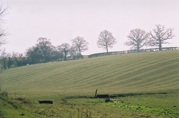 Valley-bottom farmland with scattered farms and winding lanes, relict medieval open field cultivation represented by strip fields and ridge and furrow, the fieldscape evidently reorganised into a pattern of large irregular fields after the Middle Ages.
Historic background
Early settlement and land use is possibly indicated by a 2nd-century Roman coin found near Cloy House. The historic character area formed part of the medieval ecclesiastical parish of Bangor Is-y-coed and probably includes areas of land farmed by the self-sufficient early medieval community at Bangor in the late 5th and early 6th century. Documentary evidence of the 16th and 17th centuries suggests the existence of open fields which probably had their origin in manors established at both Bangor and Overton and farmed from those settlements in the early Middle Ages. An expansion in woodland clearance and the extension of arable farmland probably took place in the southern part of the area as a consequence of the Crown's policy of free timber and land being offered rent-free for 10 years to English settlers taking up residence in the new borough of Overton in the 1290s, and probably involving some lands confiscated from native Welsh landowners who had sided with Llywelyn in the previous decade. An early mill site is probably indicated by the place-name Millbrook, to the south of Bangor Is-y-coed, first recorded in 1290 as Milnbrook.
Key historic landscape characteristics
The historic landscape character area occupies an undulating swathe of farmland between Bangor Is-y-coed and Overton, to the west of Mill Brook, a tributary of the Dee, generally lying between 30-60 metres above Ordnance Datum. Present-day land-use is predominantly pastoral, though there are some small parcels of broadleaved and deciduous woodland plantation.The fieldscape is predominantly one of large irregular fields though there are clear patterns of strip fields representing former open fields particularly on the southern and eastern sides of both Bangor and Overton. Documentary evidence of the 16th century suggests at least two open fields at Bangor called 'Maes mawr' and 'Maes y groes' divided into strip fields often with Welsh names. The widespread survival of ridge and furrow within the historic landscape area is probably also to be associated with medieval open field cultivation. Many of the areas of ridge and furrow are found outside the areas where strip fields have survived, however, suggesting that widespread reorganisation of the landscape took place following enclosure of the open fields during the late medieval and early post-medieval periods. Marl pits, probably mostly of late medieval and early post-medieval date, are widely distributed throughout the area.
Settlement is generally confined to quite widely scattered farms and smallholdings, mostly with English names, some of which appear to have emerged from the break-up of the medieval open fields during the later medieval and early post-medieval periods. Characteristic buildings reflecting the history of land use and land tenure in the area include Plas yn Coed, originally a large, late 17th-century brick-built set on a stone plinth, the mid 18th-century brick-built farmhouse at Argoed, a model example of an estate farmhouse reflecting the prosperity of the area at that time, finally Brynhovah Cottage, an 18th-century smallholder's house and attached byre, together with frequent small and medium-sized brick-built farmhouses and outbuildings of 19th-century date. The settlements are typically linked by such as Musley Lane, Cloy Lane, Cae-Dyah Lane and Millbrook Lane, which wind their way though the fields and which are probably mostly of medieval or earlier origin.
Sources
Sylvester 1969Silvester et al. 1992
Wiliam 1986
Listed Buildings lists
Regional Sites and Monuments Record
For further information please contact the Clwyd-Powys Archaeological Trust at this address, or link to the Countryside Council for Wales' web site at www.ccw.gov.uk.
Privacy and cookies