Cymraeg / English

|
Maelor Saesneg Historic Landscape |

|
Character area map |
Historic Landscape Characterisation
Maelor Saesneg:
Bryn-y-Pys
Bangor Is-y-coed and Overton communities, Wrexham County Borough
(HLCA 1117)
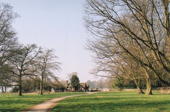 Varied, picturesque area of meadowland, farmland, wooded slopes, former parkland belonging to a number of country houses, and race-course bordering the eastern banks of the River Dee, including a number of strategic river crossings.
Historic background
Early settlement is possibly represented by the possible prehistoric Iron Age hillfort on the banks of the Dee, known as Gwernheylod Banks promontory fort, formerly interpreted as a damaged medieval motte and bailey castle. The strategic importance of the area is probably also indicated by the fact that an important manorial centre had been established in this area by Madog ap Meredudd, ruler of Powys, in about 1138, thought to have been associated with a castle now washed away by the River Dee in the Asney Park area. A mill had been established, probably on the bank of the Dee near the present weir south of Min-yr-afon by the end of the 13th century. A fishery, presumably for salmon, had also been established here by the late 13th century, the fishing rights here at one time being owned by the Cistercian monastery at Valle Crucis.
Key historic landscape characteristics
Meadowland and farmland on the eastern bank of the River Dee, generally between 15-60 metres above Ordnance Datum, with sinuous strips of ancient broadleaved woodland with some more recent conifer and poplar plantations on the steeper slopes and river banks. Modern land use is predominantly pasture.Present-day settlement is largely confined to a number of scattered farms together with a small number of roadside houses and cottages, including several lodges and other buildings formerly associated with country houses. Late medieval and possibly earlier settlement is represented by the half-timbered house at Althrey Hall, about 1.5 kilometres to the south-west of Bangor Is-y-coed, possibly built on the site of an earlier moated hall, and thought to have been built for Richard ap Howel in the late 15th century. The high status of the house has been recognised for many centuries, having been described by John Leland as 'a fair house' in the 1530s and drawn by the topographical artist John Ingleby in 1780. Two further important gentry houses in the character area have been demolished - Gwernheylod House, a house dating from the 17th century, demolished in about 1860, and Bryn-y-Pys, a Georgian house, probably built in the 1730s and demolished in the 1950s - which formed the centres of landed estates, both associated with buildings which reflect an earlier 19th-century interest in building model examples of estate buildings. Gwernheylod lay on the edge of the wooded area associated parkland near the bank of the Dee, and amongst other things is survived by and earlier 19th-century brick-built stable-block with a central light well with dove boxes, and by the earthworks of a former 18th-century folly in Castle Wood from which small cannon were once fired on occasion. The country house at Bryn-y-Pys which once lay about 1.5 kilometres to the north-east of Overton, is similarly survived by its former parkland, by its former brick-built 18th-century stable range with coachhouse and dovecote with about 80 doveboxes, together with characteristic entrance lodges, gate piers and gates. The house, then the seat of Richard Parry Price, was visited by Thomas Pennant in the 1780s when it possessed a fine collection of birds including a pair of Angolan vultures.
The picturesque setting near the banks of the River Dee played an important role in the development of this group of country houses in the 18th and earlier 19th centuries. In the case of Gwernheylod (Gwernhailed) Pennant commented as follows:
'the seat of Mr. Fletcher, in this parish, must not pass unnoticed. Few places command so rich a view; and few have been more judicously improved. It stands on the lofty brow that skirts the country. Beneath runs the Dee'.
The Dee at Overton Bridge is described by Pennant as flowing 'picturesquely between lofty banks, admirably described by the inimitable pencil of Mr. Sandy', reproduced in his Twelve Views of North Wales published in 1776. Surviving early 19th-century buildings in which exploited the picturesques setting of Overton Bridge include the large stone-built house at Min-yr-afon, possibly remodelled from an earlier building. Characteristic of the larger yet more modest farmhouses in the character area is Asney Park, a late 18th-century two-storey brick-built farmhouse, brick with slate roof, in a loop of the Dee about 2 kilometres to the north-west of Overton.
Some discrete areas of ridge and furrow have been recorded near Althrey Hall, Asney Park Farm and Maes-Gwaelod which probably represent small medieval open field, also suggested by the place-name element maes. The medieval origin of the ridge and furrow is also suggested by documentary references to strip fields in the area of Althrey in the 13th and 14th century. References are also made to the dole field or common meadow at Althrey in the mid 16th century, which presumably occupied the riverside meadows in the area now occupied by Bangor Racecourse. The riverside meadows to the west of Overton and elsewhere along the river bank were likewise probably occupied by common meadows intermixed with strips of woodland and relatively small and scattered ploughlands. The present-day field pattern is dominated by a pattern of relatively large irregular fields which emerged from this diverse pattern of land use as a result of enclosure probably from the mid 16th century onwards. Significant farm-buildings include the 17th-century timber-framed barn at Althrey Woodhouse. Marl pits, probably mostly of late medieval and early post-medieval date, are thinly scattered across the area, in the fields above the floodplain.
The area is crossed by the main road from Overton to Ruabon and Wrexham, a former turnpike road which crosses the River Dee at Overton Bridge, an early 19th-century stone bridge which replaced an earlier ferry. A further ford and ferry crossed the river at the southern end of the area, between Erbistock and Llan-y-cefn.
Sources
Lewis 1833Howson 1883
Hubbard 1986
King 1983
Pennant 1784
Pratt 1965
Pratt & Veysey 1977
Smith 1988
Smith 2001
Silvester et al. 1992
Sylvester 1969
Williams 1990
Listed Building lists
Regional Sites and Monuments Record
For further information please contact the Clwyd-Powys Archaeological Trust at this address, or link to the Countryside Council for Wales' web site at www.ccw.gov.uk.
Privacy and cookies