Cymraeg / English

|
Maelor Saesneg Historic Landscape |

|
Character area map |
Historic Landscape Characterisation
Maelor Saesneg:
Mulsford
Willington Worthenbury community, Wrexham County Borough
(HLCA 1122)
 Predominantly agricultural landscape of scattered farms of late medieval origin associated with ridge and furrow cultivation and irregular field patterns with 'green' settlement at Tallarn Green.
Historic background
Early settlement within the historic landscape character area of perhaps the 8th to 10th century is suggested by the place-name Broughton which contains the Anglo-Saxon place-name element -tun indicating a farm or small settlement, though the name itself is only first recorded in the 1530s. By the early 19th-century Broughton Hall had become the focus of a small agricultural estate which occupied much of the parish of Worthenbury which probably emerged from the enclosure of former common open fields. The 'green' settlement at Tallarn Green, which appears to represent encroachment within a former area of common grazing, was first documented by Edward Lhwyd in the 1690s.Key historic landscape characteristics
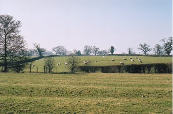
Relatively low-lying rural agricultural area, between about 15-50 metres above Ordnance Datum, gently sloping to the north and west, and down to the Wych Brook on the eastern side of the area which forms the boundary between Wrexham and Cheshire. The character area contains a reasonably high proportion of ridge and furrow which probably has its origins in medieval open field cultivation. Fieldscapes are dominated by large and small irregular field boundaries, the association between ridge and furrow and irregular field patterns perhaps indicating widespread reorganisation of field boundaries in the post-medieval period. Numerous marl pits are scattered throughout the area, many of which are now ponds. Modern land use is mostly pasture, with field boundaries formed by multi-species hedgerowsThe earliest visible settlement evidence in the area is represented by the moated site to the south of Tallarn Green which probably represents a small medieval manorial centre of the later 13th or 14th century. A latter settlement pattern is represented by the distribution of farms in the area, some of which probably emerged from the break up and enclosure of the former commons in the later medieval period. Characteristic of this period are the farmhouse at Glandeg and Oak Farm, both of which contain traces of former timber-framed buildings of perhaps the early 17th century, both subsequently extended in brick in the 19th century, smaller rural dwellings of this period being represented by Bridge Cottages, Tallarn Green. Broughton Hall, which probably originated in at least the earlier 16th century, and described in Lewis's Topographical Dictionary of Wales as 'a spacious mansion', shared the same fate as many other former country houses in Maelor Saesneg, being demolished in 1961, survived by two of three former gate lodges.
The long linear settlement at Tallarn Green occupies a spur of land between the Wych Brook and one of its tributaries, merging on the north-west with the settlement that has grown up around Sarn Bridge. At the time of the enclosure award of 1770s it consisted of a narrow tract of unenclosed land occupied by about a dozen dwellings. The enclosure award divided the common into fields and formalised a road along the length of the spur, thus opening the way for the construction of new cottages besides the road on what had previously been common land. The complement of buildings in Tallarn Green are characteristic of a relatively modern settlement of this form, including a new stone church the early 1870 dedicated to St Mary Magdalene, a parsonage of the 1880s with some half-timbering, together with the Kenyon Cottages of the early 1890s, two single-storeyed dwellings for widows with a labourer's house between, in a timber-framed, revivalist vernacular style considered appropriate for philanthropic buildings of this kind, and the Tallarn Green Temperance Room, a purpose-built Methodist Temperance Room, dated 1890, probably also built by Lord Kenyon of Gredington, an active promoter of the Temperance Movement.
Sources
Charles 1938Harrison 1974
Hubbard 1986
Lewis 1833
Pratt 1964
Silvester et al. 1992
Smith 1988
Spurgeon 1991
Sylvester 1969
Listed Building lists
Regional Sites and Monuments Record
For further information please contact the Clwyd-Powys Archaeological Trust at this address, or link to the Countryside Council for Wales' web site at www.ccw.gov.uk.
Privacy and cookies