Cymraeg / English

|
The Middle Wye Historic Landscape |

|
Character area map |
Historic Landscape Characterisation
The Middle Wye:
Trebarried
Bronllys, Felinfach and Talgarth, Powys
(HLCA 1085)
Nucleated medieval church settlement of Llanfilo and scattered medieval and later farmsteads on undulating lower hill land on west of the Llynfi, a number of the farms originating in smaller medieval manors and subtenancies held by either English or Welsh families.
Historic background
Earlier prehistoric activity in the area is attested by the Pipton Neolithic long cairn, to the north of Trevithel, by several probable Early Bronze Age burial mounds, and by the find of a late Bronze Age socketed bronze axe. Later prehistoric settlement is indicated by the Pen-rhiw-wen and Hillis hillforts on the western side of the area, which reflect tribal organisation in the area during the pre-Roman Iron Age. By the early medieval period the area fell within the cantrefs of Cantref Mawr, Cantref Selyf and Glasbury within the kingdom of Brycheiniog. Evidence of settlement at this period is lacking, though the early church site at Llanfilo, set within a circular churchyard, hints at the presence of a pre-conquest nucleated bond settlement. Following the Norman conquest led by Bernard de Neufmarchť. in the 1080s the area formed part of the marcher lordship of Brecknock. By the 14th century a number of smaller manors had been created, those at Pont-y-wal and Bryndu being held by English families and those at Trephilip, Trebarried and Tredomen being held by Welsh families. At the Act of Union in 1536 the area fell within the hundred of Talgarth in the county of Brecknock. The area formed part of the tithe parishes of Bronllys, Glasbury, Llandefalle, Llanfilo, Llyswen and Talgarth in the middle of the 19th century.
Key historic landscape characteristics
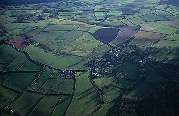
Predominantly east-facing undulating lower hill land to the west of the Llynfi and south of the Wye, lying between a height of between 120-280m above Ordnance Datum, broken by a number of shallow stream valleys generally lined by alders. The soils are mostly well-drained fine reddish loams (Milford Series) overlying sandstone. Modern land-use is largely pasture, with areas of ancient semi-natural broad-leaved woodland at Dderw Wood, overlooking the Wye, and along a number of stream valleys, with small scattered broad-leaved and conifer plantations elsewhere. A small area of upland Common Land survives at Llangoed Common, near Brechfa Pool.
Present-day settlement is characterized by a number of contrasting patterns. One is represented by the probably pre-conquest nucleated medieval church settlement of Llanfilo, surrounded by its former open fields. A second is represented by dispersed medium-sized upland and lowland farms, about 1-1.5km apart, many of which have their origins in medieval manors established following the Norman conquest, many with names, such as Trebarried, Trephilip, Tregunter, and Trevithel, derived from well-established families in the area. A further settlement pattern is represented at the small nucleated township settlement at Tredomen which is focused on a cluster of four small farmhouses together with a number of 18th-century farmworkers' cottages and modern bungalows. Some of the smaller farmsteads on higher and more marginal ground have been lost and amalgamated with other farms since the beginning of the 20th century, farm buildings sometimes being retained even though the farmhouses are now only visible as ruins or earthworks. Earthwork evidence of house platforms and hollow-ways to the east of the village of Llanfilo suggest that the village was much larger in the medieval period.
The earliest surviving building horizon is represented at Pentre Sollars, a small cruck-built farmhouse of about the 16th century, subsequently extended in stone. A similar sequence is suggested at the sandstone rubble house at Tredomen Court which contains some 16th century fabric. Most other early buildings are of late 17th to early 18th-century date, again of stone rubble construction. Slate is now the most commonly used roofing material, though scattered stone tiles are to be seen here and there as in the case of St Bilbo's Church, Llanfilo, and this was probably the most common roofing material up to about the end of the 18th or the beginning of the 19th century. Characteristic of the lower-lying farms in the area is the late 17th- to early 18th-century sandstone rubble farmhouse with brick dressings at Trephilip. The 18th- and 19th-century farm buildings at Trephilip are again characteristic of the development of farm complexes in the area from the 18th-century onwards, and include a barn, cowhouse, and hay barn with cart doors and vertical slit vents. The earlier buildings are of stone rubble with slate roofs and the later 19th-century buildings are of stone rubble with red and blue brick dressings. Similar farm complexes are to be seen at Penmaes and Penishapentre within the village of Llanfilo, and at Tregunter, Felin-newydd Home Farm, Pont-y-wal Home Farm and Tredomen Court, the farm buildings often set around a farmyard. The 19th-century stone rubble farmhouse at Tregunter, part pebble-dashed, for example, is associated with a 18th to 19th-century stone cowhouse and two-storey granary, the late 18th-century brick gentry house associated with the farm here having been demolished in the 1920s. Other large gentry houses of 17th-century date are associated with several low-lying farms as at Trebarried and Trevithel. Characteristic 19th-century farmworkers' cottages at Trevithel, are of sandstone rubble with yellow brick dressings.
Former medieval open fields appear to be represented by surviving areas of ridge and furrow near Mintfield, Penishapentre, Glandwr, Tredomen, Trephilip, and south-west of Tredustan, and probably also by the field-names such as Maes Pwll and Maes Coglan near Tredustan, given in the Tithe Apportionment, which incorporate the element maes. The present-day agricultural landscape of the area is characterized by medium-sized irregularly-shaped fields which appear partly derive from the enclosure of former open fields associated with the former medieval manors and partly from the gradual process of woodland clearance and enclosure in the surrounding countryside during the medieval and later medieval periods, leaving residual areas of upland common such as that around Brechfa Pool. Field boundaries are generally represented by multi-species hedges including hazel, holly, and hawthorn and ash, with scattered mature oaks on some boundaries, though there are some straighter, single-species hawthorn hedges in some higher areas which probably represent later 18th to earlier 19th-century enclosure of former upland commons. Many of the hedges are becoming degraded and are being replaced by post and wire fences, though a proportion of field boundaries have disappeared since about the end of the 19th century and are now represented by no more than low banks. Some of the boundaries on steeper land are associated with and low stone clearance banks, occasionally containing substantial boulders or with orthostatic revetments. Likewise, a number of the fields on steeper slopes are associated with substantial lynchets, sometimes up to 1-2m high, indicating that cultivation has been more extensive in the past. Occasional roughly-hewn stone gateposts survive which are probably pre-date the 19th-century. Extensive orchards accompanied a number of the farms in the area in the 19th century and possibly earlier, including Trebarried, Trephilip, Penishapentre, Trevithel, Tredomen, of which occasional traces survive.
Many of the minor roads lanes which skirt around field boundaries and run in distinct hollow-ways 1-2m deep on the steeper slopes are likely to be of medieval origin. The straighter roads which cross the area are generally late 18th- and early 19th-century turnpike road improvements. A number of earlier bridges, including several built during the turnpike period, have now been replaced by modern bridges, including Felin-newydd Bridge and Pontybat, reconstructed in the 1930s and the more recent bridge at Pont Trephilip.
Only limited evidence of former industry survives in the area. A stone cider press at Penmaes Farm, Llanfilo, is one of the few physical reminders of a once flourishing local cider industry. Several water mills once existed in the area, including one on the Llynfi near Glandwr, one on the Triffrwd (a tributary of the Dulas), one at Gwern-y-bedd near Felin-newydd, and Trebarried Mill with its leat from the Dulas. Former limestone quarries and limekilns to the north of Tredomen, and near Draen, Hillis, and Court Llwyfen are recorded on Ordnance Survey maps published in the late 19th century. A number of other small scattered quarries were probably used for building stone from about the 17th century onwards.
The historic landscape area includes a number of important defensive sites, including the probably Iron Age hillforts at Pen -rhiw-wen above Llyswen and at Hillis, and a smaller enclosure is known near Court Llwyfen. Several medieval moated sites are known in the area, at Cwrt-coed, Llanfilo, and near Hillis.
Early prehistoric funerary and ritual sites include the Pipton long cairn and several possible round barrows on the hilltop to the east of Tredomen. More recent religious sites within the historic landscape character area include the medieval St Bilbo's Church, Llanfilo and the 19th-century Bethesda United Reformed Chapel. St Bilbo's Church, built of local stone rubble, characteristically lies at the heart of the medieval nucleated settlement and is probably of pre-conquest origin. Bethesda Chapel, like many other nonconformist chapels in the area is sited on the margins of the Common Land, in this instance on the hilltop next to Brechfa Pool on Llangoed Common, and like other contemporary buildings in the area it is of stone rubble construction with brick dressings.
A picturesque landscape park was created along the brook to the west of the former gentry house at Tregunter in the later 18th century, partly by damming the stream which forms a tributary of the Dulas. Similar landscape parks, represented by plantings of 18th to 19th-century date survive around Trephilip and at Felin-newydd, on the western boundary of the historic landscape character area. Possible remains of a formal garden are suggested by earthworks at Trebarried House.
Sediments preserved at the Brechfa Pool upland mire are of potential importance to an understanding of the environmental history of the area.
Sources
Bevan & Sothern 1991;
Bowen 2000;
Briggs 1991a;
Cadw 1995a;
Cadw 1995b;
Coplestone-Crowe 1992-93;
Grove 1962;
Haslam 1979;
Hughes 1990;
Jenkinson 1997;
Jervoise 1976;
Jones 1993;
Jones & Smith 1964;
Powys Sites and Monuments Record;
Rees 1932;
RCAHMW 1986;
Silvester 1999a;
Soil Survey 1983;
Spurgeon 1981;
Williams 1976
For further information please contact the Clwyd-Powys Archaeological Trust at this address, or link to the Countryside Council for Wales' web site at www.ccw.gov.uk.
Privacy and cookies