Cymraeg / English

|
The Middle Wye Historic Landscape |

|
Character area map |
Historic Landscape Characterisation
The Middle Wye:
Gro
Clyro, Glasbury, Gwernyfed and Llanigon, Powys
(HLCA 1086)
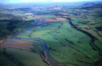
Floodplain of the Wye between Glasbury and Hay, with oxbow lakes and river meanders and large rectangular fields representing late enclosure of former low-lying common meadow.
Historic background
Little is known of the history of the medieval motte in the middle of the floodplain south of Llowes, though it probably belongs to the Norman conquest period. It appears to be associated with rectangular earthwork enclosure, possibly of Roman military origin. It lies next to an ancient meander of the Wye and may once have guarded a former fording point across the river. In the mid 19th century the area formed part of the tithe parishes of Clyro, Glasbury, Hay, Llanigon, and Llowes.
Key historic landscape characteristics
Low-lying floodplain of the Wye, liable to flooding, at about 80m above Ordnance Datum, with low river banks and pebble beaches along the river. There are numerous oxbow lakes and palaeochannels, some holding water only seasonally, together with streams and oxbow lakes lined with alder and willow. The soils are predominantly alluvial, being generally either deep stoneless permeable silty soils and stoneless fine or coarse reddish silty soils (Teme and Lugwardine Series). Present-day land-use is mainly pasture, though a number of orchards formerly existed on the slightly higher margins of the area, near Glan-hen-Wye, Lower Sheephouse, and Little Ffordd-fawr.
No settlement falls within the area at the present day and the only building structure is The Barn, built at the junction of a radiating pattern of field boundaries on the floodplain to the south of Clyro. The area is principally divided into large rectangular fields generally with limited-species low-cut hedges, generally of hawthorn, often being strengthened or replaced by post and wire fences which probably represents relatively late enclosure of former common meadow land belonging to the parishes of Clyro, Glasbury, Hay, Llanigon, and Llowes. The area is crossed by a number of ditches and dykes, some of which possibly originate from drainage schemes of the late 17th and 18th centuries onwards.
Sources
Powys Sites and Monuments Record
Soil Survey 1983
For further information please contact the Clwyd-Powys Archaeological Trust at this address, or link to the Countryside Council for Wales' web site at www.ccw.gov.uk.
Privacy and cookies