Cymraeg / English

|
The Middle Wye Historic Landscape |

|
Character area map |
Historic Landscape Characterisation
The Middle Wye:
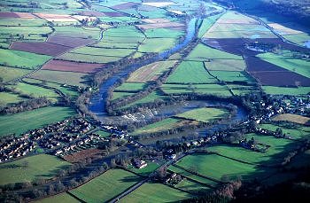
Llyswen
Bronllys and Glasbury, Powys
(HLCA 1087)
Nucleated medieval church settlement and manors and extensive former open field cultivation on well-drained lower-lying ground spanning the Wye, with later building and structures resulting development of road and railway transport systems in the 18th and 19th centuries.
Historic background
There is no certain evidence of prehistoric settlement in the area, though possible Bronze Age burial mounds are recorded. Llyswen, meaning 'white court', appears to have become an important religious and administrative centre in the early medieval period. Strategically sited on the south bank of the river Wye, at an important river crossing, it is supposed to have been the site of a clas or mother church, given to the See of Llandaff in the 6th century. The site of this early religious centre is possibly occupied by the present-day church of St Gwendoline, a local 9th-century saint said to be buried at Talgarth. The churchyard is sub-circular in shape, suggesting an early foundation. Llyswen is also the supposed site of the court of the 9th-century prince, Rhodri Mawr. In the medieval period an early castle is thought to have been built at Llyswen, though its site is unknown. Following the Norman conquest the area around Llyswen, to the south of the Wye, was administered as a lowland manor within the marcher lordship occupying Cantref Selyf and administered from Bronllys. By the later medieval period the area formed part of the medieval ecclesiastical parishes of Llyswen, Boughrood and Glasbury.
Key historic landscape characteristics
The area occupies the valley-bottom and lower hill slopes to the north and south of the river Wye, between a height of 90-170m above Ordnance Datum. The soils are well-drained fine loams (Rheidol Series) overlying glaciofluvial gravel in the lower-lying parts of area, and well-drained fine reddish loams overlying sandstone (Milford Series) in northern and southern parts of the area. The present-day land-use is largely pasture.
The modern settlement pattern is focused on the nucleated settlements of early medieval and medieval origin at Llyswen and Boughrood (the latter lying just outside the historic landscape area), with older farms within the settlements and later farms and cottages generally encroaching upon the margins of the former medieval open fields which surrounded the villages. The linear settlement development to the west of Llyswen is related to the improvement of the turnpike road and the construction of the toll bridge across the Wye at Boughrood in the early 19th century, buildings here including Victorian and Edwardian riverside villas and rectory, sited on part of the former open fields. Some substantial farms within villages of Llyswen and Boughrood probably have their origin in the amalgamation of earlier holdings during the course of the later medieval and early post-medieval period.
Little evidence has survived above ground of the early buildings which once existed within the historic landscape character area and which in the early medieval and medieval periods are likely to have been largely timber-built. The church at Llyswen perhaps lies on the site of both the pre-conquest and post-conquest medieval churches, but this was rebuilt in the 1860s, leaving nothing earlier above ground apart from the medieval font. The earliest buildings within the character area are largely stone-built structures dating from the 18th and 19th centuries. Buildings within the village of Llyswen include 18th and early 19th-century sandstone rubble stone cottages, some rendered and the later ones often with brick dressings. There are a number of later 19th-century brick cottages and houses, including a several larger houses, such at Ty Mawr, accompanied by extensive gardens. Lower House farmhouse in Llyswen is of sandstone rubble construction but has ashlar dressings which give it a genteel appearance. Also within the village are several stone barns, possibly of 18th-century date, with ventilation slots. The wall of the former animal pound on the south side of the village survives as a garden boundary.
The impact of the improvements to the turnpike road and the erection of the Boughrood Toll Bridge is reflected in the presence of later 18th- and early 19th-century Griffin Inn, Bridge End Inn and the former Star House, building materials characteristically comprising sandstone rubble with brick window and door dressings. There is an amount of modern infill housing within the village, including a small housing estate and isolated bungalows. Rural buildings are consistently of stone and include the 18th-century complex at Pistyll Farm, with stone farmhouse, stone-walled yard, and outbuildings with stone gable walls and weatherboarded sides. The late 18th to early 19th-century farmhouse at Glangwye is characteristically of rendered sandstone rubble construction, and forms part of a complex which includes an 18th- to 19th-century stone barn, earlier 19th-century stables and coachhouse of stone rubble with sandstone dressings, and 20th-century steel-framed outbuildings. Both farms lie on the edge of the former open fields within Boughrood parish, just above the floodplain of the river Wye and possibly represent late encroachment onto the former watermeadows along the north bank of the Wye. A cluster of 18th-century and more recent stone cottages at Boughrood Brest represent encroachment onto the former open fields of Boughrood. A scatter of modern roadside cottages and houses occupy the headlands of strip fields elsewhere.
Llyswen probably had three common fields, one to the west of the village, one in the loop of the river to the north of the church, and one to the south-west of the village, named in the mid 19th-century Tithe Apportionment as Maeslan Cafan, Common Field, and Maes Megan. A similar pattern is evident in the adjacent parish of Boughrood, to the north of the Wye. Substantial areas of the open field in the loop of the river to the west of the village remained unenclosed until they were enclosed in the 1850s, other former areas of open field having probably been enclosed during from at least the beginning of the 18th century onwards. The pattern of medieval open fields can still be traced in the distinctive pattern of strip fields and some ridge and furrow running up and down the contour on the sloping ground above the river between Boughrood Brest and Boughrood village, characteristically with overgrown multi-species hedges. Some elements of the field pattern have been lost as a result of recent hedge removal, though a number are still indicated by slight lynchets and low banks. Traces of the Llyswen open fields are likewise visible to the south of the river on the small area of flat land above the floodplain surrounding the village and on the sloping ground to the south-west in the area of Maes Megan, represented by a distinctive pattern of strip fields and in some instances by ridge and furrow. The fields here are bounded by low-cut or overgrown or occasionally laid multi-species hedges, with some green lanes between the original strip fields and some lynchet formation on sloping ground. Many of the houses and cottages throughout the character area are associated with small ageing orchards. These are the remnant of extensive areas of orchard that were to be seen in and around the village of Llyswen in the 19th century, especially in the vicinity of Lower House, Maes Megan and Maeslan Cafan on the south side of the river in the area of Lower Middle Road, Boughrood Brest, Pistyll and Glangwye on the north side of the river. Some of the orchards were evidently planted on areas of former medieval open field cultivation, which in some instances probably date to at least the 17th or 18th century.
Llyswen experienced a new lease of life in the early 19th century with the improvement to the turnpike road leading northwards to Builth, cutting through the former open fields to the west of the village. Further expansion came in the wake of the new and important Boughrood Toll Bridge, opened in the 1830s and by the Mid Wales Railway opened in the 1860s, with a station on the north bank of the river at Boughrood, which remained open until the 1960s. The embankment of the railway leading to the former bridge across the Wye, cutting across the former open fields to the east of Llyswen, forms a distinctive landscape feature within the area.
Little evidence of former industry survives within the character area. There are no known mills at Llyswen itself, though the former 18th-century stone-built water corn mill at Boughrood, operated by means of a weir and leat from the Wye, ceased working in the early 20th century and was dismantled in 1940.
St Gwendoline's Church, Llyswen possibly lies on the site of a church said to have been given to the See of Llandaff in the 6th century, a possible alternative site of this early church being in Llangoed Park. The building was extensively renewed in the 1860s but appears to take the plan of its medieval predecessor. The former earlier 19th-century nonconformist chapel at Llyswen was built by the Calvinistic Methodist and was administered by Trefecca College for many years.
Sources
Cadw 1995b;
Cadw 1995d;
Haslam 1979;
Jervoise 1976;
Lowe 1985;
Martin & Walters 1993;
Powys Sites and Monuments Record;
Silvester 1999b;
Sylvester 1969;
Soil Survey 1983
For further information please contact the Clwyd-Powys Archaeological Trust at this address, or link to the Countryside Council for Wales' web site at www.ccw.gov.uk.
Privacy and cookies