Cymraeg / English

|
The Middle Wye Historic Landscape |

|
Character area map |
Historic Landscape Characterisation
The Middle Wye:
Tir-mynach
Clyro, Powys
(HLCA 1096)
Orderly lowland farming landscape laid out on hummocky glacial moraine, with a field pattern possibly reflecting the presence of a Roman fort and medieval monastic grange.
Historic background
Early settlement in the character area is indicated by the find of a Neolithic polished stone axe and scatters of Mesolithic, Neolithic and Bronze Age flintwork. A Roman fort was built near Boatside Farm probably as a temporary encampment during the Roman conquest of South Wales, possibly as early as AD 50-60, the fort probably sited in relation to a fording point across the Wye at this point where the valley narrows. The character area fell along the southern edge of the medieval kingdom of Elfael, whose boundary at this point lay along the river Wye. Following the Norman conquest an area of land at Tir-mynach ('Monk's Land') was granted as a grange to the Cistercian abbey at Cwmhir, the grange probably also to be associated with medieval buildings surviving at Court Farm, Clyro. At the Act of Union in 1536 the area fell within the hundred of Painscastle in Radnorshire. In the mid 19th century the area fell within the ecclesiastical parish of Clyro.
Key historic landscape characteristics
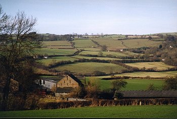
Low-lying hummocky landscape, between 80-120m above Ordnance Datum, on a glacial moraine between Clyro and Hay, deposited by the Wye valley glacier. Predominantly deep well-drained reddish coarse loamy soils with some fine loamy soils with slowly permeable subsoils and slight seasonal waterlogging (Esrick 2 Series), especially along the Clyro Brook. A number of permanent pools and waterlogged areas here, such as Peter's Pool, form a distinctive element of the landscape, accompanied by pollarded willows and a number of ancient alders. The river Wye cuts through the glaciofluvial deposits near Hay, creating steep river cliffs as at Wyecliff. Present-day land use includes pasture with some arable and some fodder crops.
Modern settlement is confined to the dispersed farms at Boatside Farm, Tir-mynach and Lower House Farm, together with a number of roadside workers' cottages. The present buildings are mostly of sandstone rubble, rendered in the case of Tir-mynach, and area principally of late 18th- to early 19th-century date. Farm buildings including a stone barn with ventilation slits at Tir-mynach. A stone-walled kitchen garden and tree plantings give a gentrified aspect to the landscape west of Boatside Farm
The farming landscape is characterized by medium-sized fields with irregular boundaries suggesting various phases of enclosure from the medieval period onwards, the arrangement of fields possibly reflecting the presence of the Roman fort at Boatside Farm and possibly an early large enclosure surrounding the medieval monastic grange at Tir-mynach. The Monk's Well is a former spring which supplied the Tir-mynach farm. There are traces of ridge and furrow on the edge of the area between Clyro Court and Clyro Mill which may have belonged to medieval open fields belonging to the village of Clyro. The field boundaries in the area are generally formed by low-cut multi-species hedges including holly, hazel, maple and ash. A number of fields have been amalgamated in recent years, former fields in some instances being indicated by lynchets, old field banks and isolated mature trees which once fell along field boundaries. The fields are laid out in relation to the roads and lanes which cross the area. The winding lane between Boatside Farm and Lower House Farm runs in a distinct hollow-way for part of its course and is evidently of some antiquity.
Former industry is represented by the Clyro Mill a former ?18th-century water corn mill on the Clyro Brook, which ceased working in the 1920s, and whose leat and millpond are now filled in. Clay pockets within the glacial moraine were also worked from time to time, represented by a clay pit near Wyecliff, south of Clyro, and a disused pit to the west of Tir-mynach, which appear from surface finds of pottery to have supported a local post-medieval pottery kiln. Kilvert's diaries mention brick kilns in operation in the area in the 1870s, which no doubt supplied building materials for the regeneration of Hay, though production had evidently ceased by the late 1880s, presumably due to competition with kilns elsewhere. Defensive sites are represented by the Clyro Roman fort, a temporary fort of the early conquest period, just to the north of Boatside Farm, and possibly by an adjacent Roman marching camp, known from aerial photography. The moated site at Lower House probably represents the site of a defended medieval farmhouse.
Sources
Cadw 1994a;
Jarrett 1969;
Powys Sites and Monuments Record;
RCAHMW 1986;
Soil Survey 1983;
Thomas 1959;
Williams 1990
For further information please contact the Clwyd-Powys Archaeological Trust at this address, or link to the Countryside Council for Wales' web site at www.ccw.gov.uk.
Privacy and cookies