Cymraeg / English

|
The Middle Wye Historic Landscape |

|
Character area map |
Historic Landscape Characterisation
The Middle Wye:
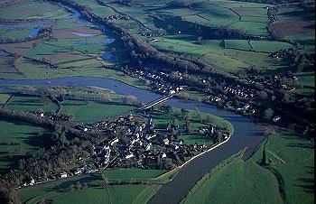
Glasbury
Glasbury and Gwernyfed, Powys
(HLCA 1097)
Post-medieval linear settlements along communications corridor, superimposed upon medieval nucleated settlement at important early river crossing on the Wye.
Historic background
Administratively, the area has had a somewhat chequered history owing to the dislocation of earlier settlement patterns caused by civil and ecclesiastical boundary changes and the development of new lines of communication. During the medieval period the area fell within an extensive ecclesiastical area focused on the clas or mother church dedicated to St Cynidr at Glasbury. The earliest historical reference to Glasbury is in 1056, but it is probable that the church and settlement originated in the early medieval period. Following the conquest of Brycheiniog by Bernard de Neufmarché in the 1080s the area formed the sub-lordship of Glasbury. In line with the ecclesiastical reforms introduced following the conquest the church was refounded in about 1090 and dedicated to St Peter's. This church, which it is assumed lay on the same site as the pre-conquest clas church, was sited between the confluence of the Wye and Llynfi, on the east bank of the Wye. It seems likely that the church was associated with a nucleated settlement originating in the pre-conquest period which seems likely to have been in the area of the present village of Glasbury on the west bank of the river. The former earthen castle at Glasbury lay on this bank of the river, on the western edge of the present village, and probably formed the administrative centre of the medieval manor of Glasbury whose existence is known from about the late 13th century. The castle was in existence by the 1180s, but was lost to housing development in the 1970s. The open fields of the manor, named maes y llan issa, maes y llan ucha, and maes y pentre in documents of the 1640s, also lay on the west bank of the river, and extended northwards into the area emparked around Maesllwch Castle in about the 18th century, only a few of the original strips being left by the mid 19th century.
Glasbury lies on one of the natural crossing points of the Wye, where the valley is at its narrowest, and this is likely to have influenced the siting of the pre-conquest clas church and the Norman castle at Glasbury. A ferry across the Wye at Glasbury is first mentioned in 1311, and the earliest mention of a bridge at this point appears to be a reference in 1665 to a former bridge at Glasbury, further upstream from the present bridge, near the confluence of the Llynfi. The crossing was to remain insecure until the later 19th century, successive bridges of timber and stone giving way to floods in 1738, 1777, 1795 and 1850. From the Act of Union in 1536 the civil and ecclesiastical parishes of Glasbury to either side of the Wye formed part of Radnorshire. In 1844 the portion to the south of the river was transferred to Brecknock by Act of Parliament, the division being made along the middle of the river. A dispute arose over the repair of the bridge following the damage caused in 1850 and although it was made safe for foot passengers it fell again and was replaced by a ferry boat for a time. Plans were drawn up for the repair, to be of wood with stone piers. A legal dispute arose over the cost of the repairs, however, following the transfer of the southern part of Glasbury parish to Brecknockshire from Radnorshire, as a consequence of which the new bridge had stone piers on the southern side of the river and wooden trestles on the northern side for a number of years until the bridge was completed in stone. The present bridge is 20th-century. The separate civil parish of Glasbury, Brecknock, survived only until 1883 when it was amalgamated with the new civil parish of Tregoyd and Felindre, which itself became part of the new community of Gwernyfed created in the early 1980s. In the local government reorganisation of 1974 Brecknockshire and Radnorshire were combined within the new county of Powys. The old parish church by the river was abandoned in the 1660s, following a flood in which the course of the river is said to have changed. A new church dedicated to St Peter was erected on the river terrace to the south of the earlier church, on the Brecknockshire side of the river. The site of the former church is still visible and used to be marked by several yew trees. The new church was rebuilt in the 1830s and remains the parish church of St Peter's, Glasbury. A new church was built at Cwmbach to the north of village of Glasbury in Radnorshire in the 1880s, when the new ecclesiastical parish of All Saints, Glasbury was created.
The present village of Glasbury, to the north of the river, is probably of medieval origin. It is sited in relation to the position of the 17th-century bridge across the Wye, its growth during the course of the later 18th and 19th centuries reflecting its position near the river crossing and along the turnpike road leading into England on the east. The linear extension to the village on the west, towards Cwmbach, is again 18th to early 19th century in origin, and results from the realignment of the public road during the creation of the landscape park from Maesllwch Castle in the middle of the 19th century.
The bridge across the Wye at Glasbury links to a linear settlement stretching for about 4km from Ffordd-fawr on the north-east to Pontithel on the south-west. The linear settlement arose due to the bridges across the Wye at Glasbury and across the Llynfi at Pipton, the improvement of the turnpike road between Brecon and Hay in the late 18th and early 19th centuries, the construction of the Hay-Brecon Tramroad in the period between 1816-18 and its replacement by the Hereford, Hay and Brecon Railway in 1862, and its subsequent linking to the Mid Wales Railway at the Three Cocks Junction. New place-names were needed for the linear settlement on the Brecknockshire side of the Wye, the nucleation near the bridge at the northern end becoming called Treble Hill and the southern end becoming called Three Cocks, after the arms of the Williams family of Old Gwernyfed.
Key historic landscape characteristics
The area lies on the valley bottom and occupies old river terraces just above the floodplain of the Wye, at a height of between 90-100m above Ordnance Datum and encompasses the narrow east-west road corridor from Cwmbach to Glasbury and the bridge across the Wye, and the narrow north-south road corridor between Llwynau-bach to the north of Treble Hill and Pontithel to the south of Three Cocks. The soils are predominantly well-drained fine loamy reddish soils overlying sandstone (Milford Series).
Buildings and other structures within the character area clearly reflect its history and development. An early horizon is represented by two half timbered buildings in the nucleated medieval settlement at Glasbury, the Old Vicarage at Glasbury with a 15th-century roof and stone outer walls, and the Tithe Barn in Glasbury, a 15th/16th-century cruck-built building, again with stone walls. Most of the remaining buildings in the area belong to the period following the improvement of the turnpike roads, including a number of gentry houses of the later 18th and earlier 19th centuries, notably Woodlands, Parc Gwynne and Green House in Glasbury. Some of these houses, such as Glasbury House, were substantial gentlemens' residences, a number of which have now been converted to outdoor education centres. The Three Cocks inn originates in the pre-turnpike period, but was substantially refurbished at this period. Improvements in communications gave rise to new hotels, such as the Maesllwch Arms Hotel in Glasbury. Also belonging to the turnpike era is Glasbury Gate Toll Cottage, the scene of the only recorded incident in the area during the Rebecca Riots in the 1840s. Stables and coachhouses were built in association with a number of the gentlemens' residences and hotels, including the former brick-built stable and coachhouse at Parc Gwynne and at Woodlands, and the stables to the rear of the Maesllwch Arms Hotel. Various buildings and other structures are to be associated with the former tramway and dismantled railway. A two-storey, stone-built, former stable building, alongside the former embankment of the Brecon-Hay tramroad at Llwynau-bach, seems to have been used for stabling the horses employed on the tramway. The buildings later become part of the home farm for Broomfield, a substantial early 19th-century house which was probably built by William Bridgewater, the operator of the Hay-Brecon Tramway which itself lay next to the former goods yard and tramway office known at Glasbury Wharf. Other legacies of the railway era include a series of stone bridge abutments and a fine arched bridge of the 1860s survive at Treble Hill. A number of processing industries sprang up within this communications corridor , including a sawmill on the north bank of the Wye at Glasbury, a mill on the Llynfi at Aberllynfi, and smithy at Glasbury, and a smith and forge at Three Cocks. A large early 19th-century barn was built for a horse-driven threshing machine at Llwynau-bach. A former chemical works at Pontithel produced Naphthalene in the later 19th and earlier 20th century, based on raw materials transported by rail.
Workers' housing appeared in Glasbury and along the roadside between Treble Hill and Pontithel during the course of the 18th and 19th-centuries, represented by earlier stone cottages and later brick cottages with stone dressings and stone cottages with brick dressings. Other buildings relating to the new settlement patterns which emerged in the area included the early 19th-century Methodist rendered stone chapel at Cwmbach, the new stone church dedicated to St Peter of 1837-38, south of the river, the stone-built United Reformed chapel in Glasbury of the 1860s, Treble Hill Baptist Church of 1866, in red brick with stone dressings, and the stone-built All Saints Church north of Glasbury of 1881-82, and the ?earlier 20th-century corrugated-iron community hall adjacent to St Peter's Church. Following the reorganisation of the ecclesiastical parish of Glasbury in the late 19th century a new vicarage was built to the south of the church. Both Treble Hill and Three Cocks continued to expand during the 20th century due to their position on the main road, with areas of infill housing, and retail and light industrial developments.
Sources
Cadw 1995c;
Cadw 1995d;
Clinker 1960;
Baughan 1980;
Brock 2000;
Howse 1949;
Hughes 1990;
Jervoise 1976;
Martin & Walters 1993;
Morgan 1998;
Powys Sites and Monuments Record;
Silvester 1994;
Soil Survey 1983;
Sylvester 1969
For further information please contact the Clwyd-Powys Archaeological Trust at this address, or link to the Countryside Council for Wales' web site at www.ccw.gov.uk.
Privacy and cookies