Cymraeg / English

|
Bro Trefldwyn Historic Landscape |

|
Character area map |
Historic Landscape Characterisation
Bro Trefaldwyn:
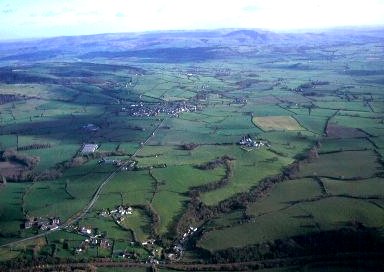
Penylan
Forden, Powys
(HLCA 1065)
Undulating landscape of medium-sized irregular fields with scattered medium to large farmsteads, some probably origins in the 9th and 10th centuries.
Historic background
The character area falls towards the north-west corner of the historic landscape area and formed parts of the townships of Forden, Thornbury, Munlyn, Woodluston and Edderton in the parish of Forden, Montgomeryshire. A number of these townships have their origin as Mercian settlements, probably established after the construction of Offa's Dyke, in the 9th and 10th centuries and abandoned in the 1040s, before the Norman Conquest. Thornbury, Munlyn, Woodluston (renamed Penylan) and Edderton are each listed in the Domesday Book compiled in 1086, under the names Torneberie, Wadelestun and Edritune. Woodluston, which had once comprised up to about 360 acres (3 hides) was waste at the time of the conquest and still deserted when the Domesday Book was compiled. Edderton, with about 120 acres (1 hide) and woodland for fattening 60 pigs, and Thornbury with about 120 acres (1 hide) had been waste at the conquest, but had been recovered by 1086. The motte at Lower Munlyn was probably built at about the time of the Domesday survey, and was probably built, like Hen Domen further to the south, was probably built to protect an important fording point across the Severn.Earlier settlement, in the Iron Age or Roman periods, is possibly represented by enclosure sites revealed by aerial photography to the south of Edderton Hall, to the north of Penylan, and possibly to the west of Gaer Mill.
The watermill known as the Gaer Mill on the Camlad was in operation from at least the later 16th century. It was leased by the Forden workhouse during the last decade of the 18th century and continued in use as a flour mill until the beginning of the 20th century.
Much of the land within the character area had probably been enclosed during the course of the later medieval period, Present-day field boundaries follow the general outline of those which had become established by the middle of the 19th century, though there have been a significant number of amalgamations in certain areas since that time as a result of hedge removal.
Key historic landscape characteristics
Gently undulating land between about 80-150m above OD, predominantly south and west facing, with steeper, west-facing slopes overlooking the Severn, cut by deep, steep-sided stream valleys. The underlying solid geology is of Silurian shales, soils being fine silty and clayey stagnogleys, subject to some seasonal waterlogging. Rounded pebbles from glacial drift frequent in some areas. The predominant modern land-use is pasture with some arable, with small areas of ancient semi-natural deciduous oak woodland and hazel scrub on steeper river and stream slopes, willows and alders along stream banks, and a number of small conifer plantations.Present-day settlement is largely confined to medium to large-sized farmhouses and associated farm buildings, often set on hill crests or slight rises and within their own fields, away from public roads. Amongst the earliest surviving buildings is the 17th-century timber-framed farmhouse at Upper Munlyn, rendered in the 1950s. The façade of a late 17th/early 18th-century timber-framed farmhouse survive at Penylan, with timber-framed outbuilding at The Gaer. Farmhouses are otherwise largely of brick and of 18th/19th-century date, as at Lower Munlyn and the enlarged building at Penylan, roughcast in the case of the gentrified farmhouse at The Gaer. There is an 18th/19th-century stone barn at Lower Munlyn, but generally elsewhere outbuildings are of 19th/20th-century date and of brick, as at The Grove, Penylan, some on stone footings, with some weatherboarded outbuildings at Penylan, and with widespread 20th-century steel-framed farm buildings. Associated with The Gaer is a late 18th-century brick-walled garden, and combined gazebo and dovecote. The farm buildings at Lower Munlyn are thought to occupy the area of the original castle bailey. The large stuccoed house at Edderton Hall, built between 1830-40, possibly incorporating an earlier building, formed the centre of a small estate.
Medium and small-sized fields with boundaries on the more steeply-sloping ground characteristically lying along the contour. Irregular boundaries suggest gradual woodland clearance and piecemeal enclosure from the medieval period onwards. Robust and generally low-cut multiple-species hedges including hawthorn, hazel with scattered mature oaks and some modern hedge-laying. Occasional low field banks and field ditches along natural watercourses.
The area is crisscrossed by numerous minor roads, tracks, and public footpaths, some linking Forden with the former ford and ferry across the Severn at Dyffryn. A number of the minor roads and tracks run in hollow-ways which appear to be of some antiquity. The area is crossed by the line of the Cambrian Railway of 1860, running between the former railway station at Forden and the bridge across the Severn at Cilcewydd, cutting across the earlier field boundaries that it was superimposed upon.
Extractive and processing industries are represented by several disused stone quarries shown on Ordnance Survey maps of the 1880s in the area between Penylan and Edderton Hall, and probably used for building stone. Parts of the former 18th/19th-century brick mill buildings of the Gaer Mill have been incorporated in a more recent house, and although most of the original leat has been filled in the point at which the mill race was taken off the Camlad is still visible to the south of the road to Thornbury.
The former parkland and orchards at Edderton Hall, shown on Ordnance Survey maps of the 1880s has now largely disappeared except for two artificial, embanked fishponds and a parkland drive.
Published sources
Barker & Higham 1982Barton 1999
Baughan 1991
Eyton 1854-60
Spurgeon 1965-66
Soil Survey 1983
Sothern & Drewett 1991
Thorn & Thorn 1986
Vize 1882
For further information please contact the Clwyd-Powys Archaeological Trust at this address, or link to the Countryside Council for Wales' web site at www.ccw.gov.uk.
Privacy and cookies