Cymraeg / English

|
Bro Trefldwyn Historic Landscape |

|
Character area map |
Historic Landscape Characterisation
Bro Trefaldwyn:
Yr Ystog
Churchstoke, Powys
(HLCA 1069)
Early medieval and medieval nucleated church settlement and expanding modern village, on boundary between valley and hill edge, medieval and early post-medieval encroachment by small farms and cottages onto hill land to north.
Historic background
The character area falls within the Welsh portion of the 19th-century township and parish of Churchstoke. The church was formerly attached to the to the parish of Chirbury, the church at Churchstoke being one of the two pre-Conquest churches mentioned in the Domesday Book of 1086. At the time of the Norman Conquest the land at Cirestoc was in Mercian hands, but with one Welsh farmer, the total amount of land being worked at that time amounting to up 600 acres (5 hides) together with woodland for fattening 100 pigs. The place-name Churchstoke is derived from the two Old English elements 'church' and 'stoke' (stoc) meaning 'church place'. The Welsh name Yr Ystog is first recorded in the mid 16th century and is derived from the English name. The name Old Church Stoke is first recorded in the mid 16th century.The Domesday settlement fell within the hundred of Witentreu but later in 1086 became part of the lordship of Montgomery, newly created by Henry I. Subsequently, it went to form part of the hundred of Halcetor. A mill at Churchstoke was granted to the Augustinian canons of Snead in about 1190, a mill still evidently being in operation in the late 13th century. The canons had transferred to the priory at Chirbury by 1194, and in 1291 the church at Churchstoke was still held by Chirbury priory. The motte and bailey castle at Simon's Castle, just to the east of Churchstoke was probably founded some time during the 12th to early 13th centuries, there being some uncertainty whether the castle at Sned recorded in the 1230s was Simon's Castle or alternatively Castle Hill, Hyssington.
Key historic landscape characteristics
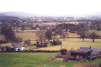
Sloping land between the Camlad and Todleth Hill, looking south and west, between a height of 125-250m above Ordnance Datum. The underlying solid geology is composed of relatively narrow north-south bands of Ordovician mudstones, shales and grits and flaggy calcareous sandstone, with number of thin beds of volcanic tuffs. Soils are predominantly fine silty and clayey stagnogleys, subject to some seasonal waterlogging.The village of Churchstoke lies at the interface of several topographic zones, on the edge of the valley land of the Camlad-Caebitra confluence to the south and also on the edge the higher hill land to the north. The scattered village of Churchstoke lies to either side of a bridge across the Camlad. The earliest surviving structure is the 13th-century stone tower of St Nicholas's Church, set in circular churchyard, the remainder of the church having been largely rebuilt in the 19th century. Other prominent buildings include the rectory of 1846, the former late- 18th and 19th-century stone school and schoolhouse, and late 19th-century polychrome brick Methodist chapel of 1879. The earliest surviving houses include the late 16th-century timber-framed Churchstoke Hall, extended in the mid 17th century, Fir Court dated to 1685, and Royal (Rail) House, with fragments of 17th-century timber-framing elsewhere, as at Green Farm with 18th-century brick front, and at the Court House Inn, with late18th-century to early 19th-century remodelling. Other larger and smaller 18th to mid 19th-century stone and brick houses, including Todleth Hall, Broadway House and Ivy House. 18th century stone cottages and mid 19th-century terraced brick cottages and probably early 18th-century stone Horse and Jockey Inn. Modern school and rapidly expanding modern housing on northern and eastern side of village. Several small farms on outskirts of village, with weather-boarded outbuilding and 19th/20th-century brick and steel-framed outbuildings at Green Farm and late 19th/early 20th-century brick farmhouse and outbuildings on site of former brickworks just to west of village. There are two single-arch stone bridges in the village across the Camlad, North Bridge, a late 19th-century bridge with modern reinforcements, and the 18th-century South Bridge. The eastern side of the village is dominated by a large modern retail complex.
Relatively dense scatter of small farms and cottages on the higher ground north of village of Churchstoke, with a small nucleated settlement at Old Church Stoke including 17th-century timber-framed farmhouse with 18th-century stone enlargement at Glebe Farm, 17th/18th-century stone-built former Oak Inn, and stone Primitive Methodist Chapel of 1860. Other scattered farms, often within about 400m of each other, include the half-timbered farmhouse at Bryncyn, a small complex with 18th-century stone hay barn and small brick farmhouse at Blue Barn, a rendered stone farmhouse at Todleth Farm, and some derelict stone cottages.
The present-day field pattern of small irregularly-shaped fields had already emerged by the mid 19th century, probably largely as a result of gradual, piecemeal woodland clearance and enclosure during the later medieval and early post-medieval onwards, most of the fields being generally small and irregularly-shaped fields often with low-cut or laid multiple-species hedges, with lynchets on steeper slopes, and some holly hedges on higher ground. There has been some loss of field boundaries since the 19th century, a number of earlier fields being indicated by mature oaks in the middle of some present-day field boundaries. Most of the land had evidently been enclosed by the early 19th century, with the exception of narrow stretches of unenclosed common along the banks of the Camlad to the north of the church, in the area still known as The Green, and a number of fields between Old Churchstoke and Roundton, which have since been enclosed from the common, the latter fields having planted, single-species hawthorn hedges, with a small number of boundaries on higher ground, near rock outcrops having drystone walls. Traces of ridge and furrow possibly representing medieval open-field arable cultivation have been recorded in the village, in the field opposite Churchstoke Hall.
The main road through the village (A489) running along the contour on the edge of the valley of the Camlad was improved as a turnpike road in the late 18th century, but probably lies on a much more ancient route. Winding lanes on the higher ground, up to Old Church Stoke and on the west side of Todleth Hill, partly running in a hollow-ways and partly terraced into the hillside.
Former industry is represented by water-filled clay on the western outskirts of the village to either side of the road to Sarn (A489), marking the site of a brickworks which producing bricks, drainage-pipes, flowerpots 'and vases and other pottery based on classical models'. The works were in operation from the 1870s but which had ceased production by the 1920s. There are a number of stone quarries, as at Simon's Castle and in upper part of character area to the north of the village, including a linear quarry alongside the road to the north of Churchstoke Hall which remained in production again until early in the 20th century, working one of the narrow bands of volcanic tuffs running north to south across the area. In the early 17th century the Churchstoke watermill, on the Camlad to the south of the village and possibly on the same site at the medieval mill, was being put back into commission, having been in a state of disrepair for a number of years, but it appears to have gone out of use again by the 19th century.
Published sources
Anon 1908Arnold & Huggett 1985; 1986; 1987; 1988
Barton 1999
Charles 1938
Davies 1945-46
Ellis 1935
Eyton 1854-60
Chibnall 1973
Haslam 1979
Hogg & King 1967
Lewis 1833
Lewis 1915
Lloyd 1880
Mountford 1928; 1932
Owen 1907
Silvester 1992
Silvester & Frost 1999
Soil Survey 1983
Thorn & Thorn 1986
Toghill 1990
Willans 1908
For further information please contact the Clwyd-Powys Archaeological Trust at this address, or link to the Countryside Council for Wales' web site at www.ccw.gov.uk.
Privacy and cookies