Cymraeg / English

|
Tanat Valley Historic Landscape |

|
Character area map |
Historic Landscape Characterisation
The Tanat Valley:
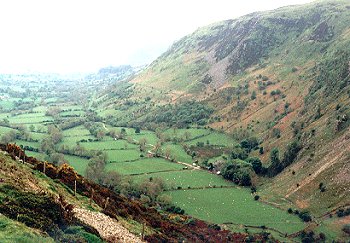
Cwm Rhiwarth, Llangynog, Powys
(HLCA 1013)
Remote and isolated, deeply glaciated valley with clustered small farms with small enclosed fields on lower slopes and valley bottom.
Historic background
The character area falls within the medieval ecclesiastical parishes of Llangynog and formerly lay within the ancient commote of Mochnant Uwch Rhaeadr, Montgomeryshire.
Key historic landscape characteristics
Gently sloping and flatter land on the lower valley sides and along the banks of the Afon Eirth, between about 205-350m OD, enclosed by the steep and dramatic crags and screes on the higher sides of the valley, particularly on its western side. The valley is constricted just to the west of Llangynog, lower ground being less than 0.5km wide here, with slopes of mixed woodland including birch, willow and maple. Further to the north-west the valley broadens out to between 0.8-1km across, before narrowing to between 0.3-0.4km across towards the head of the valley. Steeply wooded erosion scarps intermittently along river edge. Braided river course and intermittent waterlogged areas with rushes in places, the river-bed being raised and embanked by boulder banks in places. Dry, seasonal stream-beds, towards head of valley. Numerous fast-running streams and ravines, cutting across the contour.
Fairly dense scatter of small farms and cottages, appearing to form several distinct clusters at various points along the valley and often set alongside streams. Relatively small 18th/19th-century farmhouses and outbuildings of local stone, some with stone-walled yards at Pencraig (with attached barn), Nant, Glan-yr-afon, Eithin, Llwyn-onn, Ty'n-y-ffynonydd and Tre-rhiwarth, most of which are still working farms, the farmhouses at Buarth-glas and Ty'n-y-pant being rendered. Rebuilt, ?late 19th-century farmhouse at Ty-mawr. Deserted 18th-century farmhouses and outbuildings at Nant-yr-henglawdd, Tyn-y-celyn (with ruinous barn attached). Scattered holiday caravans.
Small, gently sloping and flat fields, now mostly pasture, with boundaries predominantly either along the contour or up and down the slope. Lynchets along field boundaries on steeper ground indicate areas more frequently ploughed in the past. Some fields with low field-clearance banks and often over-grown hedges, with spaced trees and larger shrubs, and now supplemented by stockproof post and wire fencing. Drystone wall boundaries, as in the Pencraig and Tre-rhiwarth areas where abundant stone available from surface clearance and screes. Occasional boundaries of upright slate slabs in the area of Tre-rhiwarth, at the head of the valley.
Some clusters of small strip fields, notably between Buarth-glas and Glan-yr-afon (where field boundaries have been recently levelled) seem to be rare survivals of medieval open arable fields. Other larger enclosures appear to represent late medieval and early post-medieval enclosed pasture, including some larger parcels defined by stone walls and clearance banks, subsequently subdivided by single-species, hawthorn hedges, now often overgrown. Mixed-species roadside hedges, including sycamore, ash, hazel, blackthorn and hawthorn, with some former and some recent, grant-aided, hedge-laying on roadside and other hedges. Rough-hewn stone slab roadside field gateposts. Small remnant areas of semi-natural oak woodland on steeper rocky slopes and outcrops and blackthorn scrub on some wasteland areas, and small conifer plantations on steeper slopes. Stands of alder and willow along the river and stream banks and watercourses.
The more ancient routes in the valley is the narrow winding lane linking the farms along the western side of the valley and the network of footpaths and green-lanes linking farms on the eastern side of the valley, the main road on the eastern side being the turnpike road between Llangynog and Bala, constructed in the late 18th century. These older lanes run in hollow-ways or terraces cut into the side of the hill, the sides of which are revetted in stone in places, some of the un-made up lanes also acting as seasonal streams. Communication between farms on either side of the valley was originally by fords though there are now a number of modern farm bridges and timber footbridges. A low bridge of flat stone slabs survives across one of the watercourses south-east of Tre-rhiwarth. The sides of the valley are generally so steep that communication with the surrounding hill land is restricted to a number of paths along the larger stream valleys along the sides and at the head of the valley. Carefully-designed 18th-century turnpike road from Llangynog to Bala, terraced into slope, revetted with drystone walling.
For further information please contact the Clwyd-Powys Archaeological Trust at this address, or link to the Countryside Council for Wales' web site at www.ccw.gov.uk.
Privacy and cookies