Cymraeg / English

|
Tanat Valley Historic Landscape |

|
Character area map |
Historic Landscape Characterisation
Dyffryn Tanat / The Tanat Valley:
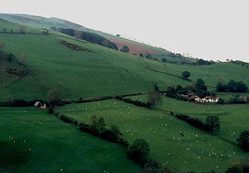
Henfache, Llanrhaeadr-ym-mochnant, Powys
(HLCA 1021)
Large, widely spaced farms on lower ground and more closely spaced, medium-sized farms on lower hill-slopes, late medieval cruck-built halls and field systems.
Historic background
Early settlement, possibly of Iron Age date, is indicated by a cropmark enclosure on sloping ground to the north of Henfache and a second possible site further south. The area falls within the medieval ecclesiastical parish of Llanrhaeadr-ym-mochnant and also includes a narrow portion of the parish of Llanarmon-mynydd-mawr, which was formerly a dependent chapelry within the parish of Llanrhaeadr. Administratively, the area fell within the commote of Mochnant Uwch Rhaeadr, Denbighshire.
Key historic landscape characteristics
Relatively well-drained undulating lowland between the Afon Iwrch and Afon Rhaeadr, including the lower edge of Moel Hen-fache and Mynydd Mawr, on the southern edge of the Berwyns, varying in height from about 170m to 360m OD. The steep-sided, wooded valley of the Afon Iwrch cuts through the eastern side of the area, with waterlogged areas on lower-lying flatter ground on the south-east side of the character area.
Roadside farms and smallholdings. Larger, low-lying farms, including Henfache with a large, stone farmhouse with datestone of 1702, and later 18th-century brick extension, 18th/19th-century quarried stone outbuildings, brick dressings and weatherboarding, stone-walled yard, 'megalithic' stone gateposts and 19th-century squared stone gateposts. Converted 19th-century roadside cottages at Tai-newyddion and Penfforddwen, of rounded clearance boulders. 18th/19th-century rendered stone farmhouse and stone outbuildings at Sychnant, of quarried and field-clearance stone, some weatherboarding on outbuildings. The older buildings survive on the sides of the hills around the margins of the character area. Stone farmhouses with and outbuildings at Bryn Coch and Plas-yn-glyn, the farmhouses incorporating respectively a cruck-framed late medieval hall house and a possibly 17th-century timber-framed house. Slightly to the north is the former cruck-framed hall house (Ty-draw, Llanarmon-mynydd-mawr), converted to a barn and now dilapidated. Slightly further to the north again is a stone-revetted platform probably representing a further cruck-built building. This remarkable line of series of late medieval and early post-medieval structures all lie on a trackway running round the contour on the western slopes of Mynydd Mawr. These are associated with the distinctive field system noted below and indicate the amalgamation of earlier smaller holdings. Cluster of 18th/19th-century medium and small quarried stone farmhouses and outbuildings on lower slopes of Moel Hen-fache, including Ty-draw with rendered farmhouse, Tyn-y-cae and Tan-y-ffordd Ochor with brick dressings. Some evidently represent late medieval farms since one of the stone outbuildings at Tan-y-fford was a cruck-built hall house. surviving as farm building at Tan-y-ffordd Ochor. Traces of earlier stone buildings in the modern farm complex at Ty-cerrig.
Present-day land-use predominantly pasture. Mixed-species roadside hedges, including holly, hawthorn and maple, with evidence of former hedge-laying. Medium-sized irregular fields over much of the lower-lying ground with boulder clearance banks up to 2m wide and 1m high in places with overgrown or patchy hedges. Some larger enclosures defined by clearance banks, subdivided by single-species hawthorn hedges. Linear fields with clearance banks and drainage ditches on wetter ground north-west of Pont Cefnhir. Ridging in some poorly-drained low-lying fields. Low banks and lynchets on more sloping ground, the latter showing that arable land was formerly much more common. Distinctive field system on western slopes of Mynydd Mawr, with some more rectangular fields with boundaries along the contour and at right-angles to the slope, some fields now run into one, and some abandoned fields on the higher slopes above. The field system here is associated with the series of late medieval and early post-medieval cruck and timber-frame buildings north of Bryn Coch, noted above, and represent late 15th- to early 16th-century enclosure. Scattered mature oaks and ashes in hedgerows and around farms. Semi-natural woodland on steeper slopes and taller willows and alders along watercourses.
Winding roads and trackways generally running along the contour with hollow-ways, revetted with rounded field clearance boulders on the lower-lying ground and rock-cut on higher ground. Green lanes and trackways between farms, some now abandoned.
Sources
Hubbard 1986Smith 1988
Smith & Hague 1958
For further information please contact the Clwyd-Powys Archaeological Trust at this address, or link to the Countryside Council for Wales' web site at www.ccw.gov.uk.
Privacy and cookies