Cymraeg / English

|
Middle Usk Valley Historic Landscape |
|
|
Back to description |
Historic Landscape Characterisation
Middle Usk Valley:
Llan-ddew
Photographs of character area
|
|
|
|
|
|
|
|
|
Cymraeg / English
|
|
Historic Landscape CharacterisationMiddle Usk Valley:
Llan-ddew
|
|
|
|
|
|
|
|
|
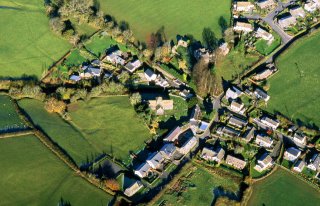 The crossroads at the centre of Llan-ddew village, viewed from the south. The medieval cruciform church lies to the left of the crossroads, and in the field beyond this are earthworks which most probably represent medieval fishponds. The fortified medieval bishop’s palace is visible just to the right of centre. The site of archaeological excavations investigating the site of medieval house plots are visible in the field in the foreground.
Photo: CPAT 05-C-128.
The crossroads at the centre of Llan-ddew village, viewed from the south. The medieval cruciform church lies to the left of the crossroads, and in the field beyond this are earthworks which most probably represent medieval fishponds. The fortified medieval bishop’s palace is visible just to the right of centre. The site of archaeological excavations investigating the site of medieval house plots are visible in the field in the foreground.
Photo: CPAT 05-C-128.
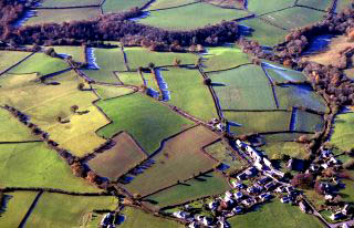 Fieldscapes just to the west of the village of medieval origin at Llan-ddew, visible at the bottom right, viewed from the north-east. The characteristic strip fields combined with dog-legged boundaries and remnant traces of ridge and furrow cultivation represents enclosed medieval open-fields associated with the church settlement which probably first originated in the early medieval period.
Photo: CPAT 05-C-121.
Fieldscapes just to the west of the village of medieval origin at Llan-ddew, visible at the bottom right, viewed from the north-east. The characteristic strip fields combined with dog-legged boundaries and remnant traces of ridge and furrow cultivation represents enclosed medieval open-fields associated with the church settlement which probably first originated in the early medieval period.
Photo: CPAT 05-C-121.