Cymraeg / English

|
Middle Usk Valley Historic Landscape |

|
Character area map |
|
|
More photographs |
Historic Landscape Characterisation
The Middle Usk Valley:
Tal-y-llyn
Llanfrynach, Llan-gors and Talybont-on-Usk communities, Powys
(HLCA 1174)
Undulating lowland fringing the northern side of the Usk valley and including part of the watershed of the river Llynfi. Landscape of predominantly medium to large-sized irregular fields, dispersed farmsteads and small church settlements of early medieval and medieval origin. Early settlement and land-use indicated by prehistoric burial and ritual monuments. Small post-medieval settlements relating to now-abandoned 19th century tramroad and railways.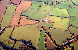
Historic background
Substantial evidence of early and later prehistoric settlement and land use in the area is indicated by lithic chance finds, the Ty Illtud Neolithic chambered long cairn near Llanhamlach, several possible round barrows of probable Bronze Age date and the possibly Bronze Age Llanhamlach standing stone.The line of the Roman road between Abergavenny and Brecon Gaer is assumed to run across the southern and western parts of the area, though its precise course is unknown. A Roman milestone with two early 4th-century inscriptions found built into farm buildings at Millbrook is probably to be associated with the course of this road. Further evidence of Roman activity is provided by a coin hoard found near Cefn Brynich. Early medieval settlement and land use is indicated by the 6th-century commemorative stone known as the Victorinus Stone found to the south-east of Scethrog on the probable line of the Abergavenny to Brecon Gaer Roman road, the 7th/9th-century and 10th/11th century inscribed stones at Llan-gors church, the 10th/11th-century decorated stone in Llanhamlach church, and by the 10th/11th-century sculptured stone at Llanfrynach church.
Historical evidence points to royal and episcopal associations with the area of Llan-gors from early times. A charter of about the 8th century in the Book of Llandaff (Liber Landavensis) records the grant by king Awst (Augustus) of Brycheiniog and his sons Eliud and Rhiwallon to bishop Euddogwy (Oudoceus) and his successors of a royal estate (territorium) the boundaries of which are appear to correspond to the ecclesiastical parish of Llan-gors which lies to the north and east of Llangorse Lake. The grant included its fish and its fishery for eels and therefore included the lake. The charter also records the donation by Awst of his own and his sons’ bodies to the church for burial, suggesting that the church may have been a royal burial ground. Another charter describes a meeting in the clas (‘monastery, mother church’) at Llan-gors in about 925 between king Tewdwr ab Elise (or Elisedd) of Brycheiniog and bishop Libiau.
Before the Norman conquest the area formed part of the eastern edge of the cantref of Cantref Selyf to the north of the river Usk. Shortly after the conquest Cathedine, together with the parish of Llanfihangel Tal-y-llyn and part of Llan-gors were assigned by Bernard de Neufmarché to the defeated Welsh prince Gwrgan ap Bleiddin ap Maenarch but later possessed by Bernard himself, the eastern part of the area forming part of the medieval Marcher lordship of Blaenllynfi and subsequently the hundred of Talgarth. Cwrt y Prior in Llangorse community, said to be occasional residence of the priors of Brecon; Llanthony Abbey also had land in the parish granted in early 14th century. Twmpan Motte, near Treberfydd is probably associated with a manorial estate established after the normal conquest. The area later formed part of Pencelli Hundred, and parts of the 19th-century tithe parishes of Cathedine, Llanfrynach, Llansantffraed, Llangasty Tal-y-llyn, Llanhamlach, Llanfihangel Tal-y-llyn, and Llan-gors.
Key historic landscape characteristics
Gently undulating fieldscapes fringing the northern side of the Usk valley, east of Brecon and to the west of Mynydd Llan-gors and encircling the western side of Llangorse Lake, generally between a height of 120-250 metres above sea level. Fieldscapes are predominantly medium and large-sized irregular fields with hedged boundaries probably representing anciently enclosed land created in piecemeal fashion from prehistoric and Roman periods onwards but there are some distinctive field patterns of strip-field form with dog-legged boundaries near Llanfihangel Tal-y-llyn and Llan-gors which represent the amalgamation and enclosure of medieval open-field furlongs. The land is mostly well-drained but with unimproved lowland grassland and some marshy land on the more poorly-drained ground around the western margins of Llangorse Lake. Modern land use is predominantly grassland but with some arable, which appears to have been more widespread in the past.Settlement is characterized by a distinctive pattern of small nucleated church settlements of early medieval or medieval origin (some of which appear to be shrunken settlements), dispersed farms of medieval, late medieval and early post-medieval origin and a number of smaller country houses of 18th- and 19th-century date which were the focus of small landed estates, as well as several small nucleated settlements which arose from their position along turnpike roads or the railway during the 19th century.
Today, Llansantffraed and Llangasty Tal-y-llyn comprise little more than parish churches of medieval origin, adjacent to substantial houses or farms, and possibly in origin proprietary churches established by prominent landowners, Llansantffraed is first recorded at about the beginning of the 12th century and Llangasty Tal-y-llyn in the early 14th century. The two larger nucleated settlements at Llan-gors and Llanfihangel Tal-y-llyn each include several village farms which express their agricultural origins. Llan-gors is of early medieval origin, the present church, largely rebuilt in the later 19th century is associated with early medieval inscribed stones suggesting an origin in the 7th to 9th century. The modern village includes an inn, school, and chapels and former smithy and corn mill. The village contains a number of substantial stone-built houses of 17th-century and later date including Pendre Uchaf House and Ty Mawr farmhouse, with associated farm buildings of 18th-century date. Llanfihangel church and settlement is likewise probably of early medieval pre-Conquest origin. The church was again largely rebuilt in the later 19th century but was probably originally set within a much earlier curvilinear churchyard now partially encroached upon by later buildings. The modern settlement includes a nonconformist chapel and former smithy. An area of relict building platforms and hollow-ways to the north-east of the village centre suggest that the village may have shrunk in size since the medieval period. Its former agricultural status is indicated by areas of surviving ridge and furrow cultivation probably representing former medieval open-field cultivation to the north and south-west of the village centre.
Non-parochial nucleated settlements developed at Scethrog, Tal-y-llyn and Pennorth. Scethrog lies to the north of an earlier focus at The Tower, with earlier 16th-century Hen Persondy (‘Old Vicarage’) and a number of 18th-century houses and barns at Neuadd and Scethrog Farm. Tal-y-llyn and Pennorth arose from their position at the junction of roads and former railways.
Vernacular farmhouses and outbuildings of 17th to 19th-century form a distinctive element of the built environment of the character area, and includes a number of earlier buildings of longhouse type, set up and down the slope, with a barn or byre at the lower end of the house, as well as a number of farm complexes set around a farmyard. Characteristic examples include Ty Gwyn (Pennorth), Powis Terrace House and Lower Pendre (Llan-gors), and Llan House (Llangasty Tal-y-llyn). Characteristic stone barns, cartsheds and granaries, sometimes with narrow ventilation slits, survive at Ty Newydd (Scethrog), Brynderwen (Tal-y-llyn) and Ysgubor Newydd (east of Pennorth), the latter probably estate-built. Hemley Hall Cottage, probably 16th-century in origin is an unusual survival of an earlier small cottage.
The character area also includes a number of distinctive 18th- and 19th-century small mansions, gentry houses, and fashionable, gentlemans’ farmhouses with associated farm buildings, some of which have origins in the 16th or 17th century. These houses, sometimes prominently sited, appear in a variety of vernacular, classical or Gothic Revival styles and which form a distinctive element of the rural built environment. They are generally stone-built and some are associated with small landed estates. Examples include Scethrog House, Manest Court, Newton House, Trebinshwn, Llansantffraed House, Ty Mawr (Llangasty Tal-y-llyn), and Treberfydd, some of which are of 16th or 17th-century origin. Higher status village houses of this kind include Neuadd and Bryn-llici (Llan-gors), Old School House (Llangasty Tal-y-llyn), Yr Hen Persondy (Scethrog). The medium-sized country house at Glynderi, Tal-y-llyn, built in 1816, is unusual in being brick built and is most probably associated with the nearby Hay Tramroad.
Several of the larger houses in the character area are associated with notable 19th-century gardens and garden features. Treberfydd House being associated with an ornamental garden, walled kitchen garden, ha-ha and a small area of parkland planting and at Trebinshwm with a rectangular garden partly enclosed by the rear wall of the courtyard behind the house which incorporates a garden room.
A number of important elements of transport history survive within the character area. The course of the Roman road between Abergavenny and Brecon Gaer is thought to be approximately followed by the course of the modern A40, though as yet no physical evidence has been found and its state of survival here is uncertain. A number of the more prominent roads were improved as turnpike roads during the later 18th and 19th centuries, most notably the present A40 which defines much of the southern boundary of the area, along which several milestones of this period survive. The former Hay Tramroad, completed in 1818, was built to carry coal, coke and lime from canal-side wharfs at Brecon into Radnorshire and Herefordshire. It cut through earlier field systems along its course and its construction including the digging of the 500 metre Tal-y-llyn tunnel, now sealed. It continued in operation for 40 years, being superseded by the Hereford, Hay and Brecon Railway in 1862 which reused much of the former course of the tramroad, though traces of its former and embankments and culverts survive in places, as in the case of the section just to the south-east of Llanfihangel Tal-y-llyn. The railway, which became the Mid Wales Railway, eventually closed in 1962. Its former course and a number of associated structures, notably the intact railway bridge at Pennorth as distinctive landscape features.
There are a number slight but characteristic remains of rural industries within the character area including scattered stone quarries of medieval or later date for building stone, together with former village smithies at Llanfihangel Tal-y-llyn and Llan-gors, and a former corn watermill at Llan-gors.
Sources
CCW SSSI citation; CPAT Historic Environment Record; Cadw Listed Buildings Lists; Cadw 1999; Barrie 1994; Burnham 1995; Collingwood and Wright 1965; Crawford 1925; Daniel 1950; Darvill 2004; Emery 2000; Glynne 1886; Grinsell 1981; Haslam 1979; James 1979; Jones, T, 1911; Jones, N W, 1993; Jones and Smith 1964; 1965; Knight 1966; Lewis 1964; Macalister 1949; Martin and Walters 1993; Morgan and Powell 1999; Quiney 1989; Nash 1997; Nash-Williams 1950; Pitman 2000; Powell et al. 1969; RCAHMW 1986; Silvester and Dorling 1993; Rathenbury and Cook 1996; Redknap 1993; Redknap and Lane 1994; Redwood 2001; Stephens 1998; Thomas 1994; Walker and Linnard 1990For further information please contact the Clwyd-Powys Archaeological Trust at this address, or link to the Countryside Council for Wales' web site at www.ccw.gov.uk.
Privacy and cookies