Cymraeg / English

|
Middle Usk Valley Historic Landscape |
|
|
Back to description |
Historic Landscape Characterisation
Middle Usk Valley:
Pencelli-Talybont
Photographs of character area
|
|
|
|
|
|
|
|
|
|
|
|
|
|
|
|
|
Cymraeg / English
|
|
Historic Landscape CharacterisationMiddle Usk Valley:
Pencelli-Talybont
|
|
|
|
|
|
|
|
|
|
|
|
|
|
|
|
|
 Fieldscapes near Brynich viewed from the north. The regular field patterns in this part of the Usk valley appear to represent systematic enclosure and landscape reorganisation during the post-medieval period.
Photo: CPAT 05-C-188.
Fieldscapes near Brynich viewed from the north. The regular field patterns in this part of the Usk valley appear to represent systematic enclosure and landscape reorganisation during the post-medieval period.
Photo: CPAT 05-C-188.
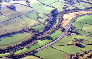
 The modern A40 trunk road towards the foreground near Brynich runs roughly parallel with the river Usk and the Monmouthshire and Brecon Canal. The Brynich Locks lie near the road bridge crossing the Usk towards the right and the canal aqueduct which carries the canal over the river lies just to the left.
Photo: CPAT 05-C-191.
The modern A40 trunk road towards the foreground near Brynich runs roughly parallel with the river Usk and the Monmouthshire and Brecon Canal. The Brynich Locks lie near the road bridge crossing the Usk towards the right and the canal aqueduct which carries the canal over the river lies just to the left.
Photo: CPAT 05-C-191.
 Fieldscapes near Llanhamlach, viewed from the south-east. The isolated Llanhamlach church lies near the banks of the river Usk towards the middle foreground with Peterstone Court Hotel just beyond. The Monmouthshire and Brecon Canal curves around towards the left, where it passes the Ty-newydd marina.
Photo: CPAT 05-C-195.
Fieldscapes near Llanhamlach, viewed from the south-east. The isolated Llanhamlach church lies near the banks of the river Usk towards the middle foreground with Peterstone Court Hotel just beyond. The Monmouthshire and Brecon Canal curves around towards the left, where it passes the Ty-newydd marina.
Photo: CPAT 05-C-195.
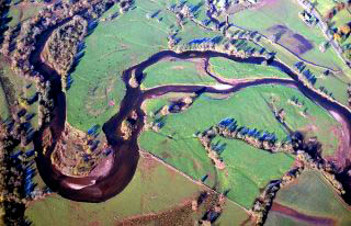 Active river meanders of the river Usk where it occupies the broad alluvial floodplain near Scethrog.
Photo: CPAT 05-C-101.
Active river meanders of the river Usk where it occupies the broad alluvial floodplain near Scethrog.
Photo: CPAT 05-C-101.