![]()
Cymraeg / English

|
Back Home |
|
|
Historic Landscapes |
Historic Landscape Characterisation
Middle Usk Valley: Brecon and Llangorse
Introduction
The following description, taken from the Historic Landscapes Register, identifies the essential historic landscape themes.
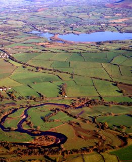
The section of the Usk valley identified here lies to the east and west of Brecon in southern Powys; an area confined on the south by eastern flanks of the Brecon Beacons range and on the north by the southern foothills of Mynydd Epynt. To the east, the western end of the Black Mountains scarp overlooks the shallow basin containing Llangorse Lake which has been included in the area. The Usk valley forms a distinctive and easily accessible corridor across the area, with its wide, flat floor rising gently from 120m above OD at Llansantffraed in the east to 150m above OD at Aberbran in the west. On either side of the valley, the slopes rise to a gently rolling and dissected landscape of low hills, ridges and shallow valleys between 150m and 300m above OD.
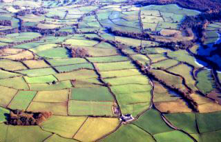
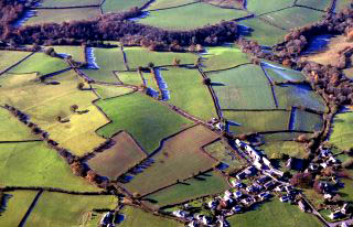
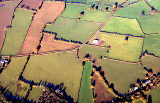
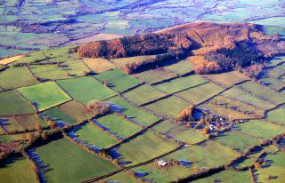
The visual impression of the whole area is dominated by small hedged fields enclosing the rich agridultural land of the valley bottom, and it is in many ways a typical Mid Wales vista. This rich pattern of land use is a product of its complex farming and settlement history, from early Neolithic farmers, through Roman and Norman 'invaders', via the Celtic saints, to the remains of medieval and later agriculture and commerce. Each period of land use has moulded the landscape and each in turn has been overlain and partly obscured by its successors. Almost in contradiction to this continuity, the Middle Usk Valley is also a classic example of a Welsh landscape of domination, conquest and political change, and many of the archaeological and historic elements visible today result from man's imposition of his control on the landscape, not only in the Roman and medieval and later periods, but also in the prehistoric period.
The earlier prehistoric remains are typified by the Neolithic chambered long barrow of Tŷ Illtud, lying in the east of the area between Brecon and Llangorse Lake. This 5000-year-old megalithic tomb comprises a series of drystonebuilt chambers once covered by a long earthen mound. The site is one of a group of such barrows in the Brecon Beacons and the Black Mountains. Although relatively few remains of this remote period survive in this, or in any other, landscape in Wales, these communal burial mounds provide an intriguing glimpse into the life and death of the Neolithic farmers who occupied the Middle Usk Valley. Local tradition says that the empty chambers of Tŷ Illtud were later used as a hermitage by St Illtud in the 6th century, at which time a number of crosses and other Christian symbols were carved into its walls.
The later prehistory of the Bronze Age is represented by a number of round barrows and burial cairns which occupy the higher ground overlooking the rich valley floor of the Usk, which in turn plays host to a number of enigmatic standing stones.
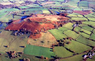
To the west of Brecon lie the impressive remains of Brecon Gaer, the finest surviving example of a Roman fort in Powys. Built within sight of the native Iron Age settlements at Coed Fenni-fach and Pen-y-crug, it guards the Roman road as it descends from Fforest Fawr to cross the Usk and march north into Mid Wales. To the east of Brecon lie the remains of Powys’s only Roman villa, where excavations in the 18th century revealed an outstanding mosaic-floored bath-house. The extent of Roman settlement in the area is unknown, but there is little doubt that the Romans quickly assimilated and exploited the existing pattern of settlement and land use that they would have found surrounding the major Iron Age hillforts at Allt yr Esgair, Slwch Tump, Pen-y-crug and Coed Fenni-fach.
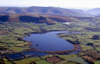
Also to the east of Brecon lies Llangorse Lake, which has an important place in Welsh history and mythology. The small man-made island, or crannog, was constructed as a fortified palace by Brychan, king of Brycheiniog, during the late 9th century and destroyed, according to the Anglo-Saxon Chronicles, in AD 916. A local legend recounts how the lake covers the remains of a city ruled by a cruel and greedy princess who agreed to marry a poor suitor only if he brought her great wealth. The man murdered a rich merchant to gain the princess’s hand, but in revenge, the merchant’s ghost raised a terrible storm which drowned the kingdom. It is not known when the legend originated, but it predates the first archaeological excavation of the crannog in 1850 and is an interesting and perceptive folk memory. More plausibly, as a major royal and ecclesiastical centre in Brycheiniog, the crannog could have a claim to have been the locus scribendi of the early Welsh stanzas, Canu Llywarch Hen, written quite probably between the 8th and mid-10th centuries, when Llangorse and the Brycheiniog dynasty were in their heyday. The remains of this artificial island were fully revealed by excavation during the early 1990s. Llangorse is the only crannog known in Wales, although it is a form common in Ireland; this possible Irish connection is also perhaps evidenced by the large number of Ogam inscriptions in local churches. The lakeside villages of Llangorse and Llangasty-Talyllyn both have probable early Celtic monastic foundations.
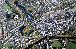
Conquest and settlement from the medieval period are also represented here and history and tradition suggest that the decisive battle between the Welsh forces of Bleddin ap Maenarch and the invading Norman army of Bernard de Neufmarché was fought near Battle in 1092. Norman victory led to the subjugation of the native population and the rise of Brecon town. The earliest castle at Brecon was a motte and bailey, later replaced by a masonry castle. The town also boasts the remains of a Benedictine priory, originally founded in 1100, which, despite its extensive renovation between 1862 and 1874 by the great Victorian architect, Sir Gilbert Scott, still retains many interesting features, such as rare Early English lancet windows and 16th-century conventual buildings. In 1923, the priory, which by then had become Brecon’s parish church, was chosen as the cathedral of the newly formed Diocese of Swansea and Brecon, one of the two new dioceses founded by the new Church in Wales, following its separation from the Church of England. The town also contains a Dominican friary, originally founded in the 13th century, which, although now a school and much altered, is claimed to be the largest single group of Dominican buildings surviving in Britain.
The presence of the castle and these two important ecclesiastical buildings formed the basis of a flourishing medieval town and by the 13th century, the settlement had spread to occupy the lower ground alongside the River Usk, now spanned by a fine stone bridge of 1563, and had been provided with stone defences. Although some of this medieval fabric survives in places, today Brecon’s architecture is characterized by fine brick and stone town houses of the 18th and 19th centuries. Indeed, a population of 5026 placed it as the ninth largest town in Wales at the end of this period. Much of this later architecture survives unaltered and unspoilt by modern development, and combined with its medieval roots this contrives a particularly pleasing and valuable asset, and one that is becoming increasingly rare in other towns in Wales. Today, Brecon is internationally known for its annual Jazz Festival.
Brecon, like its Roman predecessor, was built to maintain the Usk valley as a strategic route into West Wales, and like the Gaer, it is watched over by native settlements of an earlier period, such as Llanspyddid and Llanfrynach, ranged around the rim of the valley. One of these early Welsh settlements, Llanddew, gained fame in the medieval period as the site of the palace of the Bishops of Brecon. This modest castle was occupied between 1175 and 1203 by Gerald of Wales who, as Archdeacon of Brecon, described it as being ‘well adapted to literary pursuits and the contemplation of eternity’ and started his famous tour of Wales from here in the late 12th century. The village displays an impressive set of medieval earthworks indicating its former size and importance.
The Middle Usk Valley is particularly notable for its medieval castles, containing as it does fine examples of the early motte and baileys of the Norman marcher lords, such as those at Aberyscir, Alexanderstone and Treberfydd, stone castles such as at Pencelli, and a fine later medieval defended tower house at Scethrog. Much of the valley retains a medieval character associated with these strongholds, typified by small shrunken villages surrounded by hedged pasture. A particularly impressive example of the former wealth and importance of this area during the medieval period is that of Llanfihangel Talyllyn. Here the former extents of the medieval village are clearly visible, with earthworks indicating former streets and building platforms which once made up almost one quarter of the village. The area is also notable for its large country houses of the 18th and 19th centuries, such as Peterstone Court, and their associated estates, which have built on the landscape of their medieval and early post-medieval predecessors such as Ty Mawr at Llangasty-Talyllyn.
The advent of the Brecon and Monmouthshire Canal (begun in 1799, first opened in 1801 and then joined to the Monmouth Canal in 1812), which winds its way along the southern fringes of the area, connected the valley to the vibrant industrial economies of South Wales. The resulting wharfs and store houses at the canal terminus in Brecon became an important area for agricultural trading and the cloth industry. In the 1860s the canal was, in its turn, eclipsed by the Brecon and Merthyr Railway which connected Brecon to the Great Western Railway at Neath, via Ystradgynlais, in the south, and later to Hereford, via Hay-on-Wye, in the east. Ironically this arterial connection has long since disappeared while the canal, crossed by its characteristic lifting and humpbacked bridges, now provides an idyllic and popular tourist route through the margins of the valley.
|
|
The Making of the Middle Usk Valley Landscape
The forces which have helped to form this landscape of special historic interest in Wales are outlined in the following sections.
|
|
Sources of information
Information on the Middle Usk Valley can be found in various published sources.
 Published sources of information
|
|
Character areas
The following historic landscape character areas have been defined within the historic landscape area.
|
Character areas defined in the Middle Usk Valley Historic Landscape |

|
|
|
|
|
|
|
|
|
|
|
|
|
|
|
|
|
|
|
|
|
|
|
|
|
|
|
|
|
|
|
|
For further information please contact the Clwyd-Powys Archaeological Trust at this address, or link to the Countryside Council for Wales web site at www.ccw.gov.uk.
Privacy and cookies