
|
Back Home |
|
|
Powys Metal Mines |
|
|
Mines index |

|
Mine map |
Powys Metal Mines Survey
Melinygloch
Melinygloch lies in the community of Aberhafesp in the county of Powys. It is located at Ordnance Survey national grid reference SO06649434. The mine is recorded in the CPAT Historic Environment Record as number 18970 and this number should be quoted in all correspondence.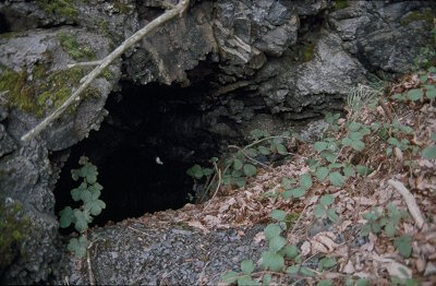 Lead trials (1868)
Geology
Upper Llandoverian Silurian black shales with no evidence of mineralisation.
Workings
Adit aligned SSW/NNE connecting with shaft 40m to NNE. Sub-rectangular adit mouth partially blocked measuring 1.73 x 0.80m. Waterlogged to 3ft depth. Blocked level aligned NNE/SSW at SO06509415. Another blocked level is located to the south at
SO06509433.
Transport
No evidence.
Power
No evidence.
Processing
No evidence.
Other features
No evidence.
Comments
Probably an abortive attempt to locate the eastern extreme of the Van lode. Work done by Melinygloch Lead Mining Co. No ore was seen in the spoil tip.
This HTML page is reproduced from the Powys and Clwyd Metal Mine Surveys which were undertaken between May 1992 and December 1993 by Mark Walters and Pat Frost of the Clwyd Powys Archaeological Trust with financial support from Powys County Council, Clwyd County Council and Cadw: Welsh Historic Monuments. Further information about this site is available in CPAT's Regional Historic Environment Record.
Page produced by Rachel Stebbings and Chris Martin.