Cymraeg / English

|
Flint |

|
Introduction |
|
|
Landscape setting |
|
|
Flint in the prehistoric, Roman and early medieval periods |
|
|
The medieval castle, town and countryside |
|
|
Flint between 1500 and 1700 |
|
|
Industrial expansion of Flint between 1700 and 1950 |
Your Community - Flint
Archaeology and early history of the town
Industrial expansion of Flint between 1700 and 1950
|
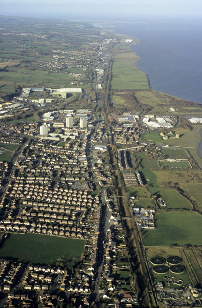
Flint from the east, looking along the railway and turnpike road. The medieval town occupies the upper centre of the picture, with 20th century industrial development beyond it. The 1930s and 1960s housing in the foreground was built over the open fields of the medieval town. Photo: CPAT 08-c-193.
|
The industrialization of the town from about 1700 saw a marked turnaround in its fortunes, rapidly transforming what had become little more than a small rural village into a modern industrial town by the middle of the 20th century.
Agricultural landscapes
From perhaps the beginning of the 18th century agriculture played a gradually diminishing role in the economy of the town but the rural landscape continued to constrain the topography of the town. Until the beginning of the 19th century farmland still extended more or less up to the line of the medieval town defences and the salt marshes along the estuary were still extensively used for grazing.Maps of the period between the mid 18th and the mid 19th centuries show that the process of enclosing the town’s medieval open fields was more or less complete, permitting the introduction of improved farming methods, though the holdings of individual farms and estates were still often widely-scattered. Small cottages had sprung up on the lanes and roads through the former open fields. Small cottage encroachments with attached fields had also begun to appear in the strip of former common land along the Swinchiard Brook to the south of the town, in the area between the Halkyn Road and the Northop Road. Because the tenure of much of the former open fields was still fragmented, the more substantial farms, like Coed-onn Farm, Bryn Coch, Maes-gwyn tended to spring up around the periphery of the open fields. Some of these farms, such as Y Waen, are of 17th-century origin. The Tithe Survey shows that a reasonably high proportion of the land was still being cultivated though stock rearing was also important. Measures to prevent the straying of animals included the setting up of a pinfold (animal pound) close to the south entrance to the town in the area close to the present day Ty Flint.
One of the common remedies for improving soil fertility in the period between about the 16th and 18th centuries was the spreading of subsoil from so-called ‘marl pits’ which often later formed small ponds. Examples of marl pits are known in the former fields to the east of the town, now in the area of the Pentre Recreation Ground and the grounds of St Mary’s Primary School. Agricultural writers of the late 18th and early 19th centuries noted that the gravelly marl in the neighbourhood of Flint most often applied to barley lands, sometimes to pasture and hay, to improve fertility.
Industrial landscapes
The initial impetus to the development and expansion of the town from about the beginning of the 18th century came from the exploitation of local deposits of lead and coal, deposits which had already been worked for many centuries though on a relatively limited scale and probably often on a seasonal basis. Advances in both mining and processing technology presented opportunities for wealth creation that were avidly grasped by industrialists, landowners and investors leading to the emergence of Flint as one of a string of small industrial settlements like Greenfield and Bagillt along the Dee estuary, where there was a significant influx of working people from elsewhere in Britain.Uncertain profits from lead at periods during the 18th and 19th centuries prompted diversification into a wide variety of sometimes interrelated industries, often in rapid succession on the same areas of land. The process culminated in large-scale chemical and textile industries based upon imported materials which became the mainstay of the town’s economy up to the post-war period. Many of the earlier industries were short-lived and sometimes only fleetingly referenced in a footnote, on a plan or by a place-name. Each succeeding generation has tended to clear away what was there before in order to start afresh, leaving few visible signs of the rich industrial history now buried below various parts of the town.
From medieval times water-power had been harnessed for the milling of corn both at Flint Mill on the Swinchiard Brook just to the south of the town and at Croes-ati mill on the stream at Pentre Ffwrndan to the east. Early coalmining had probably also developed from medieval times onwards in a strip of common land to the south of the town. Here, geological fault lines had brought coal seams closer to the surface, and deeper stream valleys made these more accessible to early mining technology via relatively shallow bell pits. Like the town itself, space for developing processing industries was constrained by the farmland still being actively worked around the town. These industries therefore became focused on the shores of the estuary on the northern fringes of the town where building land was made possible by erecting embankments and reclaiming land from the estuary. Here too, a regular water supply was available from the Swinchiard Brook, and both solid and liquid industrial waste could more readily be disposed of into the estuary. The question of pollution began to raise its head in the earlier 19th century and for a short period some of the less pleasant industrial process were relocated to the shores of the estuary at Pentre Ffwrndan, downwind of the town, before eventually being closed down altogether.
Coal mining at Flint remained productive throughout the 18th century, but declined during the 19th century due to competition with much larger collieries elsewhere. In the early 19th century some of the separate smaller workings were grouped together and worked by a single company. Collieries which formerly existed within the boundaries of the town that have now largely built over include mines in the Mount Pleasant area between the Northop Road and the Halkyn Road and the junction of Halkyn Road and Coed Onn Road (Green Pit, Pwll-y-Mwg Pit, Mill Pit and Allt Goch Pit), Marsh Pit close to the banks of the Dee (later covered by the Courtaulds Castle Works) in the area of the industrial estate north-west of the town centre, and also Bath Colliery just to the east of the town centre. Others lay just outside the town, such as the Bryn Coch pit south of Flint High School just outside the boundary to the south and Flint Marsh Colliery along the Old London Road close to the New Cemetery and just to the west of the Aber Park Industrial Estate, just outside the boundary to the north-west. Some of the pits had steam-powered engine houses for winding cages and drainage pumps. Earlier workings had been dependent upon either human or horse power. The introduction of steam-powered engine houses for winding and drainage allowed pits to be sunk to depths of 300–500 feet or more. Working conditions remained harsh, however, and as late as the 1840s it was still being said that ‘children of 8 or 9 years of age are set to work in the coal pits’. The Marsh Colliery and the Green Pit and Pwll-y-Mwg Pit were connected by tramway systems which skirted the western side of the town to the smeltery/transhipment point. Local production dwindled during the second half of the 19th century due to competition with the larger collieries at the Point of Air and in the Wrexham area. By the 1870s only Flint Marsh Colliery remained within the immediate vicinity of Flint, and it too ceased operations in the first decade of the 20th century.
The discovery in the late 17th century of techniques for the use of coal for smelting lead provided a considerable fillip to both the local lead and coal mining industries, giving rise to the construction of the lead smeltery next to the Swinchiard Brook on the shores of the estuary in 1699. This is one of the earliest of the processing industries which became established in this area though there is the suggestion that it may not have been the first. The lead smeltery was apparently known as Gwaith-Halen (‘salt works’) in the 1780s, which suggests the presence of earlier industry on the same site. By-products of the lead smelting industry, notably silver, zinc, calamine, and lead oxides were to form the basis of the chemical industries which became more important later on as the lead industry slumped.
The smeltery took in lead ore brought down by horse and cart from Halkyn Mountain about 5 kilometres to the south and also brought in by sea from other parts of Wales without access to coal resources, as well as from Ireland and Scotland. By the second decade of the 19th century an active market for lead ore had developed in the area, with fortnightly auctions alternately in Flint and Holywell. Coal supplied by local mines formed the fuel, which by the 1840s and 1850s was being transported by a system of horse-drawn tramroads built to the west of the town. Wharves and piers were built for the export of lead bars, sheets and pipes as well as for the export of coal along the estuary to Chester and also by sea to Liverpool and Ireland.
In the early 1820s a substantial tower 140 feet high and 42 feet in diameter was built in order to collect sulphur from the different flues in the lead works. Small-scale boatyards making wooden sailing vessels were established close to the smeltery which remained in operation between about the 1820s to 1860s. By the 1830s other subsidiary industries included a works producing boilers for steam-engines no doubt for use on the coal mines in the neighbourhood and on the lead mines further afield.
An early view of the smeltery is included, perhaps for its novelty value, on the edge of a drawing of Flint Castle by Samuel and Nathaniel Buck in the 1740s, printed in the part work England Displayed published in 1769. The view shows eleven chimneys belching no doubt toxic fumes, and what appears to be an early work’s clock tower. In 1810 Thomas Pennant described the town as ‘blackened with the smoke of smelting-houses’. Other views of the smeltery appear on a Flint Lead Works one penny token of 1813 and on Henry Gastineau’s print of the west side of Flint in Wales Illustrated, published in 1830, the significance of the location being stressed in both instances by ships’ masts and rigging in the background.
The lead industry had gone into decline by the 1840s when the smeltery was superseded by a factory producing alkali and chloride of lime. It was said to be ‘one of the most extensive works of the kind in the world’, and it expanded over the site of earlier wharves and a shipbuilding yard, on the site which became known as the Castle Works within the area of the present-day Castle Park Industrial Estate. Like the lead works, at their height, these works employed many hundreds of workers. Many of those engaged in the alkali works were newcomers, including a sizeable contingent of Irish families seeking employment. These chemicals, produced from sea water and sulphur, were used in the manufacture of bleaching powder, disinfectant and soap. Alkali works were notorious for the pollution they created, particularly from emissions of hydrochloric acid fumes which tended to have a devastating effect upon the neighbouring countryside. The 1849 edition of Samuel Lewis’s Topographical Dictionary of Wales notes the ‘large alkali-works, which have . . . been suspended, and are not likely to be resumed, as the muriatic acid gas evolved from them deterred strangers from frequenting the town as a bathing-place’. A frequent solution to the problem of pollution at this date was either to build taller chimneys to drive the fumes further away or, as in the case of Flint, to move the factory elsewhere. The alkali works were moved to Pentre Ffwrndan, downwind of the town, where they continued to operate until they were finally closed down in 1900.
The glass works which appear to have been established by the 1830s were also associated with the early alkali industry. When mixed with fat, alkali could be used to make soap, and mixed with lime and sand it can be used to make glass. Coal and lead, two other important requirements of glass-making, were available locally. A circular ‘glass house’, possibly making use of the chimney erected for collecting sulphur in the 1820s, is shown as a landmark on an admiralty chart of the 1830s. This is possibly also the distinctive cone-shaped brick chimney shown on the print of Flint by Gastineau noted above. The industry may have been of longer standing in the town since in the 1880s there are references to the discovery of glass waste near the town hall.
The coming of the railway to Flint in 1848 enabled industry take advantage of a more reliable transport system for the importing of raw materials and export of finished products. Other industries that sprang up in Flint during the 19th century included a large ironworks which partly overlay the castle moat and abutted the walls of the castle. Other smaller ironworks at Pentre were in operation in the 1880s and along Halkyn Road in the first decade of the 20th century. In 1907 part of the Castle Works was occupied by a manufacturer of calcium phosphate fertilizer.
Flint’s engagement in the paper and textile industry began in the last decade of the 19th century. In the late 1890s, a ‘vegetable parchment’ paper-mill was erected on the Swinchiard Brook, in the area of the persent day Aber Park to the north-west of the town. This represented the first substantial encroachment by industry onto the former medieval open fields of Flint. The paper mill was converted into a textile factory in the first decade of the 20th century by a German company producing initially natural fibres and subsequently, in 1913, the synthetic fibre viscose rayon, made from cellulose derived from imported wood pulp or cotton waste. The works closed at the beginning of the first world war but were taken over by Courtaulds in 1917 and named the Aber Works. The company subsequently expanded, and took over the Alkali works to the west of Flint Castle in 1920 where a new factory, Castle Works, manufactured viscose rayon, together with Aber Works. The company also took over Deeside Mill in 1927, and used this former experimental cotton spinning plant for yarn processing.
The location had a number of advantages from a commercial standpoint. The works could be readily supplied by rail and road with coal from the Point of Ayr and Wrexham collieries. There was an ample supply of labour due to the decline of other industries in the area. Wood pulp could be brought from the company’s own forests in southern Africa via Liverpool and Ellesmere Port by rail, together with chemicals produced in factories elsewhere in Britain. A reliable supply of water was available from the Swinchiard Brook which from the 1870s took water from the Halkyn Tunnel deep drainage system created for the lead mines on Halkyn Mountain and Holywell Common as far south as Rhydymwyn. The tunnel, whichdischarged water into the Nant y Flint( a tributary of the Swinchiard Brook), in Coed y Cra wood about 2 kilometres to the south-west of the town, was purchased by Courtaulds in the late 19th century, and the water stored in large reservoirs created in Flint Marsh on the estuary side of the railway, adjacent to the Panton Cop which had been reclaimed in the late 18th and early 19th centuries. After treatment in a storage tank, waste was disposed into the Dee estuary on the ebb tide.
At its height Courtaulds were employing many thousands of workers. However, increasing competition led to factory closures and job losses from the early 1950s, with the closure of the Aber Works in the late 1950s (in the 1960s becoming a wood-pulp processing works bleaching for paper board, based on pulp from south-west Africa), the closure of Castle Works in the 1970s and the Deeside Works in the 1980s.
With the aid of the Welsh Development Agency the Courtaulds factories were pulled down and new much smaller factory units built on the Aber Industrial Park and Castle Park Industrial Estate increasing employment opportunities in the 1980s. With new firms coming to Flint to take advantage of the special terms, employment again expanded in Flint with new industries including healthcare and hygiene products in the 1980s, followed by food processing in 1990s. The latter entailed construction of Flint Mill, Coleshill Mill and Delyn Mill on a greenfield site to the north-west of the town formerly occupied by Coleshill Farm. Employment opportunities also developed in the leisure, service and retail industries, including within the local authority and through the opening of the new Flintshire Retail Park.
Use of building materials; brick and tile manufacture
Medieval and late medieval timber-framed buildings no doubt once commonplace within the town were probably gradually replaced in stone during the course of the 17th and 18th centuries as the local woodlands diminished, supplies of suitable timber became more scarce and as local commercial stone quarries came into existence. Local thatch continued to be widely used for roofing. The notebooks of Celia Fiennes written in 1698 describes the town as ‘a very Ragged place many villages in England are better, ye houses all thatched and stone walls’. Gastineau’s print of Flint in 1830 mentioned above also shows some of these thatched cottages on the west side of the town in the area of The Ship public house. One of the last surviving thatched buildings in the town was a private house in the former Swan Lane, running parallel with Duke Street, described in the 1880s as ‘one of the few relics of the old town left’. During the course of the 18th and 19th centuries the use of thatch was to be replaced by slate brought by sea from the quarries of north-west Wales.The rapid development of the town in the 19th century gave rise to a demand for bricks and mortar, and a number of local industries producing these building materials in the immediate vicinity in areas which have now largely been built over. Limekilns using local limestone and coal were in operation in the later 19th century along Old London Road in an area of modern gardens near Kingsbury Close and in an undeveloped strip adjacent to Halkyn Road opposite Tair Derwen. Sand pits were also in production in various places including one near near Tyddyn, on the Halkyn Road south of the town. Bricks were in demand both for houses and for factory building. Between about the 1840s and the 1880s a number of relatively small brickyards with coal-fired brick kilns were in operation around the town working from deposits of glacial till described as ‘purple mottled marls’. The earlier brickyards were making handmade bricks and tiles but later on some had introduced mechanisation using steam engines. In some cases the brickyards were worked in conjunction and by the same proprietors as local collieries both for fuel and for filling materials. The Flint Brick and Tile Works on Halkyn Road incorporated weathered shale from spoil heaps of the adjacent Dee Green Colliery in its products. This was the largest of the local brickyards, and operated between about the 1840s and the 1880s. Another smaller brickyard associated with a colliery operated close to the junction of Northop Road and Coed Onn Road at about this period. The second largest brickworks in Flint, operating from the early 1870s to the early 1890s, was associated with clay pits in the area of the present-day allotments off Prince of Wales Avenue. As well as making bricks, tiles, and drainage pipes it also advertised itself as making products for the chemical and ironworking industries. Another brickyard on Chester Street in the area of the present-day fire station and industrial units, was in operation in the period between the 1850s and 1880s, on the site of the former Bath Colliery. Other brickyards were in operation south of Marsh Farm and at Pentre Ffwrndan, to the east of the town centre and along Coed Onn Road/Allt Goch Lane. The local kilns came under increasing pressure of competition with larger brickyards further afield, and none of the local works appears to have continued in operation after the end of the 19th century.
Travel and transport history
Poor road transport, which had been a hindrance to both industrial and agricultural development, was to be improved by private enterprise through the efforts of the turnpike trusts in the later 18th and early 19th century. Shipping, active throughout Roman and medieval times, profited from the improved wharves and docking facilities, and contended with shifting sands and a gradually receding shoreline until the middle of the 19th century when water transport was effectively superseded by the coming of the railway. The railway also effectively brought an end to the town’s short-lived reputation as a seaside resort. Even with the railway, a majority of workers were to continue to both live and work in the town until car transport became more widely adopted in the second half of the 20th century.From perhaps the Middle Ages the route from Chester to Holyhead via Flint was one of the principal roads in north Wales and until the completion of Telford’s Holyhead Road (A5) in the 1820s remained one of the main links with Ireland. In the later 18th and early 19th centuries, the Flintshire Turnpike trust made improvements to both the Chester-Holyhead road (the modern A548) which runs through the town, and to the Northop Road, south of the town – the Flint-Mold turnpike. Milestones were put up on the Chester-Holyhead turnpike near Pentre Farm to the east of the town, giving distances to Flint and Ferry (Queensferry) and near the present-day Aber Park Industrial Estate to the west, giving distances to Flint and Holywell. There was also a milestone giving distances to Flint, Northop and Mold near Plas-y-mynydd, just a mile from the southern edge of the town in the early 19th century. Toll houses which levied tolls to repay investors were built on each of these roads – the Flint Turnpike at Summer Hill to the east of the town centre, the Coleshill Turnpike to the west and the Bryn Coch Turnpike on the Northop Road in the Mount Pleasant area to the south. The turnpike roads continued in existence for about a century, until the 1880s when responsibility for maintaining and improving the roads passed to the county highway boards.
Water transport had been an important factor in the origin and development of the town from early times. At the present day the castle is engulfed by salt-marsh but there is clear evidence that deeper water has oscillated backwards and forwards over the last two to three hundred years in response to movements in the deep water channel of the Dee. Speed’s map of the town in 1610 suggests that until perhaps the 17th century wharves serving both the castle and town lay just to the east and south-east of the castle, but may have had to be abandoned due to silting in this area. In the first half of the 19th century Samuel Lewis observed that ‘the town is situated on the shore of the estuary of the river Dee, which sometimes flows close to it, occasionally receding, and approaching it again’ and noted that the north-east tower was being undermined by the sea ‘which in high tides dashes with great violence against its base’. Less than 50 years earlier Pennant noted that ‘the channel of the Dee is at some distance’ from the walls of the castle but that these still held some rings ‘to which ships were moored’. Forty years before that in 1740, the print by Samuel and Nathaniel Buck shows the walls of the castle being washed by water, whilst Speed’s plan of 1610 suggests that it was then surrounded by salt-marsh.
Embankments along the edge of the estuary to the north-west of the castle towards the mouth of the Swinchiard Brook are first recorded on plans of the 1820s but were probably being built since the beginning of the 18th century. They provided land for industrial development and for the creation of wharves and piers for the export of coal, lead and chemicals, though vessels were dependent upon the full tides for sailing and there was often insufficient depth for larger ocean-going vessels. Other goods being exported from Flint included grain in the 1770s and coal by the 1830s, the latter notably to Ireland. As well as lead ore, imports included slate from north-west Wales and timber from America. Daily services were still in operation in the 1840s to Parkgate on the Wirral peninsula and to Chester, with a weekly service to the Isle of Man. Subsidiary landing stages approached by lanes also appear to have existed further up the estuary at Pentre Ffwrndan.
Silting in the estuary since the Middle Ages had gradually diminished Chester’s importance as a port, enhancing Flint’s position as a point at which goods could be offloaded and transported to Chester by land. This trade diminished when the Dee was canalised by the digging of the New Cut in 1737 though it periodically returned as a result of continuing problems with silting. In 1848 just before the opening of the railway it was said ‘The town was at one time a sea-port of considerable importance . . . The retreat of the sea, and a great influx of sand, which choked up the mouth of the Dee, rendered it a place of very little consequence; and the improvements in the navigation of the Dee . . . probably only tended still further to withdraw its remaining trade to that city; but although further improvements, or rather recleansings, of the river have been proposed, the obstructions to the navigation of the higher parts of the estuary, still produced by the shifting sands, do not affect that part of the channel by which the port of Flint is approached; and, in consequence, it has been recently been becoming, in great measure, the port of Chester. Vessels discharge here, especially when laden with timber which is floated up, or taken in lighters to Chester; and the trade of the port of Flint is represented on all hands as rapidly reviving. The propriety of constructing docks, at no distant period, has been even recently considered; but the salt marshes of the river frontage had been surrendered to the company “for recovering and preserving the navigation of the river Dee” ’.
River transport came to a fairly abrupt end with the opening of the railway in 1848, though some regular traffic continued until about the end of the first world war.
The Chester and Holyhead Railway, which opened in 1848, was built across the medieval town, roughly parallel to the line of the main road and with a railway station of Classical style. It amalgamated with the London and North-Western Railway in 1858. The Railway Company invested in both the town’s road and drainage system, resulting in the creation of Corporation Street and the laying of some new sewers by the railway company. A goods shed and Castle Road with its bridge and abutment across the railway were built in the 1860s.
Housing expansion
The growth of industry led to a rapid influx of large numbers of workers into the town, particularly from the middle of the 19th century, the population more than quadrupling from a figure of just over a thousand in 1801 to just under five thousand in 1891. Until the 1870s and 1880s a clear distinction between town and country was still keenly observed – domestic housing was still very much confined to the core of the medieval town and the lanes that had sprung up above and just outside the medieval defences. Despite its continuing status as a county town Flint developed almost exclusively as a settlement for working families, dominated by much poor-quality cottages laid out in terraces along the streets and lanes of the medieval town, with few larger town houses and few if any fashionable stores. During the last decade of the 19th century and the period up to the first world war detached blocks of terraced houses began to be built along the principal roads into the town, a short way along Holywell Road to the west, along Chester Road as far as Pentre Ffwrndan to the east, and along Halkyn Road and Northop Road to the south, generally as far south as the Old London Road. A cluster of terraces of workers cottages had been built between the Halkyn and Northop roads in the Mount Pleasant area, relating to the collieries and brickyards here. Terraces and small estates of workers cottages were also built in the Knight’s Green and Park Avenue areas south of the Chester Road just to the south-east of the medieval town centre. They represent the first significant encroachment onto the town’s former medieval open fields. The eastwards expansion of the town had been predicted in a report by the House of Commons on the proposed municipal boundary of the Borough of Flint published in 1837 which noted that ‘the Town at present is almost entirely enclosed within the limits of the old Castle ditch, but as the land on the banks of the river to the east of the Town is now available for building, the extension, if any, is likely to take place in that direction’.In the century following the 1790s, the gradual development of the town can also be measured by the traders listed in directories such as The Universal British Directory of Trade and Commerce, Pigot’s Directory and Slater’s Directory. These traders serviced the town’s inhabitants and those passing through it be road or sea. In the 1790s the following occupations are listed: blacksmith, publican, coal merchant, weaver, farmer, fisherman, grocer, slater, gingerbread-maker, farrier, bricklayer, joiner, cobbler, wheelwright. In the 1820s these had been joined by that of tailor, draper, surgeons, flour dealer, saddler, maltster, cooper, lead merchant, plumber and glaziers, candlemaker. By the late 1850s occupations included those of baker, butcher, chemist, confectioner, ironmonger, dressmaker, painter, timber dealer, wheelwright, baths attendant, hairdresser, and bricklayer. By the 1880s there were also bookseller and stationer, brewer, china and glass merchant, fruit merchant, pawnbroker, builder, seedsman, solicitor, watch and clock-maker and tobacconist.
The rate of housing development gathered pace between the wars, continuing the process of encroachment onto the medieval open fields south and south-west of the town centre, with the establishment of sizeable local authority housing estates in the angle between Northop Road and Coed-onn Road and between Chester Road and Pen Goch Hill. The period since the second world war has seen continued expansion of both local authority and private housing estates to the east as far as Pentre Ffwrndan, to the south of Coed-onn road to the south-east and in the angle between Halkyn Road and the Old London Road to the south-west, taking in a further substantial slice of the town’s medieval open fields.
Topographical writers and holiday-makers
The setting of Flint Castle on the Dee estuary provided the inspiration for a number of artistic works which helped to put the town on the map. The earliest appears to be an engraving of the castle by Samuel and Nathaniel Buck mentioned above, produced in the 1740. Other works followed, including an engraving which appeared in Grose’s Flintshire (1775) and his The Antiquities of England and Wales (1790), Wood’s The Principal Rivers of Wales (1813), McLean’s A Picturesque Description of North Wales (1823), Fielding’s British Castles (1825), Gastineau’s Wales Illustrated (1830), and Roscoe’s Wanderings and Excursions in North Wales (1836). These are mostly fairly conventional picturesque views of the ruins but very occasionally views were produced of the Town Hall and St Mary’s Church as well as Gastineau’s view of the factories on the west side of the town mentioned above, all of which provide some interesting historical details. The most famous and accomplished works are those by the painter J. M. W. Turner who visited Flint on three occasions in 1792, 1799 and again in the 1820s. The sunrise on the estuary and the castle formed the subject for outdoor watercolours and pencil sketches which were the basis for several engravings and studio works produced between 1795 and the 1830s. One of the paintings was owned by John Ruskin, the Victorian writer, who described it as ‘the loveliest piece of pure-watercolour painting in my whole collection; nor do I know anything elsewhere that can compare, and little that can rival, the play of light on the sea surface and the infinite purity of colour in the ripples of it as they near the sand’. As well as showing the castle Turner’s pictures record other detail including boats at anchor, fishermen mending nets, and fishermen wading through the shallows with their shrimping nets. Works by latter-day artists include a sketch of the castle by L. S. Lowry on one of his visits to Wales in the 1930s which perhaps uncharacteristically focuses on the castle rather than the factories which lay just beyond it.Improvements in transport and increasing wealth in some classes of society in the later 18th and earlier 19th centuries opened up opportunities for travel both at home and abroad. The following, from the preface to McLean’s A Picturesque Description of North Wales has a surprisingly modern feel to it:
‘At a time when the whole of the public attention seems to be engrossed by the attractions of foreign countries, whilst travellers of every class, possessing or wholly devoid of taste, are leaving their homes by thousands and tens of thousands in search of the picturesque and beautiful, it may be difficult, but no less laudable, to endeavour to draw back some small portion of regard for those luxurient and exquisite scenes that abound throughout the British Isles – scenes that cannot be surpassed, and very many of them unequalled. It is certainly to be regretted, that in the present day so many should be found, perfectly ignorant of the beauties of our own Islands, yet most eloquently fluent upon the merits of French and Italian scenery, &c. Nor is any thing more common than to meet on every part of the Continent, ‘soidisant’ people of taste, who have seen no other part of the British Dominions than the place which had the ‘honour’ to give them birth, and possibly twenty miles around it. An elegant writer has remarked, that, “no one should travel until he has seen his own Country,” but the reverse appears to be the present rage; and it has been the wish of the Author, in this small Sketch of Wales, to contribute his mite towards the revival of a kindlier feeling for the unparalleled beauties of our Native Land.’
Between the 1780s and the 1840s Flint enjoyed a short-lived reputation as a fashionable seaside resort. John Evans' The Beauties of England and Wales published in 1812 says that the town is ‘frequented by many of the haut-tôn [the fashionable set], as a bathing-place . . . but the marshy beach renders bathing both difficult and at times inconvenient’. Samuel Lewis’s Topographical Dictionary of Wales published in 1833 mentions that in spite of being ‘very inferior in appearance’ and possessing ‘few recommendations as a place of residence’ it was nonetheless a ‘convenient situation for sea-bathing, which attracts a considerable resort of company during the summer months . . . For the accommodation of persons who visit if for the benefit of the waters hot baths have been constructed on an extensive scale, and are provided with every requisite accommodation. The neighbourhood abounds with pleasing walks and rides through a tract of country rich in picturesque beauty and finely varied scenery.’ The baths, formerly at The Bardyn just to the south-east of the castle, are also mentioned in Edward Parry’s Cambrian Mirror, a tourist companion to north Wales first published in 1843. He speaks of the town being ‘a very pleasant sail’ from Chester, and that a great number of people from Chester ‘avail themselves of this opportunity, to take their families to Flint during the bathing season, where lodgings and every accommodation may be had at very reasonable rates. For the convenience of persons who visit Flint for the benefit of the water, hot and cold baths have been constructed on an extensive scale, and visitors are provided, at the shortest notice, with every requisite accommodation. The air is salubrious and the surrounding scenery beautiful. The walks in the neighbourhood – particularly the one down the cop to meet the tide – are invigorating. A new and splendid Town Hall has lately been erected . . . and in one of the rooms there is a billiard table for the amusement of strangers’.
The coming of the railway in the late 1840s and the growth of industrial interests both acted against the interests of the tourist industry. The Chester to Holyhead line brought the beaches of Prestatyn, Rhyl and Llandudno within the reach of holiday makers from Chester and the towns of the North andWest Midlands whilst Flint itself had by now developed a reputation as an industrial town, as expressed in the Chester Chronicle in 1879: ‘at the best of times Flint does note wear a very attractive appearance, being generally enveloped in a halo of sulphurous smoke’.
Development of civic amenities
During the course of the later 18th and 19th centuries various civic and religious amenities were added to the town and with it a growing consciousness of the town’s status and history partly based upon archaeological findings that had come to light during the course of development. Rapid growth, changing social status and a distancing from its agricultural origins are reflected in changes to some of the minor street names within the town during this period. Cow Lane (in about 1799) became Parson’s Lane (1835), Munfords Lane (1835), Mumforth Street (1899) and finally Mumforth Walk (2000). Duck Lane (1835) became Salusbury Street (1899).St Mary’s Church, the Anglican church in the town centre was in a poor condition and demolished in 1846 and replaced by the present church which was consecrated in 1848. By the end of the 19th century many other places of worship had arisen, including numerous nonconformist churches and chapels such as those of the Welsh Independents or Congregationalists, Welsh Wesleyan Methodist, Welsh Calvinistic Methodist, Welsh Baptists, English Independents, English Wesleyans especially in the area of Church Street and Chapel Street, just to the west of the town centre. Many of the nonconformist denominations had first met in private houses. The Calvinistic Methodists, for example first met in a house in Swan Lane in the 1780s, superseded by their first chapel in Feather Street in 1800. St Mary’s Roman Catholic Church in Coleshill Street was built in the wake of the Emancipation Act of 1829.
The churchyard attached to St Mary’s Church was closed in 1856 as a consequence of the Burial Acts passed in the 1850s, and a cemetery, complete with a now-demolished cemetery chapel, was opened in the same year on Northop Road to the south of the town centre. The cemetery was extended in 1889 and was transferred to the local authority in 1900 who opened a second cemetery on the Old London Road to the west of the town centre in 1941.
The gaol had evidently been moved from the Great Tower of the castle to a building in Church Street, described as ‘an ancient loathsome place of confinement’ on the dedication stone for the new gaol. The latter was the Flintshire county prison, built in 1785 in the castle bailey, then known as Castle Yard, and later greatly enlarged. ‘A considerable portion’ of the castle is said to have been taken down for the construction of the gaol, and it was also noted that ‘breaking stones formed the more severe description of labour for the prisoners’. By the 1790s the county assizes had move to Mold which later became the county town; by the 1880s the county gaol had gone to Ruthin. Flint gaol became a working men’s club and was demolished in the late 1960s.
A National School for boys and girls had been built in 1820 on the site now occupied by the car-park close to the junction of Northop Road and Halkyn Street, but like many other education facilities in Wales was heavily criticised in the notorious Commissioners of Inquiry into the State of Education carried out in 1847. Other civic buildings included the new town hall which replaced the former late medieval timber-framed building, and was built on the former market place in 1840.
Amenties provided during the 19th century included a water supply from the Little London Reservoir built near the Old London Road in 1850, supplemented by the waterworks at Coed Onn in 1875. Gas was available from the gasworks of the Flint Gas and Water Company in 1852 whose buildings and gasometers were sited on Holywell Road close to the present-day entrance to the Flintshire Retail Park, which was also responsible for laying gas and water pipes in the town at this date. The streets and footpaths were paved in 1876.
The medieval weekly market had fallen into abeyance, but the fairs had continued, mostly for the sale of cattle. The growth of population and trade in the 19th century saw the revival of the weekly market in the town from about 1855. In the 1860s a volunteer corps known as The Flintshire and Caernarvonshire Rifle Volunteers was established in the town, which practiced on the rifle range with marker’s hut and butts built on the edge of the salt marshes north of Pentre Ffwrndan, of which traces are still visible. Flint Town United Football Club was established in 1886 with its football ground first sited within part of what is now Flintshire Retail Park, before the stadium moved to its present location on the edge of the estuary to the south-east of the castle. Other significant amenities added in the 20th century included the opening of the first public library in 1903, Flint cottage hospital, and the introduction of electricity in the 1920s.
The town became a municipal corporation in 1835 with a town council governed by councillors and aldermen which effectively replaced a medieval form of government with an appointed mayor. It became a borough council in 1888 but this was abolished with the local government reorganisation of 1974 when the town formed part of the newly-created Delyn Borough Council. This in turn ceased to exist when the new unitary authority of Flintshire was created in 1996.
Awareness of the significance of town and its antiquities had been first highlighted in A Tour in Wales by the local antiquary Thomas Pennant, published in the 1780s, followed by works such as Samuel Lewis’s Topographical Dictionary of Wales, published in various editions from 1833, which no doubt played a role in the appearance in Gothic script of the various antiquities in and around the town – such as ‘Castle’, ‘Ancient Ditch (Site of)’, ‘Supposed Site of Battle of Coleshill (Fought in 1157)’, ‘Supposed site of Atis Cross’, ‘Site of Ancient Furnaces (Discovered in 1840)’ and ‘Human Skeletons found here’ and ‘Roman Antiquities found here’ – which appeared on the early maps published by the Ordnance Survey in the second half of the 19th century. In 1883, Henry Taylor, the local historian, ‘Town Clerk, Clerk to the Borough Magistrates, and Deputy Constable of Flint Castle’ published the first history of the town entitled Historic Notices with Topographical and other Gleanings descriptive of the Borough and County-Town of Flint.
Despite this interest many of the town’s antiquities had suffered depredations during this period from which not even the castle was immune. According to the Topographical Dictionary of Wales ‘the principal remains of the ancient fortress are the towers and the east and north walls, now fast going to decay: the foundations of the eastern tower are undermined by the sea, which, in high tides, dashes with great violence against its base. A considerable portion of this interesting and once important structure was taken down in 1785, for the purpose of erecting the county gaol; and another portion fell down in the month of May, 1848: other parts, also, have been removed at different times’. The castle’s survival is perhaps due in no small measure to the successful local appeal against the proposed sale of the castle by HM Commissioners in the 1860s ‘which is still preserved to dignify the ancient Borough’.
Privacy and cookies