Cymraeg / English

|
Flint |

|
Introduction |
|
|
Landscape setting |
|
|
Flint in the prehistoric, Roman and early medieval periods |
|
|
The medieval castle, town and countryside |
|
|
Flint between 1500 and 1700 |
|
|
Industrial expansion of Flint between 1700 and 1950 |
Your Community - Flint
Archaeology and early history of the town
The medieval castle, town and countryside
|
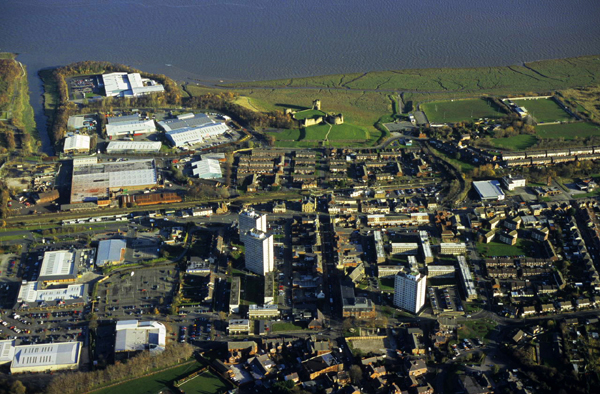
Flint town and castle from the south, with the Dee estuary in the background. The rectangular plan of the medieval town can just be made out in the centre of the photograph, with the broad run of Church Street leading straight to Flint Castle. The castle was originally moated with a link to the tidal waters of the estuary. Most of the medieval town has been overlain by later housing. Photo: CPAT 08-c-200.
|
Edward I succeeded his father Henry III to the English throne in 1274. Political events early in his reign were to have a profound impact upon the history of Flint and indeed Wales as a whole.
One of Edward’s earliest concerns was the reconquest of lands in Wales which had formerly belonged to the Crown and the Marcher lords but which had been regained by the Welsh during the reign of his father and his predecessors. During the course of military campaigns in 1276–1277 Edward successfully reconquered many of these lands but by treaty allowed the Welsh prince Llywelyn ap Gruffudd to retain the core territory of Gwynedd in north-west Wales.
Initially, the primary reason for Edward’s creation of a castle and town on a new site bordering the Dee estuary at Flint in 1277 appears to have been to simply to act as a campaign base for the reconquest of Perfeddwlad – the king’s privately-owned territory along the north coast of Wales. As a young man Edward had already briefly held and indeed visited the territory during his father’s reign, before it was lost to Llywelyn in 1256, just over twenty years before. The events of 1277 have an important bearing upon not only upon the subsequent history of Flint but precipitated the eventual conquest of Wales as a whole.
The royal army advanced from Chester and had established a foothold at Flint by 21 July 1277. Rhuddlan was regained by the end of August, and the war was finally brought to a close in November 1277. Under the terms of a treaty then drawn up, Llywelyn continued to rule west of the Conwy, but the lands to the east were again ceded to the English crown. The inland areas of Perfeddwlad were granted to Dafydd, Llywelyn’s brother, in reward for his support during the war. The coastal areas of Perfeddwlad, potentially of greater strategic and commercial significance, were retained by the English king, who for the next five years pressed on with the development of his reconquered territories, particularly in Tegeingl. Here, building of two new Royal castles at Flint and Rhuddlan, had been started by the autumn of 1277, and their associated fortified boroughs were evidently already in existence by the spring of the following year when land was allotted to the predominantly English incomers who were being encouraged to come and settle in the town. The objectives in this buffer zone between the Welsh and English kingdom were both military and commercial. From the first, Edward’s strategy was clearly intended to regain and hold the territory by means of castles, with fortified market towns as a means of generating income through taxation. For the sake of security and promoting trade they were to be accessible from both land and sea.
A dramatic change of plan was forced upon Edward by the Welsh revolt which stemmed from the growing resentments and injustices resulting from the imposition of English law and custom. The revolt began with the attack on Hawarden Castle by Dafydd and Llywelyn on Palm Sunday in 1282. As a consequence, Edward resolved to bring Welsh independence finally to an end and over the course of the next thirteen years he established castles and boroughs at Conwy, Caernarfon, Harlech and Beaumaris, holding the former kingdom of Gwynedd in a vice-like grip. The focus of English military and administrative interests and expenditure in north Wales had now irrevocably shifted to the west. Having lost their military significance neither Flint and Rhuddlan demanded the elaborate stone town defences around the royal boroughs of Gwynedd. Tegeingl was retained as part of the king’s domain, and in March 1284 Flint became the county town of the newly created shire of Flint. In 1301 the town and castle of Flint were conferred on Edward’s I son – Edward of Caernarfon, Prince of Wales – as part of his earldom of Chester.
The site chosen for the castle and town at Flint was an otherwise possibly little inhabited stretch of land bordering the estuary in the ancient parish of Northop (Llaneurgain) and ancient administrative district of Coleshill. The site was ideal from a number of standpoints: it stood midway between Chester and Rhuddlan and no more than a day’s journey from either, by land or by sea. An isolated rocky headland jutting out from the otherwise featureless southern shore of the Dee estuary provided a secure foundation for the castle. The rocky outcrop is the origin of the town’s name (perhaps made up in 1277) which first appears as le Flynt or le Flynd, probably derived from the English word ‘flint’, simply meaning hard stone or rock. Late in the year of conquest the name was also given in documents as le Cayllou or le Chaylou, from a French word caillou meaning a stone or pebble. It is probably only a matter of historical accident that the town escaped having a French name, as happened in the case of Beaumaris – another of Edward's new castle towns in north Wales.
Excavations at the castle have given some clues about the form of the coastline at Flint at the time of the Edwardian conquest. The castle was built on an outcrop of sandstone and shale overlain by glacial clay which by the 13th century was joined to the mainland, but a narrow tongue of alluvium passing between the castle and town suggesting that at an earlier time it formed a low intertidal island rising up to about 4 metres above sea level. The north-east quarter of the medieval town – from about the line of the railway – was built on alluvium, the remainder being laid out on a gently-sloping terrace of gravel and clay-based glacial till which sloped up to a height of about 5 metres to 14 metres above sea level further inland.
The integrated plan of the medieval castle and town is often held up as classic example of medieval design. The relatively level and undeveloped site imposed few constraints and consequently the scheme that emerged was both innovative and experimental and offers a fascinating insight into what was in the mind of the medieval military strategist and town planner responsible for the works. Considerable expense was needed on the king’s behalf to see through this ambitious enterprise. Consequently, like many of the royal building operations, detailed financial records were kept which tell us in some detail about the building materials that were needed, where they came from, about the workmen employed in building it, and how the money was raised to pay for the work. They also give us an idea of the logistics and organisation involved.
A considerable amount of earth-moving was needed to transform the low rocky headland into a suitably defensible position for the castle. The square inner ward of the castle, defended by the Dee estuary to the north, west and east, has round towers at three corners and a great round keep at the south-east which was probably connected by a moveable bridge across the inner moat. The inner ward was entered by means of a small square gatehouse housing a drawbridge approached by a fixed timber bridge running part-way across the partly rock-cut inner moat which separated the inner and outer wards, the curtain wall of the inner ward rising from the base of the inner moat. The outer ward was separated from the town by a massive rock-cut outer moat, parts of which were also revetted in stone, over 350 metres in length. Further observation is needed to trace the precise course of the medieval coastline, particularly to the west of the castle where land reclamation for industry and the construction of wharves has taken place since the late 17th century, but archaeological excavations have revealed the presence of acorn barnacles on the sides of the outer moat which show that it had been dug to be open to the tidal waters of the estuary. The Dee estuary has a considerable tidal variation, ranging from 10 metres at spring tides to 6 metres at neap tides.
Within a month of the army’s arrival in July 1277 the workforce had swelled to nearly 2,300 including experienced dykers from the Fens. In the early weeks and months the work had to be carried out quickly to be certain of securing the site before the onset of winter – bonuses being paid to the hardest-working barrowers. As well as for defence, navigable channels and wharves were needed for the rafts which ferried stone and other building materials across the estuary from Wirral, the local stone being unsuitable for construction work. Copious amounts of timber were needed, and most of this appears to have been obtained from the native woodlands stretching inland and along the estuary towards Ewloe. helping to clear the land for agricultural use in the process. Initially, the area of the medieval town probably housed the army garrison and workforce, but within a month most of the troops had moved on to the forward base at Rhuddlan, which for the next two or three seasons became the focus of building activity. After this the pace of work on the castle at Flint gradually slackened off but was to continue intermittently for the next twenty years. Despite a reduction in the strategic significance of the castles at Flint and Rhuddlan following the Edwardian conquest of Wales, they evidently continued to act as secure stopping-off points en route to the royal castles further west and on the journey by land and sea to Ireland where Edward also held extensive estates.
Temporary turf revetments and timber palisades at the castle were gradually replaced in stone and as walls and towers were completed carpenters, smiths and plumbers were engaged on finishing roofs, windows, doors, and the building of a bridge between the castle and the town. The final significant expenditure, in the years 1301–03, spanning the end of Edward’s reign and the beginning of his successor’s saw the addition of a ‘noble and beautiful’ timber-built upper storey on top of the great round keep. The Great Tower, considered ‘one of the most puzzling features of any of the Welsh castles’, has drawn parallels with the detached Tour de Constance at the medieval fortified town of Aigues Mortes, the former Mediterranean port from which Edward set sail to the crusades in 1270 and from which he returned to accede to the English crown in 1272. Those involved in the construction of the castle were evidently proud at what they had achieved. The medieval moated garden at Belgrave Moat at Eccleston near Chester, created in the 1280s or 1290s by Richard of Chester – one of the leading military engineers engaged at Flint in 1277 – reproduces at a reduced scale the plan of the inner ward of the castle and its great detached keep.
The medieval town was the most symmetrical of the new towns of medieval Britain, said to be ‘the town which most writers on urban geography and history use to demonstrate the classic features of a castle town’. Thomas Pennant writing about it in the late 18th century – misled by the regularity of the town’s layout and no doubt also by the apparently similar juxtaposition of river, medieval castle and Roman fort on the Dee at Chester – can be excused his mistaken ‘conjecture of the probability of its having been a Roman station’. Recent survey work has revealed the extraordinary symbolic geometry inherent in the plan of the town and castle: the Great Tower, the medieval market hall and the church – representing in turn the Crown, the civic authorities and the Church – all significantly lie precisely on a line which bisects the medieval town.
The layout of the medieval town is known partly from late plans and partly from a limited amount of archaeological excavation but is most clearly shown on John Speed’s maps of the town – a field drawing of 1607 preserved in Merton College, Oxford, a larger map accompanying his map of Flintshire which appeared in his Theatre of the Empire of Great Britaine published in 1610/11 and a smaller one which appears as a cartouche bordering his map of Wales in that volume. The medieval street plan fortuitously survived more or less intact through the period of industrial expansion in the 19th century – but became somewhat masked by the regeneration of the town centre in the second half of the 20th century.
The form of the defences is unique to Flint and Rhuddlan which significantly were started within a matter of weeks of each other in 1277. Flint was rectangular in shape with rounded corners, surrounded by double banks either side of a massive ditch enclosing an area about 225 by 420 metres across, representing about 9.5 hectares, compared with the 10 hectares estimated at Rhuddlan. The only explicit record of expenditure on the town defences consists of payments to diggers working on the town ditch between 1281–83 and 1284–86 which suggests that the town defences were not all built in the first phase of work. Some of this work is described as having been ‘after the war’ and may therefore represent repairs to damage caused during the revolt of Dafydd and Llywelyn in 1282–83 which resulted in Edward’s decision to subdue the whole of Wales, though no deaths are recorded and otherwise only two accusations of theft and the burning of a number of houses are documented.
A single section of the town defences, excavated in the area of Duke Walk and Swan Walk towards the south-west end of Duke Street under emergency conditions before the redevelopment of this part of the town in the early 1970s, showed that the town ditch was about 16 metres wide and 3 metres deep. Nothing had survived of the outer bank at this point but the inner bank, which survived to a height of 0.75 metres, had been about 17 wide at its base, probably having a steep outer face revetted with turf. The inner bank would most probably have been defended by a timber palisade set upon its summit as a protection against arrows, the most potent form of attack at this time, the overall depth of the defences being about 30 to 40 metres. As yet it is unknown whether the town ditch continued across the three entrances, to be crossed by bridges, and whether there were simply gates for protection or whether timber gatehouses were built as seems to be the case at Rhuddlan. The lack of any evidence of ploughing below the excavated section of the inner bank tends to confirm the idea that the town was set out on a largely vacant stretch of land close to the shoreline of the estuary.
Further excavation is needed to determine the precise relationship of the town and castle defences in the area which now lies below Castle Dyke Street. No clear indication of the outer moat of the castle is given by Speed, who somewhat ambiguously shows the inner and outer banks merging into one on the seaward side of the town. The town banks here may simply be represented in perspective, however, a drawing convention which he occasionally used, since there is other evidence that the town ditch continued across this side of the town. Speed’s larger published plan also shows an additional double bank projecting towards the estuary from the town banks to the south-east of the outer moat of the castle, which seems to represent an otherwise unrecorded line of earthworks defending a harbour close to the Great Tower of the castle which seems to been designed to cover not only the entrance to the inner ward but also to command the outer ward and the harbour. Excavations have suggested that part of the outer moat to the south of the Great Tower was used as a castle wharf. Speed’s field drawing of Flint and the smaller plan of the town published in his Theatre of the Empire of Great Britaine shows an additional gap in the town defences at this point, suggesting a second wharf on the outer edge of the castle moat, possibly of medieval origin, directly accessible from the town and lying roughly in what is now the area of the playground and car-park at the eastern end of Castle Dyke Street. The goods being shipped to and from the town in the early years appear to have been many and varied, including, for example, a cargo of fresh bread from Chester lost at sea in 1283 and 140 tons of lead sent by sea to Conwy in 1286.
The symmetrical medieval street pattern in the town is clear from Speed’s map which shows the main coastal road – corresponding to the modern Holywell Road and Chester Road – crossed at right-angles by a grid of four parallel roads, two to either side of the medial line bisecting the Great Tower of the castle. The roads seem to have been accurately surveyed, probably in the units of measurement such as rods, chains and furlongs that were in use at the time. One of the four parallel roads – corresponding to the modern Church Street – was aligned upon the gatehouses of the inner and outer wards of the castle at one end and the main road south of the town at the other. Access to the castle had to be made via the town, thus giving it an extra layer of defence. Speed’s plan shows a number of other roads and lanes, notably running just inside the inner bank and just outside the outer bank. The excavation of a section across the defences in the 1970s mentioned above suggests that these partly overlay the medieval banks and were therefore later in date, but further excavation is needed to be certain of this.
Evidence still buried in the ground also has much to tell us about what the town was like, about the kinds of buildings that existed and the way of life of the inhabitants. The more certain elements of the medieval town are the town church and the town hall. The church was dedicated to St Mary,and continued as a dependent chapel of Northop church for many centuries to come, on a site occupied by its present-day successor. The town hall was adjacent to the market place, where the present town hall was later built. The town was clearly up and running by early in 1278 when a weekly market and annual fair were proclaimed and when agents were appointed to rent out plots of land to would-be inhabitants, even if the defences had still to be completed. The town received its first royal charter in 1284 conferring full borough privileges and rights to land. A second charter in the same year granted rights to timber and pasturage in the woods of Northop, Leadbrook, Kelsterton, Wepre and Soughton, stretching a further 3–4 miles to the south and east. In line with the practice elsewhere the constable of the castle was also the mayor of the town. Until perhaps the 17th or early 18th century a majority of buildings in the town, with the possible exception of the church, are likely to have been of half-timbered construction with wattle-and-daub infill panels and roofs of thatch or reed.
A valuable insight into the origin and occupations of early settlers is given by documents of the 1290s which list the names and occupations of between 70–80 householders. Of these, all but five appear to be English incomers, and at least a quarter are identifiable as tradesmen or craftsmen engaged at one time or another upon the king’s works at Flint and elsewhere. The names include a clerk, several tailors, several tanners, a butcher, a cobbler, stone masons, a harrower, carpenters and sawyers, blacksmiths, a plasterer, a driver, an iron and steel merchant, a miner, a lead-worker, several millers, a lime-burner, a glazier, and a salt-maker, though as usual at this period the names of the women who played an vital role in the life and economy of the community are not listed. They had been drawn to Flint sometimes singly and sometimes several brothers together from wide area of England including Cheshire, Merseyside, Staffordshire, Hertfordshire, Bedfordshire, Hereford and London as well as more locally from Coleshill despite continuing friction between incoming and indigenous communities in the area. Intolerance was not limited to the English and Welsh, however, since in common with most other town charters issued at this period, those of Jewish descent were forbidden to take up residence.
The take-up of tenancies appears to have been slow, however, since in 1282 agents were authorized to rent out plots in the town free of charge for ten years and at a reduced rate thereafter. The extent to which Flint ever became built up during the medieval period is open to question. Speed’s map of the town in 1610 shows many vacant plots within the town, but the extent to which this represents abandonment or simply a failure to develop from the start is uncertain. Ordnance Survey maps of the town in the 19th century show the town to be subdivided into many more property boundaries than are shown by Speed, but the extent to which these might mirror medieval burgages or a much later process of subdivision is again unclear. Though craftsmen and merchants were important to the livelihood of the town most of the inhabitants were firmly rooted in the agricultural economy: the free plots within the town on offer in 1282 came with 40 acres of agricultural land attached. The location of many of the early industries suggested by the occupations of the inhabitants is unknown, though there was a watermill at Atiscros (Adescrossmulne) in 1358.
Near disaster struck the town in September 1294, just ten years after its first charter, when it was deliberately set on fire on the orders of the constable of the castle during the Welsh revolt in north Wales. The revolt was led by Madog ap Llywelyn, in response to perceived injustices and unfair taxes. This desperate measure by the constable, though by no means unparalleled, was designed to protect the castle and hinder the Welsh from laying siege to it. It appears to have involved the destruction of 73 or more buildings – perhaps every building in the town, with the possible exception of the church, where some personal possessions appear to have been stored. The townspeople were compensated for their losses and houses were rebuilt, though the episode can have done little to encourage a rush of newcomers to come and settle in the town. As well as the losses claimed by a number of tradesmen, such as the stock in trade of a tanner, many of the goods compensated for were significantly of an agricultural nature, including corn, hay, and varied livestock such as cows, oxen, horses, sheep, chickens and pigs. Madog’s revolt was harshly dealt with by measures which further restricted the social and economic opportunities of the Welsh in and around the borough. Racial tensions continued well into the fourteenth century, and although the offices of constable of the castle and sheriff were granted to two Welshmen by Edward III in 1350, this was only on the condition that an Englishman was retained as under-constable, ‘because we will that the same castle be kept by none other than an Englishman’.
The boundaries of the medieval borough of Flint included what later became the parish of Flint together with the township of Coleshill Fawr in the parish of Holywell, an area of land extending to Oakenholt to the east, Flint Mountain to the south, and Gadlys in the west. There is good evidence that a substantial part of this area was systematically felled of timber, cleared and turned into open fields in the later 13th century at the time the town was founded, to provide agricultural land for the townspeople. The authority for carrying this out is clearly stated in the town charter granted by Edward I which states that ‘all the lands now assigned to the borough should be entirely diswarrened and deforested’. A further charter by Edward specifically granted the right to timber for smelting lead ore and for animal grazing.
The Flint Tithe map of 1839 shows that in the 19th century the town was encircled on the landward side by a distinctive grid-like pattern of elongated fields mostly running up and down the slope of the hill and clearly laid out in relation to the medieval town. These fields were clearly created as the result of a rapid period of landscape reorganisation at the time of the Edwardian conquest and are quite distinct from the more irregular field patterns that surround them. Much of this fieldscape has been built over as the town developed as an industrial settlement during the later 19th and 20th centuries, and became increasingly divorced from its original rural context. Some of the original field pattern survives, however, in the ‘green barrier’ south of the town designated in the Flintshire Unitary Development Plan, and by occasional green spaces and the pattern of footpaths and roads such as Coed Onn Road/Allt Goch Lane which have fossilized the pattern within the modern settlement boundary.
This distinctive pattern of fields, interleaved by lanes and footpaths has resulted from the gradual amalgamation and enclosure, most probably during the course of the 15th to 17th centuries, of former medieval open fields worked by the medieval townspeople. These fields were originally much narrower and individually worked strips about a furlong (220 yards = 201 metres) in length and often no more than about a rod (16.5 feet = 5 metres) in width simply divided from each other by unploughed baulks. The charter issued by Edward III in the 1360s interestingly defines part of the borough boundary at that time with reference to ‘selions’ (medieval open field strips) and headlands in the Leadbrook area to the east of the town. In places, traces of these individual fields have survived in the form of ridge and furrow which was perhaps once much more common, ‘run-rig’ (another term for ridge and furrow) being noted by agricultural commentators to have been common in the Flint area in first decade of the 19th century. Other distinctive features of this former agricultural landscape are the characteristic reversed-S outline of the fields and the headlands running along the contour at the top and bottom of a run of fields (later often occupied by lanes) where the plough-teams turned. Today a high proportion of the fields around the town form permanent pasture, but it is evident from the 1837 Tithe map that there was formerly a much higher percentage of arable land within close proximity to the town.
A total area of about 440 hectares (1090 acres) of former open field can be identified around Flint on the Tithe Map, which at a rough calculation of the 40 acres per householder on offer in 1282 suggests that the population of the town in the late 13th century included up to about 30 farming families. There is no evidence to suggest that the individual strips were assigned by lot from season to season as was the custom in English villages during the Middle Ages since by the nature of the settlement it seems more likely that from the beginning fields were rented out or leased from the borough.
Topography and field-names help to reconstruct further elements of the former countryside around the medieval town. The distribution of individual strips suggests that they may have been divided into at least two open fields which may have been farmed on a rotational basis – one to the south and east of the town in the township of Flint and one to the west and south-west of the town in the township of Coleshill Fawr. A number of the fields to the east of the town appear on the Tithe with the field-name ‘Maes y dre’ (town field), suggesting the name of one of the open fields. Other field names suggesting open field origin include the Welsh element maes (open field) and the English accar (acre) and ‘quillet’. A group of fields close to the coast had the name ‘Safurlum’ possibly meaning ‘sea furlong’. The pattern of open fields avoids the slightly broken strip of land either side of the Swinchiard Brook running south from the medieval town and loosely corresponding to the angle between the Halkyn Road and the Northop Road which probably survived as unenclosed common during the medieval period, providing rough grazing for animals and also free access to the hill land further south. Here there is a different suite of field-names on the Tithe Survey, including elements derived from the Welsh gweirglodd and coed and the English ‘green’, between them denoting meadow, recently colonised woodland and unenclosed common. It is probably also significant that the stream itself includes the English element swin meaning ‘swine, pigs’. Areas of common grazing were also undoubtedly exploited on the lower-lying ground of Flint Marsh just to the west of the town and along the salt marshes bordering the estuary before widespread reclamation and enclosure began in the early 18th century.
In the late thirteenth century Flint had become the most prosperous town in Flintshire but for various reasons its fortunes were to gradually decline over the course of the next two or three centuries, a period during which some snippets of information provide a general picture about the town and its inhabitants. The plagues which swept the country in 1349 and on a number of further occasions during the second half of the 14th century had the general effect here as elsewhere in stunting productivity and growth, a diminishing workforce having an inevitable impact upon social, industrial and agricultural organisation. In the countryside around the town these pressures probably resulted in the gradual amalgamation and consolidation of individually cultivated selions and the break-up of the open field system initiated during the later 14th and 15th centuries by the sale of land to private owners and perhaps increasingly to farmers living outside the town. The percentage of Welsh field-names is higher in Flint than in many of the parishes of eastern Flintshire and, though lower than those in the west, it suggests that a gradual shift in the balance of ownership of land was taking place from exclusively English speakers to native Welsh speakers.
As well as the support provided by farming some income continued to come in for repair work on the castle which regularly appears in the royal accounts for the years 1328–52 and 1422–37. A new hall was built in 1382–83 ‘within the castle, of Flint in which pleas may be heard by the king’s justices’. The castle continued to have a role as a stopping-off point on journeys by land and sea to Ireland, a role which lies behind several notable historical events involving ill-fated English kings during the 14th century – the meeting at the castle of Edward II and his friend and possible lover Piers Gaveston in 1311 and Richard II’s presence here in 1399 shortly before his forced abdication in favour of the future Henry IV.
Flint was one of the English towns in north-east Wales attacked by the supporters of Owain Glyn Dwr in September 1400, who laid siege to the castles at Flint, Rhuddlan and Hawarden in early August 1403. Flint Castle was still sufficient to provide a place of refuge for the townspeople, it being said that they ‘dared not linger outside the castle’. The town itself escaped destruction though a mill at Flint was destroyed and the fields of the townspeople were said to lie uncultivated. The town was evidently slow to recover and consequently no rents were collected in 1407 and 1409 ‘because of the depredations they had suffered and the poverty of the burgesses’. But repairs and new building works were eventually undertaken: the destroyed mill was rebuilt in 1412, and in 1452 a new hall and chamber were built at the castle. Maintenance of both the castle and town ditches was difficult without a large workforce to hand and there is evidence from the excavations at the castle that silting was becoming a serious problem. The inner moat probably began to dry out by the end of the fourteenth century, and by the 15th century the outer moat had become inaccessible to tidal waters.
A rare glimpse of the cultural life of Flint at the very end of the Middle Ages can be gained from a poem by Ieuan ap Tudur Penllyn written in about 1480 which, in satirizing an English marriage feast in general and an English bagpipe player in particular, perhaps reveals something of the ethnic tensions which still survived more than two centuries after the conquest. The poem provides some incidental detail about the topography and economy of the town. The place is mockingly called ‘a double-walled town, lop-sided’ (I dre ddwbl, gaergwbl-gwyrgam); the participants in the marriage feast are derided as ‘dealers in barley and wheat’ (borthmyn haidd ac yd); and the town is welcome to keep ‘its furnace’ (ei ffwrn).
Privacy and cookies