Cymraeg / English

|
Back Home |
|
|
Elan Valley Historic Landscape |
Historic Landscape Characterisation
The Elan Valley
ENVIRONMENTS, BOUNDARIES AND PERCEPTIONS
The Natural Environment
The rocks underlying the Elan valley historic landscape area are mostly composed of Silurian and some Ordovician shales, slates, mudstones and siltstones, together with beds of conglomerate. During the last Ice Age, between about 70,000 and 12,000 years ago, the area became submerged beneath a glacial ice sheet which had a considerable impact upon the present-day topography. Distinctive features of this period of glaciation are the smoothed and flattened upland plateaus, steep-sided, U-shaped glaciated valleys, morainic deposits, and hillside terraces and platforms where glacial meltwater has cut through the layers of stone debris deposited by glacial action. Glacial action disrupted the flow of the river Ystwyth which originally fed a lake in the area of Gors Lwyd, in the watershed between the Ystwyth and Elan, which in turn fed the river Elan, a tributary of the river Wye.
The historic landscape area falls into a number of distinct topographic areas which are closely reflected in the historic landscape character areas defined below. To the east is an undulating lowland area, mostly between 190–250m above sea level, extending from Rhayader to Elan Village and bounded by the mountains to the west and the river Wye to the east.
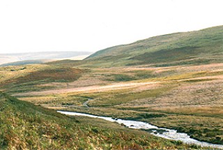
The lowest dam, at Caban-coch, was built at a natural bottleneck in the Elan valley, between the steep slopes of Craig Gigfran to the north and Craig Cnwch to the south. Formerly, the Elan and Claerwen joined about a kilometre upstream of the dam, the two rivers then diverging and snaking their separate ways into the moorland of Elenydd for a further 20 kilometres in the case of the Elan and 15 kilometres in the case of the Claerwen. The southern part of the moor is drained by tributaries of the Irfon, itself a tributary of the Wye, and the western part of is drained by the Ystwyth to the north-west, the Teifi to the west and the Tywi (Towy) to the south-west. Before the creation of the reservoirs the Elan and Claerwen occupied steep-sided and relatively fairly flat-bottomed valleys, often less than half a kilometre across, the floor of the valley rising from a height of about 250 metres above Ordnance Datum near their confluence to just under 400 metres in their upper reaches.
Characteristic U-shaped glaciated valley of the upper Claerwen.Photo: CPAT 1526.29.
The moorland of Elenydd, which forms the central portion of the Cambrian Mountains, is dissected into three rough blocks by the river valleys. The southern part of the moor, to the south of the Claerwen valley, is the generally higher and more remote, with extensive upland plateaus at heights of between 400–500 metres and with peaks like as Drum yr Eira, Drygarn Fawr and Pen y Gorllwyn reaching over 600 metres from which both Cardigan Bay and the Brecon Beacons are visible on a clear day. The western part of the moor, between the Elan and Claerwen, again has extensive plateaus with somewhat lower peaks such as Bryn Garw, Trumau and Graig Dyfnant just over 500 metres high. The eastern part of the moor, overlooking the Wye valley, is generally lower though with a few peaks such as Moelfryn and Crugyn Ci of over 500 metres.
Two further distinct topographical areas in the study area are Carn Gafallt, an isolated upland block to the east of Elan Village and Cwm Dulas, a steep sided valley on the southern side of Carn Gafallt drained by a further tributary of the Wye.
The soils in the lowland area of Cwmteuddwr between Rhayader and Elan Village and in Cwm Dulas are generally well drained, fine loamy and silty soils with deeper silty alluvial soils, in places overlying gravelly subsoils, on the flatter land bordering the Elan. Similar soils would formerly have existed in the valley bottom along the lower Elan and Claerwen valleys before the construction of the reservoirs. The small lowland lake of Gwynllyn, to the north-west of Rhayader, has resulted from impeded drainage caused during the last glaciation. The soils on the steep slopes margins of the valleys are generally well drained fine loamy and silty soils, with enclosed fields on some of the flatter areas free of rock outcrops and screes. The Elenydd uplands are principally covered with blanket and basin peat up to 3 metres deep, with areas of loamy upland soils.
The blanket bogs on Elenydd are dominated by sphagnum, cotton grasses and heathers with bog pools and larger clear-water lakes such as Llyn Gynon, Llyn Fyrddon Fawr and Llyn Fyrddon Fach, especially on the northern and western areas of the moor. The lakes, which have formed since the last glaciation, are exceptionally up to 25 hectares in extent and some support populations of brown trout and other fish species. Drier moorland areas on the thin free-draining acid soils beyond the extent of the blanket bogs support a grassy heathland vegetation with bell heather, bilberry and gorse. These upland areas have traditionally provided grazing land of poor to medium quality, exploited during the summer months, and have seen little management other than for the purposes of wildlife conservation in some areas.
The free-draining soils on the more steeply sloping stream and river valleys such as in the lower Elan and Claerwen, in Cwm Dulas and on the eastern slopes of Elenydd overlooking Rhayader, support areas of broadleaved woodland often dominated by sessile oak or by ash in the case of ravines or more rocky slopes, together with heathers and gorse. The less steeply sloping ground in these areas have generally been cleared of natural vegetation and enclosed, perhaps from the medieval period, to create grassland of moderate quality. Some of these areas were planted with conifers, on a smaller scale in the early 19th century but more extensively when the reservoirs were created in the later 19th and earlier 20th centuries.
The well-drained soils on the flatter ground along the unflooded areas of the lower Elan and Claerwen valleys and in the lowland area between Elan Village and Rhayader are almost exclusively maintained as grassland today, though historically they are likely to have been used for the production of cereals and root crops as well as for grazing.
A picture of the vegetational and hydrological change of the Elenydd uplands and the surrounding valleys has been provided by analysis of peat deposits at the head of the Elan valley, at Llyn Gynon (Cardiganshire), in a valley to the north of the Claerwen reservoir at Esgair Nantybeddau, and at upland plateau sites at Pwll-nant-ddu, between Claerwen and Penygarreg and Bryniau Pica to the west of the Claerwen reservoir. These studies have shown that by about 8500 BC, following the end of the last Ice Age, that birch woodland became established over much of the area, with some willow perhaps on damper ground and sedges and grasses forming open heathland perhaps in some areas of high altitude. From about 8200 BC there was a rapid spread of hazel together with the beginnings of mixed broadleaved woodland, including oak and elm, possibly at all but the highest altitudes. Fragments of charcoal appearing in the peat deposits suggest the first indications of human activity in the period about 7500 BC, during the Mesolithic period. From about 6200 BC there was an increase in alder pollen, suggesting the onset of damper conditions and by about 5000 BC there was a transition to more open conditions with a rapid rise in heather, grass and sedge heathland, with continuing evidence of human activity spanning the late Mesolithic and earlier Neolithic periods possibly initially representing the hunting of game animals and later grazing by domesticated flocks. More extensive woodland clearance was taking place during the later Bronze Age, from about 1200 BC and there is some evidence to suggest cultivation at this time and during the subsequent Iron Age. By the later 1st century BC and the 1st century AD the pattern of vegetation had probably come to closely resemble that visible today. There is further evidence for the subsequent intensification of forest clearance affecting particularly alder, oak and birch woodland probably in the lower valleys which it is argued took place during medieval times and accompanied with evidence of pastoral activity representing an intensification of grazing in the area following the establishment of monastic granges of the Cistercian monastery of Strata Florida in the later 12th century.
Administrative Boundaries
During the earlier medieval period the greater part of the study area, to the north of the Claerwen, fell within the commote known as Cwmwd Deuddwr, (contracted to Cwmteuddwr) which derived its name from the two rivers Wye and Elan. The area to the south of the Claerwen fell within the commote of Dinan in the cantref of Buellt, which subsequently formed the hundred of Builth in Breconshire.The western part of Cwmteuddwr fell within the commotes of Mefenydd and Pennardd which subsequently became the hundreds of Ilar and Penarth in Cardiganshire. From between about the 7th to earlier 10th centuries Cwmteuddwr had formed part of the kingdom of Powys, but in the later 10th and early 11th centuries it formed part of a separate territory between the Wye and Severn, known as Rhwng Gwy a Hafren which along with the kingdom of Brycheiniog showed allegiance to the royal house of Deuheubarth of south-west Wales.
From the end of the 11th century and throughout much of the 12th century ownership of the commote of Cwmteuddwr was to be disputed by the royal house of Deuheubarth and the Anglo-Norman marcher lords. Skirmishes between the Mortimers and Rhys ap Gruffydd (The Lord Rhys) had already occurred by 1176 when Rhys’s two sons-in-law, Morgan ap Meredith and Einion Clyd, Lord of Elfael were ambushed and killed in the woods of ‘Llawr Dderw’ near Rhayader in Cwmteuddwr. Rhys later invaded the territory and established the castle at Rhayader in 1177. In 1184 the greater part of the commote of Cwmteuddwr was amongst the extensive tracts of land that Rhys granted to the newly founded Cistercian monastery at Strata Florida, of which Rhys was the principal benefactor. The grant was made to the abbot of Strata Florida, before Rhys’s army, in the church of St Bridget at Rhayader. Rhys retained a small area of the commote, known as the manor of Cwmteuddwr, in the immediate vicinity of Rhayader, for the defence and provisioning of Rhayader castle. The part of the commote comprising Elenydd and the Elan valley became known as the manor of Grange.
Within a matter of a few years Cwmteuddwr fell into the hands of the Anglo-Norman Mortimer family, following which Cwmteuddwr came to form part of the marcher lordship of the cantref of Maelienydd. On the accession of Edward IV in 1462 it became a crown manor, and remained such until 1825 when it was sold. At the Act of Union of 1536 the former Mortimer commotes of Cwmteuddwr and Gwerthrynion were formed into the hundred of Rhayader in the county of Radnorshire.
Today, the eastern parts of the study area largely falls within the communities of Rhayader and Llanwrthwl, together with parts of the communities of Llanwrtyd Wells, Treflys and Llanafanfawr, in the county of Powys, created in 1974 by the amalgamation of Radnorshire, Breconshire and Montgomeryshire. The western part of the study area falls within the communities of Ysbyty Ystwyth, Ystrad Fflur and Tregaron in the county of Ceredigion.
The Grange of Cwmteuddwr was purchased in 1792 by a Wiltshire gentleman, Mr Thomas Grove, in 1792 who set about developing the estate. After changing hands several times the area of the grange within the watershed of the Elan and Claerwen rivers was acquired by the corporation of Birmingham in 1892 for the construction of the reservoir scheme, upon which work began in 1893. Responsibility for the reservoirs and the Elan Estate passed to Welsh Water in 1974 following the creation of privatized water companies, and remains the largest single area owned by a water company in Britain. In 1989 the Welsh Water Elan Trust was established, with responsibility for protecting the natural environment of the estate and encouraging public access and understanding. The southern part of Elenydd in Breconshire, known as Abergwesyn Common, now belongs to the National Trust. Carn Gafallt, a small separate upland area to the east, also in Breconshire, was purchased by the Royal Society for the Protection of Birds from the Glanusk Estate in 1983.
In ecclesiastical terms most of the study area fell within the medieval parishes of Llansantffraid Cwmteuddwr and Llanwrthwl within the deanery of Buellt, in the diocese of St Davids.
Early Perceptions of the Landscape
Early accounts of journeys by people travelling through the area, early maps and records of place-names provide a record of how the landscape of the Elan valley was described and perceived in the past by those who lived within it or visited it.The mountainous area surrounding the head of the Elan has been known as Elenydd since early times. The name is probably being derived from the name of the river Elan with the ending -ydd, which implies ‘the area of’ to the name to which it is attached. It is first recorded in Gerald of Wales’s Journey through Wales, composed in 1188s, in which (in translation) he describes ‘the lofty mountains of Moruge, called Elennith in Welsh’. Gerald highlights Elenydd and Eryri (Snowdon) as the two principal mountain ranges in Wales and explains that the English name ‘Moruge’, a form otherwise unrecorded but probably derived from a word similar to the French marais (‘marsh’), relates to the marshlands on its summit. The name therefore has the meaning the ‘Marsh Mountains’, to distinguish it from the English Snowdon, the ‘Snow Mountains’. Gerald was accompanying Archbishop Baldwin’s journey through Wales, urging the faithful to join the Crusades, this particular leg of the journey being between Strata Florida abbey and the church at Llanbadarn Fawr. The Elan valley itself is first recorded as Glan Elan in the late 12th century and subsequently as Dyffryn Elan (Driffyn Elan).

Llyn Cerrigllwydion Isaf, one of the large upland lakes on Elenydd. Photo: CPAT 03-c-0647.
A visit to the area, again in connection with Strata Florida, was made in the 1530s by John Leland, the king’s antiquary, who explored the countryside around the abbey, no doubt with local guides. He visited Llyn Teifi and the other pools on the western side of the moor, noting that they were ‘plentiful of trouttes and elys’. From a point two miles beyond the lakes he surveyed a scene that can have changed little since the 16th century: ‘I standing on Creggenaugllin [Carregyderlwyn?] saw no place within sight, no wood, but al hilly pastures’.
Further across the moor he reached, ‘Llyn y vigin velen’ (Llyn y Figyn), a name which he translates: ‘Y vigin is to say a quaking more. Velin is yellow’. The lake he says is ‘the colour of the mosse and corrupt gresse about it’. From here he went on to ‘Llin creg lloydon’ (Llyn Cerrigllwydion), presumably then taking the route known as the Monks’ Way on towards Rhayader. Just as today, it was the wildness and remoteness of the area which the visitor remarked upon: ‘Al the mountaine ground between Alen [Elan] and Strateflure [Strata Florida/Ystrad Fflur] longeth to Stratefleere, and is almost for wilde pastures and breding ground’.
The first maps of the area began to be published in the 17th century though little detail of the area is generally given. Morden’s map of South Wales published in Camden’s Britannia of 1695 it is simply marked as ‘Gwasted’ (gwastad, ‘waste’). Early 19th-century maps show a number of scarps around the head of the Elan and Claerwen, an area which at this date was often referred to as ‘Cwm Toyddwr Hill’, named after the parish of Cwmteuddwr.
Country ‘seats’ started to be shown on maps published from the early 18th century onwards, Cwm Elan being shown on Bowen’s New and Accurate Map of South Wales first published by subscription in 1729 (Hugh Powell of Cwm Elan being one of the subscribers). Both Cwm Elan and Nantgwyllt houses are shown on Thomas Kitchen’s map of Radnorshire of 1754 and on 1813 edition of Coltman’s Map of South Wales.
Privacy and cookies