Cymraeg / English

|
Back Home |
|
|
Elan Valley Historic Landscape |
Historic Landscape Characterisation
The Elan Valley
LANDED ESTATES AND AGRICULTURAL IMPROVEMENTS OF THE 18th AND 19th CENTURIES
The 18th- and 19th-century history of the Elan valley is dominated by the landed estates and gentry houses that had emerged during the course earlier centuries, focused in particular on the gentry houses that had arisen at Nantgwyllt and Cwm Elan.
The Nantgwyllt estate had passed from the Howells (by now anglicized to Powells) to the Lewises and the Lewis Lloyds and continued to expand, the 18th century witnessing the acquisition of such properties as Cnwch, Cwm Esgob and Perthi Llwydion (Perthyllwydion), and the construction of the small proprietary church serving the estate at Nantgwyllt. A number of the older estates were to be purchased and developed as investments by ‘gentleman farmers’ formerly unconnected with area. The Grange of Cwmteuddwr was purchased by Mr Thomas Grove of Ferne House, Donhead St Andrew, Wiltshire in 1792 from John Jones of Hafod. Grove was described by his contemporary, the Radnorshire historian, the reverend Jonathan Williams, as ‘a Wiltshire gentleman, who purchased 10,000 almost worthless acres, which he is now converting into a paradise’. The estate was no doubt attractive on a number of grounds: Cwm Elan could be made an attractive summer residence, away from the family seat in south-west Wiltshire; its wild scenery of mountains and waterfalls had become fashionable; it offered a challenge in agricultural terms of introducing new farming policies for increased productivity; and it presented opportunities for hunting which would have been attractive to a keen huntsman such as Grove. There was also the prospect of revenue from lead mining which was proving profitable just across the hill in Cwmystwyth.
In the early years of the 19th century Cwm Elan is described by Jonathan Williams as being
‘situated on the left bank of the Elan, in a narrow vale, surrounded by the hills, some of which are inclosed and cultivated, and studded with convenient farm-houses seated at proper distances, whilst others are entirely covered with groves of oak from their summit down to the waters-edge’.
Indeed, so impressive was the scenery that Jonathan Williams himself considered that ‘nor is there another parish in this county or perhaps in the Principality itself, that can exhibit more romantic scenes of Nature than those well wooded, watered, and rocky yet fertile districts’.
The agricultural improvements being introduced by landlords such as Thomas Grove are alluded to in the blank-verse poem of 350 lines entitled ‘Coombe-Ellen’ (Cwm Elan) published in 1798 by William Lisle Bowles, embracing the romantic movement of the late eighteenth and early nineteenth century. In the words of Desmond Hawkins, ‘the poem reaches a climax when the poet ends his contemplation of the awesome solitude and pristine beauty of untouched Nature with the thought that human cultivation can further enhance the scene’, probably to be taken as a reference to the new arable rotation and clover which were being introduced by improving farmers and landowners at this period:
. . . . . . . . . ‘here I bid farewell
To Fancy’s fading pictures, and farewell
The ideal spirit that abides unseen
‘Mid rocks, and woods and solitudes. I hail
Rather the steps of Culture, that ascend
The precipice’s side. She bids the wild
Bloom, and adorns with beauty not its own
The ridged mountain’s tract; she speaks, and lo!
The yellow harvest nods upon the slope;
And through the dark and matted moss upshoots
The bursting clover, smiling in the sun.
These are thy offspring, Culture!’
Thomas Grove of Cwm Elan was to become one of Walter Davies’s local correspondents in his report on Agriculture and the Domestic Economy of South Wales, published in 1815 on behalf of the Board of Agriculture. Indeed, on Davies’s first visit to Radnorshire in 1802, he entered the county via Cwmystwyth and headed straight for Cwm Elan, describing Groves as ‘an improver on the Wiltshire system’, then taking in the estates at Nantgwyllt and Noyadd before proceeding to Rhayader. Notes compiled by Davies make references to some of the improvements that Grove had introduced to sheep farming, including the folding his flock and the crossing of native breeds with the Southdown. He also noted the lead ore discovered and being worked on Grove’s estate. The property was transferred to his son, Thomas Grove junior before about 1809 when he succeeded his father as High Sheriff of Radnorshire. The son, like his father before him, continued to make Cwm Elan his residence for about three months each summer, and maintained the agricultural improvements that his father had set in train. In 1811, Walter Davies noted with some relief that the rumours suggesting that the Cwm Elan estate had deteriorated since the son had taken over were unfounded.
The folding of sheep introduced by Grove upon his estate in the late 18th and early 19th century may have involved the enclosure of selected areas of the moorland and the grazing of crops grown for fodder, perhaps including the ‘bursting clover’ referred to by Bowles, which would have had the advantages of improved nutrition for the livestock, controlling breeding, and improving soil fertility through manuring. These and other improvements had become commonplace towards the end of the 19th century. The Reverend R. W. Banks, writing of Cwmteuddwr in 1880 noted that although the intermixing of herds legally prevailed ‘the practice has been for each tenant to secure a distinct sheep walk and maintain his rights on it by keeping a strong flock, with as little change of sheep as may be’. Writing in about the first decade of the 19th century, Jonathan Williams praised the quality of the animals produced by the local farms:
‘many boast of a produce and stock scarcely to be surpassed for quality and usefulness in any part of the county. The sheep of this parish, which depasture upon the hills the whole of the year, are second to none in the Principality of Wales for symmetry of form, and a sound constitution; and the flavour and delicacy of their flesh are not surpassed by English venison, whilst their wool is admired for its fineness and sought for by the manufacturers of cloth’.
Until about the middle of the 18th century the wool from the district was probably processed locally, but after that date is probably supplied the burgeoning woollen industry in Newtown and Welshpool in the Severn valley in Montgomeryshire.
Most of the cattle in Cwmteuddwr at this period were kept ‘to supply the demands of the dairy’, and significantly a number of farmhouses such as Ciloerwynt were extended in the 18th century to include a separate dairy. Jonathan Williams acknowledged that the ‘small black and brindled cows, the aboriginals of this part of the county . . . have of late years undergone great improvement’ by crossing with Shropshire and Staffordshire breeds, but he was critical of the introduction of beef producing breeds such as the Hereford which (though disputed by other contemporary writers) he considered were ‘ill adapted to contend with the frequent inclemency of the weather, or to thrive with a scanty herbage, or in short to fulfil those purposes to which the climate of this county and the nature of the soil are more peculiarly adapted’.
The period from the 18th to the 20th centuries throughout Wales, however, witnessed an increasing emphasis upon sheep farming and a lessening in importance of lowland cattle farms and upland dairies alike. Longhouses with a byre became redundant, being replaced, if at all, by separate farmhouses and cattle sheds. The more inhospitable hafodydd and lluestau were abandoned, flock management on the Elenydd moorland during this period being marked by the erection of drystone sheepfolds, often with multiple pens, by occasional sheep shelters and by small drystone shepherds huts and shelters, sometimes built out of the ruins of the earlier summer houses. Shearing was carried out at the lowland farms in the spring, various of the larger farms and estate centres such as Nantgwyllt having barns where the wool was stored before being sold to dealers. This is possibly amongst the buildings shown in a drawing showing shearing under way in Eustace Tickell’s book, The Vale of Nantgwilt, published in 1894.
Early Woodland Plantations
Ordnance Survey maps of the later 19th century identify a number of relatively small woodland plantations on the sides of the Claerwen and Elan valleys, that were no doubt amongst the investments being made by landlords and tenants from the late 18th century onwards. Eustace Tickell’s 1894 essay, published just before the flooding of the valleys describes Nantgwillt as being ‘backed by wooded slopes of oak spruce and larch, interspersed with towering groups of Scotch fir’, which are also shown sketches which accompany his essay, some of these plantings evidently having been ornamental.
Hunting
The landscape being developed by some of the larger landowners in the area in the later 18th and earlier 19th century was also taking the huntsman into account. William Lisle Bowles’s poem, referred to above, seems to alludes to Thomas Grove’s love of hunting:
‘All day, along the mountain’s heathy waste,
Booted and strapped, and in rough coat succinct,
His small shrill whistle pendent at his breast,
With dogs and gun, untired the sportsman roams’.
Hunting was a pursuit shared by other gentry of the area. One of the sons of the Lewis family of Nantgwyllt was to be commemorated in the popular early 19th-century hunting song ‘Cwn Squeir Lewis Nantgwillt’ (‘The hounds of Squire Lewis of Nantgwyllt’). Jonathan Williams noted that ‘grouse, both of the black and red species’ were to be found on the moorland, and though little effort appears to have been made in developing a shooting estate in the area at this date a number of former shooting butts are to be seen on the Elenydd moorland which may belong to this period.
Rabbit Farming and Crop Cultivation in the Uplands
Further agricultural innovations that may have been introduced to the area by go-ahead farmers and landowners such as Thomas Grove intent on enhancing their revenue from the land are the groups of artificial rabbit warrens or ‘pillow mounds’ and areas of ridge and furrow to be seen on parts of the moorland of Elenydd.
An impressive group of eight pillow mounds is to be seen on Esgair y Ty, just to the west of Pont ar Elan. A number of the mounds are up to about 40 metres long, 6 metres wide and a metre high, and clearly represent a significant investment by landlord or tenant. Further groups of mounds are to be seen near Glanhirin farm and near Aber Glanhirin farm, respectively about 1.5 and 3 kilometres further to the west. Two further mounds are known on the saddle between Esgair Dderw and Penrhiw-wen, closer to Rhayader. Excavations elsewhere have shown that mounds of this kind were constructed with artificial burrows entering from the sides, which would enable rabbits to be periodically culled with the help of ferrets, to be marketed for both their meat and skins. Artificial rabbit warrens were being built as early as the medieval period, but here it seems more likely that they are post-medieval in date. A concentration of other similar groups of pillow mounds in Radnorshire and in Breconshire has suggested that they may have supplied markets in the expanding industrial towns of south Wales and the Marches. Their siting, near the turnpike road across the moorland, would have helped in getting produce quickly to market.
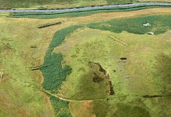
Former cultivation in the uplands is represented by a number of discrete areas of narrow ridge and furrow some of which has only been identified quite recently as a result of aerial reconnaissance. Some of the ridging is to be found in the same general area as the pillow mounds, as for example on the southern slopes of Esgair y Ty and within the area of the encroachment at Aber Glanhirin. Other areas of ridging are known near the encroachment at Lluest-pen-rhiw and on the slopes of Moelfryn (on the hills above Nannerth), on Cefn Gwair (west of the Craig Goch reservoir), on Cefn Cwm (east of Craig Goch reservoir) and in various places on Carn Gafallt (to the south-east of Elan Village). The ridging is generally fairly low and narrow, being up about 4 metres and as little as 1.5 metres wide and mostly lies between about 300 and 400 metres above sea level, on of beyond the margin of where traces of cultivation might be expected, and mostly lies on the more sheltered, south-facing slopes.Some of the long, low mounds on Esgair y Ty, known as pillow mounds, which represent artificial rabbit warrens. Photo: CPAT 03-c-0640.
There is no certainty that all the ridging belongs to a single period, and although some might be of medieval or late medieval date, it seems likely that much if not all belongs to the same period of agricultural innovation to which the pillow mounds appear to belong, representing perhaps a relatively short-lived period of cultivation during the late 18th and early 19th centuries. Some of this upland ploughing is enclosed by earthen banks, though in some cases it is uncertain how crops were protected from stock grazing the adjacent moorland. Aber Glanhirin farm significantly still possesses a small stone-built threshing barn of this period in which corn grown on these ridges was threshed.
Fieldscapes
A variety of different field boundary types had emerged within the landscape of the area by the end of the 19th century, some of great antiquity and others of more recent origin.Most of the lowland area to the west of Rhayader, in Cwm Dulas and in the lower Elan and Claerwen valleys is likely to have been cleared and utilized for pastoral or arable agriculture here from early times and has resulted in a number of different kinds of fieldscape. Most of the area is characterized by irregular, small to medium-sized fields, many of which may have originated from medieval or earlier times, generally with low-cut, multiple-species hedges with scattered more mature trees.
A relatively small number of fields have been amalgamated in recent decades, with former hedge lines represented by low earth banks or intermittent lines of trees or bushes running across a field. In these low-lying areas there are a number of relatively small and discrete areas with more regular field patterns suggesting enclosure of former open pasture in the post-medieval period.
As noted above there seems a possibility that the regular field system along the north bank of the river Elan between Coed-y-mynach farm and Noyadd, some of it associated with ridge and furrow possibly of medieval origin, may have been associated either directly or indirectly with the monastic grange centre at Llanfadog.
The areas towards the wooded valley sides, most notably in Cwm Dulas, around the head of the Nant Madog valley near Galedrhyd, and around the head of the Nant Caethon and Nant Gwynllyn valleys between Rhydoldog and Treheslog, are characterized by smaller irregular fields which have the appearance of assarts, created by felling parts of the adjacent woodland. Similar field patterns clearly once existed in the Claerwen and Elan valleys which are now flooded and likewise probably represent the emergence of freehold farms in the medieval and late medieval periods. Most of these fields remain in use though a number of former hedges have become overgrown and replaced by post and wire fences, and in places field boundaries around the upland margin have effectively been abandoned and are either with overgrown or have intermittent hedges or engulfed in heather or bracken. A number of small areas of former field, such as in the area of The Clyn on the south side of Cwm Dulas, have been overplanted by conifers.
The lowland fields are predominantly used for pasture and fodder crops today, though the presence of field lynchets, particularly on more sloping ground, suggests that a higher proportion of land was cultivated for cereal or other crops in earlier centuries.
The uplands of Elenydd have remained unenclosed apart from the relatively small areas enclosed by encroachments. These generally have a smaller, earlier, core of fields or paddocks around the habitation defined by earth and stone banks, which may once have supported hedges or timber fences, some of which are likely to date from the medieval or early post-medieval periods. The holdings have often been extended by additional fields defined by post and wire fences, a technique dating from the second half of the 19th century to the present day. Sheep could feed all year on the common grazing and the enclosed fields around the upland farmsteads are likely to have been used for temporarily holding cattle overnight, or for calving or milking, or for protecting crops of hay to be fed to cattle or horses over the winter.
A number upland encroachments have polygonal walled enclosures of two or three hectares in extent, as at Lluest-pen-rhiw above Nannerth, Blaen Methan in the Nant Methan valley, on the bank of the Rhiwnant stream south of the Claerwen valley, and at Cerrigcwplau, just below Claerwen dam. The walls, often now dilapidated, are constructed of either large upright slabs (as at Cerrigcwplau) or of drystone walls, or a combination of the two, depending upon the nature of the material available locally. The dating of these walled enclosures has still to be firmly established, but they seem likely to be of later 17th to early 19th-century date.
Probably of similar date are occasional walled boundaries between neighbouring farms or estates, and the wall which isolates the mining operations at the late 18th- and 19th-century Cwm Elan mine, in the Nant Methan valley, west of the Garreg-ddu reservoir, from the neighbouring animal pasture. Walled yards and paddocks can be seen at a number of farms, as at Cnwch.
In contrast with many other upland areas in Wales there appears to have been relatively little late 18th- or early 19th-century enclosure around the margins of the upland area, though late enclosure defined by post and wire fencing are present on Cefn Gwair, west of Craig Goch reservoir and or Rhos y Gelynnen and Gurnos, to the west of Caban-coch reservoir.
Relict field boundaries in the form of banks and ditches can be seen around the shore line of the reservoirs of the Elan valley during periods of low water. Most, if not all of these boundaries are to be seen on Ordnance Survey maps of the late 19th-century, before the construction of the dams. Some of these older boundaries have been replaced by modern post and wire fences which extend down into the waters of the reservoir, to prevent stock from straying in periods of drought.
Development of Farmhouses and Gentry Houses
The association of the Grove family with the Elan valley ended in 1815 when Thomas Grove the younger sold the Cwmteuddwr grange. By the later 18th century the principal landed estates in the area were the Peeles of Cwm Elan, Lewis Lloyds of Nantgwyllt, the Olivers of Rhydoldog, the Evanses of Noyadd, the Prickards of Dderw and the Davises of Gwardolau.Two of the principal gentry houses of the area, Cwm Elan and Nantgwyllt, were to be demolished to make way for the Elan valley reservoirs. Their appearance and setting, however, is preserved in contemporary photographs and sketches of the 1890s. Cwm Elan, described by Jonathan Williams as having been ‘a neat and elegant mansion’, was a tall mansion of three storeys and three bays, which had been built by Thomas Grove after 1792. Nantgwyllt had been a low stone house with a pedimental gable which had probably been enlarged by Thomas Lloyd about 1770. Despite its picuturesque setting it was considered ‘bitterly cold and damp in winter, for the wooded slope south of the Claerwen shut out all the sunshine and was described by Percy Bysshe Shelley who rented it in 1812 as ‘silent, solitary, old’.
The flooding of the Elan valley removed notable gardens associated with the two gentry houses of Cwm Elan and Nantgwyllt. Jonathan Williams describes the setting of Cwm Elan:
‘The approach to the house is over a handsome stone bridge of one arch leading to a fine verdant lawn, which forms a curve with the course of the river and unites a ‘singular combination’, as a certain elegant author describes the situation, ‘of natural and artificial beauties, of wild scenery, and elegant ornament, of a foaming river, and rugged rocks, perpendicular precipices, and lofty mountains, contrasted with rich meadows and neat enclosures, leaving apparently nothing deficient to complete this singular and picturesque scene.’
Nantgwyllt was accompanied by ornamental tree plantings and a lawn stretching down to the banks of the river Claerwen. Unlike the house, the walls of the large, polygonal walled garden behind the house and the adjacent 18th-century road bridge across the Nant Gwyllt were left intact when the Caban-coch reservoir was created and are still to be clearly seen when the water level of the reservoir drops.
Rhydoldog is one of the few surviving 18th-century gentry houses in the area, ‘built somewhat in the cottage style’ in about the middle of the 18th century but subsequently enlarged, replacing a 17th-century house. The present Dderw house was built in about 1870, replacing an earlier brick-built house of 1799, which in turn replaced an earlier house of perhaps the 16th century.
The Dderw house lies with a small park in a striking valley-bottom setting adjacent to the deep gully of the Nant Gwynllyn. The park appears to date from about 1800, being enclosed on the west by belts of ornamental woodland, with water features, late 19th-century kitchen garden and a formal Arts and Crafts style terraced grass garden and orchard added in the 1920s.
A number of the both upland and lowland farmhouses within the area were being rebuilt or enlarged during the course of the 18th and 19th centuries. The now-ruinous farmhouse at Lluest-aber-caethon, probably built on the site of an earlier house, has a stone in the chimney stack inscribed ‘D. E. 1814 CLETTWR’, perhaps signifying that it was built by the owner of the adjacent Lluest Clettwr. New farmhouses were built at Cerrigcwplau, Hirnant and Rhiwnant in the later 19th-century, sometimes of local stone with brick window and door openings. Several farmhouses were evidently replaced or superseded during the 20th-century, the longhouse at Llannerch-y-cawr being superseded by a new bungalow, the Victorian farmhouse at Cerrigcwplau demolished and replaced shortly after the construction of the Claerwen dam, and the longhouse at Ciloerwynt which was demolished and replaced by a modern, single-storey farmhouse.
Privacy and cookies