Cymraeg / English

|
Vale of Llangollen Historic Landscape |

|
Character Area Map |
|
|
More photographs |
Historic Landscape Characterization
Vale of Llangollen:
Ruabon Mountain
Llangollen and Llantysilio Communities, Denbighshire, and Esclusham, Minera and Penycae Communities, Wrexham
(HLCA 1144)
Extensive, unihabited upland moorland plateau mostly forming unenclosed common land, managed as a grouse moor, with clustered and more isolated Bronze Age burial and ritual monuments and the remains of metal mining and prospecting in the 19th century.
Historic background
In the earlier medieval period the area fell within the kingdom of Powys and from the late 12th century within the subdivided northern portion of the kingdom known as Powys Fadog. Following the conquest of Wales in the late 13th century the area fell within the marcher lordship of Bromfield and Yale. Following the Act of Union in 1536 it fell within the hundred of Yale in the newly created county of Denbighshire.
Key historic landscape characteristics
Extensive and remote moorland, mostly peaty and heather-covered between a height of about 250–500 metres above sea level, ending abruptly with the limestone escarpment of Creigiau Eglwyseg to the south-west and south, steeply dropping to the valley of the Aber Sychnant to the north and sloping more gently towards Wrexham to the east. Some areas of enclosed improved pasture on the south side of the moor. The underlying geology is composed of a bed of Millstone grit overlying Carboniferous limestone. Large areas are still managed as a grouse moor, the predominant modern land use being summer grazing for sheep.Early activity in the area is represented by numerous Bronze Age burial mounds which are scattered across the moor in ridge top or on hill scarps and often visible from some distance away. Some are simple cairns of stone, occasionally with a stone kerb. Others take the form of a stone ring-bank or stone circle. The monuments appear singly or in small clusters and are likely to have performed various roles in the the developing landscape of the fourth to second millennia BC, between about 3500 and 1500 BC. Clusters of monuments may represent ceremonial foci within this landscape and may define the activities of different family or tribal groupings. There is no associated settlement evidence of this period and it seems likely that the monuments are to be associated in some way with the exploitation of upland summer grazing.
A small number of abandoned house platforms and ruined buildings are to be seen around the margins of the moor, of which some may represent seasonally occupied hafodydd or ‘summer houses’ associated with the exploitation of upland pastures in the the medieval period, though a number may represent later squatters’ cottages of the 18th and 19th centuries. A relatively small number of drystone sheepfolds are to be seen, probably again of the 18th and 19th centuries.
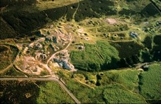
Several small limekilns are present near limestone outcrops, but more obtrusive are the remains of 19th-century lead, silver and zinc mines, largely of the period between the 1860s and 1890s, particularly on the northern area of the moor and forming part of a more extensive mining landscape which extends northwards towards Minera, including the well-preserved extensive above and below-ground complexes at Park and Pool Park mines and generally more isolated shafts elsewhere, interlinked by a network of trackways and footpaths. Characteristic mining remains include runs of shaft along mineral veins in the sandstone, drainage adits, heaps of mineral waste, processing areas, and the foundations of tramways and engine houses. Other landscape features include two leat systems which drew water from the Aber Sychnant stream, one supplying the Pool Park and Lower Park just to the north, and the other supplying the Minera mines across the valley, several kilometres further north.
The moorland has been managed for grouse shooting intermittently since the 19th century administered from the Wynnstay estate’s Mountain Lodge on the eastern side of the moor. Lines of shooting butts, in the form of scoops in the ground encircled by a horseshoe-shaped bank are to be seen on various parts of the moor. These sometimes occur in small groups but there are a number of much longer lines of butts spaced at intervals of about 50 metres and stretching in some instances for more than a kilometre.
Parts of the moor were mistakingly targeted by enemy incendiary bombs during the Second World War, leaving bomb craters which are still visible in places. Other remains of this period include the mountain-top road between Minera and World’s End that was created along the line of earlier trackways, and a brick and concrete observation post on the eastern side of the moor overlooking Wrexham.
Sources
Bennett 1995; Burnham 1995; CPAT Historic Environment Record; Davies 1929; Denbighshire Countryside Service 2003b; Jones 1999; Jones et al. 2004; Lynch 1969; Richards 1969; Silvester and Hankinson 1995; Wrexham 2003For further information please contact the Clwyd-Powys Archaeological Trust at this address, or link to the Countryside Council for Wales web site at www.ccw.gov.uk.
Privacy and cookies