Cymraeg / English

|
Vale of Llangollen Historic Landscape |

|
Character area map |
|
|
More photographs |
Historic Landscape Characterisation
The Vale of Llangollen:
Vivod
Llangollen Community, Denbighshire
(HLCA 1146)
Irregular fieldscapes and woodland in stream valleys and hillslopes south and west of Llangollen with 19th-century estate, estate farms and cottages.
Historic background
By the 7th or 8th century the area fell within the Welsh kingdom of Powys, and from the late 12th century within the subdivided northern portion of the kingdom, known as Powys Fadog. Following the Edwardian conquest of Wales in the late 13th century the area to the south of the Dee fell within the newly-created marcher lordship of Chirkland. Following the Act of Union in 1536 it formed part of the newly created county of Denbighshire.
Little evidence of early settlement and land use has so far been found within the character area. The western part of the area, together with part of the Craig-dduallt character area, fell within the extent of woodland known as Cwmcathi forest in the 14th century, belonging to the medieval lordship of Chirk. The townships of Vivod and Bache were in existence by at least the 14th century, each comprising a number of gafaelion or family holdings which produced wheat and oats amongst other produce. Part of the eastern part of the area appears to have formed part of the medieval monastic grange of Tirabad belonging to the Cistercian monastery of Valle Crucis. Some indication of the nature of earlier settlement and land-use of perhaps the medieval period is suggested by place-name evidence. The element maid (‘whey’) in the name Hafod-y-maidd suggests an origin as a seasonally-occupied upland farm associated with dairying. Unusually, only one farm — Ty’n-y-pistyll — includes the common element tyddyn representing upland farms of free tenants. Several isolated houses, such as Ty-cerrig, Ty-uchaf and Ty-isaf have the common element ty which often refers to a cottage. In the later 18th and 19th centuries much of the area came to form part of the Vivod estate which remains to the present day.
Key historic landscape characteristics
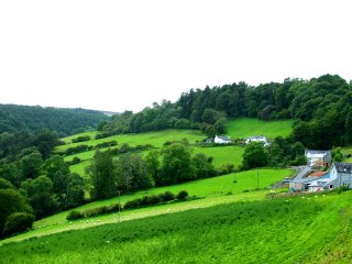
The area occupies the steeply sloping hills and stream valleys of the Eirianallt, Nant y Bache and Cyflymen to the south and west of Llangollen, mostly between a height of 100–400m above sea level. A patchwork of predominantly small irregular fields on much of the lower lying ground representing gradual woodland clearance and enclosure from at least medieval times. Areas of remnant native broadleaved woodland and scrub vegetation survive on some of the steeper slopes and in stream valleys. Patterns of more regular, straight-sided fields on some of the higher ground within and around the margins of the area probably represent enclosure of fringe areas of upland grazing from about the 17th and 18th centuries onwards. A number of areas of estate conifer plantations were created in the 19th and 20th centuries. Many of the field boundaries on the lower, more anciently enclosed land are marked by multiple-species hedges some mature trees, supplemented in many areas by distinctive forged-iron estate fencing, giving way to single-species hedges, some now overgrown, together with post and wire fences and drystone walls in more marginal upland parts of the area. Modern land use is predominantly for sheep grazing though lynchet formation is widespread and confirms that arable farming was more widely practised in the past.Settlement is largely represented by dispersed, medium-sized farms, many still belonging to the Vivod estate. Typical of these is Ty Cerrig, a stone-built farmhouse of the mid 18th century, built up and down the slope and with an attached range on the downhill side. The focus of the Vivod estate is represented by the Victorian house at Plas-yn-Vivod of the 1850s and 60s, built on the site of an 18th-century and probably earlier house, together with its associated gardens and former picturesque walks, lodge, estate workers’ cottages and the extensive contemporary stone-built dairy complex and stable and cartshed at the adjacent estate farm of Bryn-Newydd.
Water-power was probably harnessed for grinding corn within the character area from medieval times, being represented by the later Bache and Pengwern mill complexes on the Cyflymen stream just to the south of Llangollen, the Eirianallt stream being harnessed for electrical power by the Vivod estate.
Small stone quarries sprang up generally around the upland fringes of the area probably from the later medieval period onwards, principally for house and wall building.
Sources
Cadw Listed Building Lists; CPAT Historic Environment Record; Frost 1995; Hubbard 1986; Williams 1990; Jones 1932For further information please contact the Clwyd-Powys Archaeological Trust at this address, or link to the Countryside Council for Wales web site at www.ccw.gov.uk.
Privacy and cookies