Cymraeg / English

|
Vale of Llangollen Historic Landscape |

|
Character area map |
|
|
More photographs |
Historic Landscape Characterisation
The Vale of Llangollen:
Craig-dduallt
Llangollen Community, Denbighshire
(HLCA 1147)
19th-century enclosed upland and woodland bordering southern side of the Vale of Llangollen with evidence of early prehistoric activity.
Historic background
Early activity is indicated by a single flint arrowhead found near Blaenau Uchaf and two isolated Bronze Age burial mounds on land between 390–430 above sea level in the western part of the area near Ffynnon-las and Blaen Nant, which might indicate hunting and clearance for grazing domestic animals in the early prehistoric period. The western part of the area, together with part of the Vivod character area, fell within the extent of woodland known as Cwmcathi Forest in the 14th century, belonging to the medieval lordship of Chirk. Small-scale lead and barytes mining was carried out in the early 20th century at a mine site on the northern margins of the area, near Ty’n y Celyn.
Key historic landscape characteristics
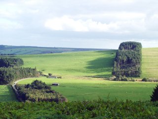
Steeply-sloping and more gently sloping hilltop of the uplands bordering the southern side of the Vale of Llangollen at a height of between about 200–450m above sea level, with improved and enclosed upland pasture, with large and small straight-sided pasture fields representing 19th-century enclosure of hill land. Field boundaries are mostly single-species hawthorn hedges, some now overgrown, and post and wire fences. There are occasional drystone walls and stone-revetted field banks, probably of 19th-century date, some of which are in a dilapidated condition. Scattered large glacial erratic boulders on field margins. Blocks of mixed woodland and 20th-century conifer plantation and strips on some of the steeper slopes or higher ground. Small discrete waterlogged boggy areas. Only a small number of farmhouses and cottages fall within the area, which are largely of 19th-century origin. A number of small stone quarries of probably post-medieval date, for building and wall construction, are scattered throughout the area.
Sources
Archer 1959; CPAT Historic Environment Record; Davies 1929; Pratt 1990; RCAHMW 1914For further information please contact the Clwyd-Powys Archaeological Trust at this address, or link to the Countryside Council for Wales web site at www.ccw.gov.uk.
Privacy and cookies