Cymraeg / English

|
Vale of Llangollen Historic Landscape |

|
Character area map |
|
|
More photographs |
Historic Landscape Characterisation
The Vale of Llangollen:
Pant-y-groes
Llantysilio Community, Denbighshire
(HLCA 1151)
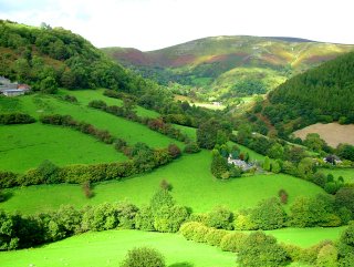
Anciently enclosed farmland and scattered farms in the valley of the Eglwyseg river, below the Horseshoe Pass, including the historically important remains of Eliseg’s Pillar and Valle Crucis abbey and significant remains of the slate industry.
Historic background
Scant evidence of prehistoric activity is suggested by the chance find of a late Bronze Age socketed axe from near Pentredwr dating to about the 10th-century BC and Roman activity by the discovery of a small hoard of 2nd-century AD coins from near Maesyrychen-bach. From about the 7th century the area fell within the kingdom of Powys. Eliseg’s Pillar, the lower portion of a stone cross, was set up on a mound at a focal point in the valley in the first half of the 9th century by Cyngen, king of Powys, in honour of his great-grandfather, Eliseg, who had reunited the kingdom by taking land taken by the English. The location of this important and unusual monument, sited either on Eliseg’s burial mound or upon an earlier prehistoric monument, suggests the presence of a royal estate here in the valley. The recording of the inscription by Edward Llwyd in the late 17th century has been important to the our understanding of the early history of the kingdom of Powys. From 1191 the commote of Iâl fell within the subdivided northern portion of the kingdom known as Powys Fadog. The lower portion of the Eglwyseg valley was granted by Madog ap Gruffudd Maelor for the foundation of the Cisterican monastery known in Welsh as Llanegwestl in Latin as Valle Crucis in Latin, the latter at least being named after the earlier cross, Eliseg’s Pillar. The foundation of the monastery involved the displacement of a number of inhabitants of Llanegwestl and their removal to townships in the vicinity of Wrexham and will almost certainly have involved the reorganisation of the landscape in its immediate vicinity. The lands granted to the monastery continued to be administered as a separate monastic manor up until the Dissolution of the abbey in 1537, and included a farm, a corn mill on the river Dee at Pentrefelin and a fulling mill at Pandy, to the north of the abbey. Following the Edwardian conquest in the later 13th-century the northern portion of the area formed part of the newly-created marcher lordship of Bromfield and Yale until the Act of Union in 1536, following which the whole area formed part of the newly created county of Denbighshire. Antiquarian interest in the antiquities of the Eglwyseg valley commenced in the 16th and 17th centuries. Before the opening of the Horseshoe Pass (Bwlch Oernant) turnpike road in 1811 the main road between Llangollen and Ruthin was by way of the earlier turnpike road Eglwyseg valley through Pentredwr, described by the antiquary Richard Fenton in 1808 as ‘prodigiously steep, and continues so for a mile and a half’ and it was from the second half of the 18th century that the picturesque qualities of the Pillar of Eliseg and Valle Crucis began to ensure that they became important sites of interest to early tourists in north Wales. Tourism and pastoral farming form the mainstay of the local economy at the present day.
Key historic landscape characteristics
The character area falls within and encompasses the enclosed land within the middle and lower portions of the valley of the river Eglwyseg and its tributaries, between a height of 90–390 metres above sea level, a deep and narrow valley of glacial origin which joins the Dee valley just to the west of Llangollen. The underlying solid geology is composed of Silurian shales. The character area is dominated by fieldscapes, with some areas of scrub, broadleaved woodland and conifer plantation. The upper portion of the valley is predominantly composed of small irregular fields and the lower portion of the valley is predominantly large irregular fields, the latter probably reflecting landscape reorganisation carried out at the time when Valle Crucis was founded. Field boundaries are mostly multi-species hedges, in many cases probably of ancient origin. Modern land use is mostly as improved pasture, though the widespread occurrence of field lynchets indicates that ploughing for cereals was much more widespread at periods during the past.Present-day settlement is largely representative of a traditional farming community with a short period of prosperity from the slate quarrying industry. In terms of settlement farming is characterised by a relatively small number of farmsteads, often sited on the hill margins. An early phase of timber building is evident at Bwlch-issa where there is a rare survival of a probably 17th-century timber-framed farmhouse and associated outbuilding in a complex of later stone buildings including a cowhouse and barn with vent holes. The whitewashed rubble stone farmhouse at Pen-y-clawdd is characteristic of a somewhat later horizon of stone-built farm complexes. The late 18th or early 19th-century farmbuildings at Maes-y-llyn are particularly interesting because they are partly built of stonework taken from the ruins of Valle Crucis Abbey following the Dissolution. The small nucleated settlement at Pentredwr lies on the former course of the turnpike road between Llangollen and Ruthin and largely developed at the time of the when the slate quarrying industry was at its height in the 19th century. It formerly possessed a school, shop, post office, public houses, and two 19th-century chapels, and includes a number of former mine workers’ cottages. A row of cottages at Abbey Terrace probably also owes its origin to the slate industry and the haulage of slate to the slate mill at Pentrefelin.
Former fulling mills are indicated by place-name evidence, including Pandy, just to the north of Abbey Farm, fed by a leat taken off the Eglwyseg a little distance to the north, appears to have originated as a monastic mill during the medieval period. Its later history is poorly documented but evidently continued up to the 1870s or beyond, tenters (drying racks) being shown on the field now occupied by the caravan park next to the abbey on Ordnance Survey maps published in 1875. A further poorly-documented fulling mill is indicated by the place-name Hęn-bandy on the Eglwyseg just over a kilometre further north.
Several small early hillside slate workings probably of the 17th century are survive within woodland plantations at Oernant old quarry below the Horseshoe Pass and the small workings at Foel to the east of Pentredwr. The Craig Wynnstay quarry to the north of Pentredwr opened in 1886 and closed in the early 1900s. The opening of the larger Moel-y-faen, Clogau and Oernant quarries on the hillsides to the west of the character area during the earlier 19th century led to great pressures on the local road network and as a consequence a horse-drawn tramway system was constructed through the character area in the 1850s, which by means of an incline passing below a road bridge at Maesyrychen, a stone-revetted revetted embankment alongside the main Ruthin road, and a tramway viaduct across the Eglwyseg river carried material to the slate mill on the canal wharf at Pentrefelin.
A toll-gate is shown on early editions of the Ordnance Survey, just to the north of the Britannia Inn. Probably contemporary with the improvements to the turnpike road in the early 19th century is the Gothic-style well-house on the roadside facing the lane to Valle Crucis abbey.
Sources
Abse 2000; Bingley 1814; Borrow 1862; Burnham 1995; Butler 1976; Cadw Listed Clwyd Fine Arts Trust (not dated); Building Lists; CPAT Historic Environment Record; Davies 1929; Davies 1977; Denbighshire Countryside Service 2003b; Edwards 1985; Emery 2000; Evans 1995; Fisher 1917; Hill and Worthington 2003; Hubbard 1986; Jack 1981; Jenkins 1969; Jones 1932; Jones 1999; Knight 1995; Lewis 1833; Lhwyd 1909-11; Knowles and Hadcock 1963; Lord 2000; Martin 1999; Moore 2000; Nash-Williams 1950; Pennant 1773; Pratt 1987; Pratt 1995; Pratt 1997; Price 1952; Radford 1971; Radford 1974; RCAM 1914; Richards 1991; Roberts 2001; Robinson 1998; Shanes 1979; Sherratt 2000; Smith 1988; Stephens 1986; Williams 1974; Williams 1990; Williams 2001For further information please contact the Clwyd-Powys Archaeological Trust at this address, or link to the Countryside Council for Wales web site at www.ccw.gov.uk.
Privacy and cookies