Cymraeg / English

|
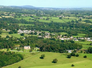
Vale of Llangollen Historic Landscape |

|
Character area map |
|
|
More photographs |
Historic Landscape Characterisation
The Vale of Llangollen:
Garth
Llangollen Community, Denbighshire, and Llangollen Rural Community, Wrexham
(HLCA 1155)
Sloping ground on south-eastern edge of Ruabon Mountain with rural landscape of medieval and late medieval origin partly superimposed by 19th and 20th-century industrial remains and dispersed settlement at Garth.
Historic background
Early settlement and land use in the area is suggested by antiquarian records of a number of possible earlier prehistoric burial mounds (now unlocated) and the later prehistoric Pen-y-gaer hillfort on a hill spur to the east of Garth. From the early medieval period the area fell within the Welsh kingdom of Powys and from the late 12th century in the commote of Maelor Gymraeg within the subdivided northern portion of the kingdom known as Powys Fadog. Following the Edwardian conquest in the late 13th century the area formed part of the marcher lordship of Chirk and in the 14th century it may have formed part of the forest of Isclawdd. Native Welsh farming communities were in existence at Trevor Issa by the late 14th century. Following the Act of Union in 1536 the area became part of the newly created county of Denbighshire. Part of the area was transferred to Wrexham County Borough Council in 1997.
Key historic landscape characteristics
The area lies on the south-eastern edge of Ruabon Mountain, dropping fairly regularly in height from the unenclosed land at about 360 metres above sea level down to the edge of the Dee valley above Trevor, at about 130 metres. The underlying geology is composed of sandstone overlain by Coal Measures including marls to the east. Topographically, the area is bounded to the east by the steep-sided valley of the Tref-y-nant stream which includes sinuous broadleaved woodland, possibly representing residual ancient woodland.The area lies on the margins of the margins of the industrialised area of Acrefair and Cefn Mawr and bears some traces of earlier industry and associated workers’ housing, superimposed upon an earlier agricultural landscape characterized by scattered farmsteads and predominantly small irregular fields probably of medieval and early post-medieval origin, mostly in use as improved pasture. Towards the upland margin are a number of smaller areas of large and small straight-sided fields deriving from post-medieval upland enclosure together with areas of probably 19th-century estate conifer plantation at Black Wood and Trevor Wood.
Industrial remains of the earlier 19th century within the area include a number of isolated limekilns mostly around the upland margin to the west, together with several small limestone quarries and a small isolated former coal mine. From the middle of the 19th century industry was focused on the former complex close to the railway at Trevor, known as the Garth Brickworks, where marls, silica deposits and stone were quarried from opencast workings and a drift mine at various periods, used for the manufacture of bricks, fire-bricks and other materials for the steel industry until the late 1970s. The workings were once linked by aerial ropeway to an additional clay pit further uphill. Many of the former buildings and structures have been demolished and the site is about to be redeveloped for a housing development within which a flooded former stone quarry will be retained as a wildlife pond.
The linear settlement running downhill from Garth to Garth Trefor and Trefor-isaf originated as a settlement for quarrymen and industrial workers in the 19th and earlier 20th century, and included at various times a school, three nonconformist chapels and several public houses.
The small Gronwen, Gwernydd and Sugn-y-pwll reservoirs were constructed on the hillside above Trevor in about the mid 19th century to supply the industrial centres at Cefn, Acrefair and Rhosymedre.
The castellated, stone-built folly known as Trevor Tower was constructed on part of the Trevor Estate in the 1820s. It is sited on the south-eastern edge of Tower Wood on the hillside overlooking the Vale of Llangollen.
Sources
Baughan 1980; Bruce 1921; Cadw Listed Building List; Connolly 2003; CPAT Historic Environment Record; Davies 1929; Edwards 1987; Forde Johnston 1976; Hubbard 1986; Jones 1932; Pratt 1990; RCAM 1914; Wrexham 2003For further information please contact the Clwyd-Powys Archaeological Trust at this address, or link to the Countryside Council for Wales web site at www.ccw.gov.uk.
Privacy and cookies