Cymraeg / English

|
Maelor Saesneg
Historic Landscape |

|
Character area map |
Historic Landscape Characterisation
Maelor Saesneg:
Ywern
Bangor Is-y-coed and Willington Worthenbury communities, Wrexham County Borough
(HLCA 1114)
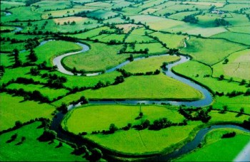 Floodplain with scattered and isolated farms, land traditionally used as meadow, with drainage dykes and ditches in some areas, and with some ridge and furrow possibly indicating areas of open field cultivation during the medieval and early post-medieval periods.
Historic background
The area formed part of the medieval ecclesiastical parishes of Bangor Is-y-coed and Worthenbury, but being predominantly agricultural there is little historical information relating to it.
Key historic landscape characteristics
Distinctive landscape represented by the floodplain of the River Dee at its confluence with the Wych Brook and the Worthenbury Brook, generally fairly flat and below 15 metres above Ordnance Datum, parts of which are subject to seasonal flooding. Archaeological and sedimentary evidence suggests that the course of the river has been relatively stable since later prehistoric or Roman times, with many of the meander cut-offs being infilled during the medieval period. The area to the north of Bangor Is-y-coed is crossed by a flood alleviation bank.The only settlement in the area comprises a small number of isolated farms which probably originated in the post-medieval period. Present-day land use is predominantly pasture, though there are some areas of relict field systems represented by ridge and furrow which appear to represent areas of open field cultivation during the medieval and early post-medieval periods, possibly on a periodic rather than continuous basis. Modern boundaries are generally either formed of thin hedges or post-and-wire fences. Land improvement and water management schemes of post-medieval date are represented by drainage ditches and dykes, area of which have the appearance of water meadows. The modern field pattern is predominantly of large irregular fields with some discrete areas of strip fields which are possibly of medieval origin, associated with ridge and furrow.
Communications are generally limited to the lanes and footpaths giving access to isolated farmsteads and parts of the river bank. The western part of the area was once crossed by the course of the Wrexham and Ellesmere Railway, constructed in the 1890s and closed in the 1960s, following which the viaduct across the river to the north of Bangor Is-y-coed was demolished.
Sources
Baughan 1991Gurnell et al.
Pratt 1998
Pratt 1999
Sylvester 1969
Williams 1997
Regional Sites and Monuments Record
For further information please contact the Clwyd-Powys Archaeological Trust at this address, or link to the Countryside Council for Wales' web site at www.ccw.gov.uk.
Privacy and cookies