Cymraeg / English

|
Maelor Saesneg Historic Landscape |

|
Character area map |
Historic Landscape Characterisation
Maelor Saesneg:
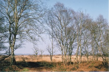
Fenn's Moss
Bronington and Maelor South communities, Wrexham County Borough
(HLCA 1129)
 Raised mire with evidence of exploitation from prehistoric and medieval times onwards, and with pollen evidence for the history of vegetation and land-use in the region since the last glaciation.
Historic background
The area includes Fenn's Moss and Cadney Moss, an extensive peaty area, generally between 80-90 metres above Ordnance Datum, continuous with Whixall and Wem mosses on the English side of the border, divided by the Border Drain, which together form one of the largest and most southerly lowland raised mires in Britain. The mosses have developed since the last glaciation on sites with impeded drainage caused by the deposition of glacial till as the ice retreated about 12,000 years ago. It is probable that the mosses were exploited from prehistoric times onwards, but although there is little certain evidence from the Welsh side of the border a Middle Bronze Age axe of a type known as a palstave was found embedded in a pine stump in Whixall Moss. There are few surviving historical records relating to the Welsh areas of the mosses before the early 18th century, though there is evidence from the Whixall manorial records which show that a well-developed system of turbary (common rights to cut peat or turves) was already in existence by the 1570s and which may have evolved from earlier times, and towards the end of the 16th century it is evident that peat cutting and the digging of drainage ditches were taking place hand in hand in certain areas. Powers to enclose parts of the moss were being granted from the early 18th century, common rights being finally extinguished in the 1770s as part of the enclosure of the parish of Hanmer, about when about half the ownership rights were awarded to the Hanmer estate and most of the rest to numerous single individuals, which led to the creation of over a hundred narrow turbary allotments, the rights also being granted for getting sand to repair the designated roads leading from the moss, the enclosures serving to order and define the landscape, enclosure also being associated with extensive drainage schemes, and formalised the network of footpaths, tracks and roads. Enclosure eventually gave rise to the to a commercial peat-cutting industry, beginning in the 1850s under leases issued by the Hanmer Estate, which continued with increasing intensity until production was finally brought to an end in the last decade of the 20th century following the purchase of the mosses by the Nature Conservancy Council. The mosses were crossed by the Ellesmere Branch of the Shropshire Union Canal, completed in 1804, and by the Ellesmere and Whitchurch Railway, which began operations in 1863. Large areas of Fenn's Moss were commandeered by the army in the First World Wars for use as rifle ranges and during the Second World War as a gunnery and bombing range and as a decoy site designed to protect industrial centres and civilian settlements in the Wrexham, Deeside and Liverpool area.Key historic landscape characteristics
In terms of modern land use the mosses combine some areas of uncut peats, former peat cuttings, alder carr and regenerated native scrub, together with some areas of pasture created by the drainage of certain areas. Areas of conifer plantation, such as Fenn's Wood were planted in the 1960s. Peats in the Welsh area of mosses are over 8 metres in depth in the uncut area of Oafs Orchard, though in cut areas there is an average of only 3 metres and in a few areas the peat has been entirely removed, down to the surface of the underlying subsoil. A substantial area of the moss forms the Fenn's Whixall and Bettisfield Mosses National Nature Reserve, managed by the Countryside Council for Wales and English Nature.Although the primary significance of the mosses today is as a nature conservation area, they also preserve significant evidence of the history of exploitation during the course of the last four or five hundred years. Older peat cutting by linear hand cuts are visible in certain areas, which are clearly distinguishable from firstly the areas commercially hand-cut by the 'Whixall Bible' method (with reference to the shape of peat blocks), and by more recent mechanised cuttings methods. Also surviving here and there are traces of the former tramroads and narrow gauge railways that were used for transporting peat, together with the former peat works known as the as Fenn's Old Works, thought to be the last such works in mainland Britain. Traces are also visible of the First World War shooting butts and targets of the Second World War bombing range. The railway across the mosses ceased operation in the 1960s, but its course is still clearly marked by a pair of drainage ditches and by the course of the track which was bedded on heather, peat, bundles of faggots, and a thick bed of sand dug from local sand pits.
Pollens preserved in the peat deposits in the mosses have been studies since the 1930s but still represent an important source of environmental evidence for the history of climate change, vegetation, land use and human activity in the region since the end of the last glaciation.
Sources
Baughan 1991Berry et al. 1996
Berry & Gale 1996a, 1996b
Brassil et al. 1991
Caseldine 1990
Chambers et al. 1996
Daniels 1996
Hardy 1938
Jenkins 1991
Musson 1994
Pratt & Grant 1996
Turner 1964
Regional Sites and Monuments Record
For further information please contact the Clwyd-Powys Archaeological Trust at this address, or link to the Countryside Council for Wales' web site at www.ccw.gov.uk.
Privacy and cookies