|

Cymraeg / English
|

|
Historic Landscape Characterisation
The Middle Wye Valley
The following description, taken from the Historic Landscapes Register, identifies the essential historic landscape themes in the historic character area.
|
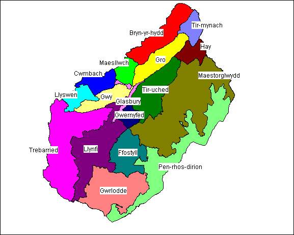
Character areas defined in the Middle Wye Valley Historic Landscape
|
This distinctive Powys landscape lies to the south west of Hay-on-Wye in the shadow of the Black Mountains, and runs from Hay Bluff at its north end to Mynydd Troed in the south. The landscape identified includes the floodplain and steeply sloped northern edge of the Wye valley, and the deeply incised plateau beneath the northern scarp of the Black Mountains.
This particular region of the Wye valley is in many ways similar to the Usk valley further to the south west, around Brecon, typified by small hedged fields enclosing the rich agricultural land on the valley floor between about 80 to 100m above OD. To the south east the land rises steeply onto the Black Mountains, which reach up to 700m above OD, with evidence of agrarian encroachment along the lower slopes, rising onto the open moorland beyond. The area has a rich and varied history with important cultural associations.
Along the southern side of the valley, on the edges of the upland, lie a series of important Neolithic funerary monuments of a type known, because of their distinctive form and plan, as Severn-Cotswold tombs. These tombs were in recurrent use as communal repositories for the remains of the dead during the later half of the fourth millennium BC. There are impressive tombs surviving at Penywrlodd (Llanigon), Little Lodge, Pipton, Fostyll and Penywrlodd (Talgarth). Among the other impressive prehistoric monuments in the area of the is the Pen-y-Beacon Bronze Age stone circle on the edge of the Black Mountains.
Although much of the area owes its appearance to Anglo-Norman influences, there is significant evidence for native Welsh settlement. Glasbury is thought to have originally been a clas foundation (the administrative centre of a monastic unit of settlement in medieval times), and it is also recorded as being the site of the Battle of Clasbirig in 1056 between the Saxons and the Welsh. Llyswen is reputedly focused on another clas church, founded during the 6th century, and there is documentary evidence for a religious site being given to the See of Llandaff in about AD 650.
The Anglo-Norman settlement is most clearly seen at Hay-on-Wye, which still retains its medieval street plan, with remnants of the castle and town defences. Today, the town is best known for its book shops and the annual festival of literature. Across the Wye from Hay lies the site of the Roman fort alongside the river, and beyond it, Clyro, made famous by the diary of the Reverend Francis Kilvert, who lived in the village in the 1870s. Although many of the places described by Kilvert are currently outside the area described here, the lifelike account he has left of the places and people he knew, has caused the region centred upon Clyro to become known as Kilvert Country, and to become a place of literary pilgrimage. Other important medieval settlements include Talgarth and Bronllys, both of which had extensive open arable field systems surviving up to the middle of the 19th century; that of Bronllys having been only enclosed in 1863. Many of the small villages are thought to have had early medieval origins and some, such as Llanfilo, display important earthwork remains relating to their former medieval extents.
Trefecca is famous for Trevecca College founded in the mid-18th century by Howell Harris, who was well-known for founding early Welsh Methodist societies, assembling a community of about 100 followers at his home, Trevecka Fach, in 1752. The community was influential in printing religious books and also for agricultural improvements.
Along the northern slopes of the Black Mountains lie several commons, such as Tregoyd Common and Common Bychan, which preserve their post-medieval field systems. The landscape here contrasts strongly with the moors to the south-east and the hedged landscape of the valley floor.
 The Natural Landscape The Natural Landscape
The Administrative Landscape
Settlement Landscapes
Agricultural Landscapes
Architectural Landscapes
Transport and Communications
Industrial Landscapes
Defended Landscapes
Religious Landscapes
Ornamental and Picturesque Landscapes
Character areas
|
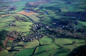
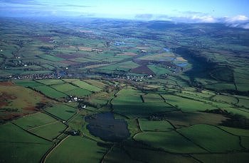
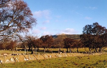
1082 Bryn-yr-hydd character area.
Small medieval nucleated church and castle settlements on valley edge, and medieval and later scattered farmsteads on lower-lying hill land in landscape of small irregular fields, representing gradual encroachment on upland commons.
Photo: CPAT 00c0079.
(back to map)
|
Click here for further information about this Historic Landscape Character area
Click here for character area map
|
|
|
|
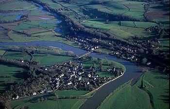
1083 Maesllwch
character area.
Large 19th-century landscape park forming picturesque setting to the Victorian mock Tudor castle occupying area of Glasbury's medieval open fields enclosed in the late 18th century, with remnant areas of ancient semi-natural woodland.
Photo: CPAT 00c0117.
(back to map)
|
Click here for further information about this Historic Landscape Character area
Click here for character area map
|
|
|
|
1084 Cwmbach
character area.
Medieval and later dispersed farmsteads on lower-lying hills, in landscape of medium-sized hedged fields and hollow-ways, with remnant strips of ancient semi-natural woodland on steeper slopes.
Photo: CPAT 00c0124.
(back to map)
|
Click here for further information about this Historic Landscape Character area
Click here for character area map
|
|
|
|
1085 Trebarried
character area.
Nucleated medieval church settlement of Llanfilo and scattered medieval and later farmsteads on undulating lower hill land on west of the Llynfi, a number of the farms originating in smaller medieval manors and subtenancies held by either English or Welsh families.
Photo: CPAT 00c0141.
(back to map)
|
Click here for further information about this Historic Landscape Character area
Click here for character area map
|
|
|
|
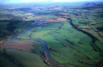
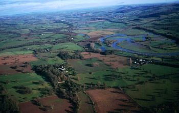
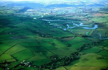
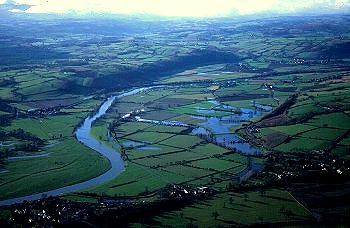
1086 Gro character area.
Floodplain of the Wye between Glasbury and Hay, with oxbow lakes and river meanders and large rectangular fields representing late enclosure of former low-lying common meadow.
Photo: CPAT 00c0099.
(back to map)
|
Click here for further information about this Historic Landscape Character area
Click here for character area map
|
|
|
|
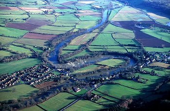
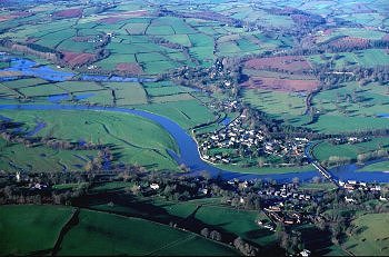
1087 Llyswen character area.
Nucleated medieval church settlement and manors and extensive former open field cultivation on well-drained lower-lying ground spanning the Wye, with later building and structures resulting development of road and railway transport systems in the 18th and 19th centuries.
Photo: CPAT 00c0133.
(back to map)
|
Click here for further information about this Historic Landscape Character area
Click here for character area map
|
|
|
|
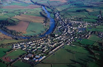
1088 Hay character area.
Medieval castle borough, market town and associated open fields, emerging as important commercial and service centre in 17th and 18th centuries and cultural and tourist centre in the modern period.
Photo: CPAT 00c0085.
(back to map)
|
Click here for further information about this Historic Landscape Character area
Click here for character area map
|
|
|
|
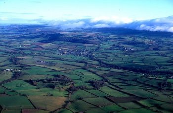
1089 Tir-uched character area.
Medieval and later dispersed farmsteads on lower-lying land bordering the south bank of the Wye between Hay and Glasbury, some deriving from English-held manors.
Photo: CPAT 00c0105.
(back to map)
|
Click here for further information about this Historic Landscape Character area
Click here for character area map
|
|
|
|
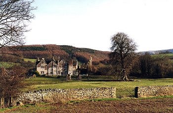
1090 Gwernyfed character area.
Low-lying and gently-sloping landscape with former medieval deer park and hunting lodge, remains of formal Renaissance gardens and manor house, and 19th-century landscape park and country house.
Photo: CPAT 1042-08A.
(back to map)
|
Click here for further information about this Historic Landscape Character area
Click here for character area map
|
|
|
|
1091 Llynfi
character area.
Nucleated settlements and large dispersed farms deriving from medieval English-held manors associated with extensive medieval open fields along the fertile Llynfi valley corridor.
Photo: CPAT 00c0166.
(back to map)
|
Click here for further information about this Historic Landscape Character area
Click here for character area map
|
|
|
|
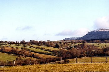
1092
Maestorglwydd character area.
Foothills below the northern escarpment of the Black Mountains, deeply incised by stream valleys with clustered farmhouses, some of late medieval longhouse origin, in landscape of small irregularly-shaped fields and small hilltop commons.
Photo: CPAT 00c0101.
(back to map)
|
Click here for further information about this Historic Landscape Character area
Click here for character area map
|
|
|
|
1093
Ffostyll character area.
Small, isolated church settlement at Llanelieu surrounded by lower hill land at the foot of the Black Mountains with dispersed farmsteads in a landscape of wooded slopes and large polygonal fields perhaps first enclosed early post-medieval period.
Photo: CPAT 1040-06.
(back to map)
|
Click here for further information about this Historic Landscape Character area
Click here for character area map
|
|
|
|
1094
Gwrlodde character area.
Dispersed farmsteads and small orderly fields resulting from the systematic woodland clearance and enclosure on the sloping foothills of the Black Mountains south of Talgarth during the medieval period.
Photo: CPAT 1038-17.
(back to map)
|
Click here for further information about this Historic Landscape Character area
Click here for character area map
|
|
|
|
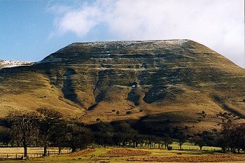
1095
Pen-rhos-dirion character area.
Unenclosed upland common on the northern escarpment of the Black Mountains with prehistoric burial and ritual monuments, traces of marginal agriculture, quarrying, and abandoned post-medieval encroachments.
Photo: CPAT 1040-01.
(back to map)
|
Click here for further information about this Historic Landscape Character area
Click here for character area map
|
|
|
|
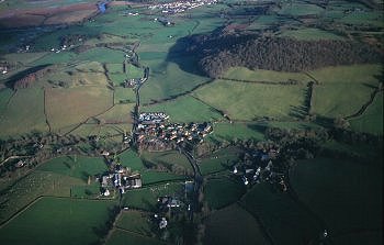
1096
Tir-mynach character area.
Orderly lowland farming landscape laid out on hummocky glacial moraine, with a field pattern possibly reflecting the presence of a Roman fort and medieval monastic grange.
Photo: CPAT 00c0080.
(back to map)
|
Click here for further information about this Historic Landscape Character area
Click here for character area map
|
|
|
|
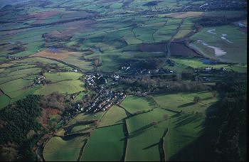
1097
Glasbury character area.
Post-medieval linear settlements along communications corridor, superimposed upon medieval nucleated settlement at important early river crossing on the Wye.
Photo: CPAT 00c0119.
(back to map)
|
Click here for further information about this Historic Landscape Character area
Click here for character area map
|
|
|
|
1098
Gwy character area.
Floodplain of the Wye with oxbow lakes and river meanders and field boundaries representing late enclosure of former low-lying common meadows between Glasbury and Hay.
Photo: CPAT 00c0128.
(back to map)
|
Click here for further information about this Historic Landscape Character area
Click here for character area map
|
|
|
|
|
For further information please contact the Clwyd-Powys Archaeological Trust at this address, or link to the Countryside Council for Wales' web site at www.ccw.gov.uk.
Privacy and cookies
|
