Cymraeg / English

|
Bro Trefldwyn Historic Landscape |

|
Character area map |
Historic Landscape Characterisation
Bro Trefaldwyn:
Pantglas
Churchstoke and Kerry, Powys and Bishop's Castle, Shropshire
(HLCA 1077)
Hill-top, mostly enclosed in late 18th to early 19th century, with ridgeway and series of defensive earthworks of later prehistoric, early medieval, and medieval date.
Historic background
The southern boundary of the character area runs along the Kerry Ridgeway, also known as Yr Hęn Ffordd ('the old road') and The Castle Road (after Bishop's Castle), which here marks the boundary between Wales and England. The ridgeway is thought to have formed part of an important route into central Wales from early times and appears to have also formed one of the drovers' roads by which cattle reared in Wales were taken to markets in the towns of England. The antiquity of the present road is uncertain, though an 18th-century date seems probable. It has been argued that there is a deliberate break in Offa's Dyke near the point where the road and dyke intersect, suggesting that the route is earlier, but the evidence is not conclusive. Other monuments along hill, however, also seem to relate to the presence of the route. The earthwork enclosure at Caer Din, which may be of either later prehistoric or early medieval date, is crossed by a distinct trackway which may indicate an earlier route along the hill, early prehistoric activity in the area being suggested by finds of possible Bronze Age flintwork found near Caer Din. The motte and bailey castle called Bishop's Moat, which is on unusually high ground for this kind of monument, lies at a narrow point along the hill, and possibly controlled access to the land further to the east. Little is known of the history of the motte and bailey castle, described as 'one of the finest and most commodious in the county'. The earthwork is named after the bishops of Hereford who held the area in the middle ages the district known as Bishop's Teirtref. The castle fell at the western end of this territory and would have played a role in the administration of the area.By the 19th century the area fell within the township of Bachaethlon in the parish of Kerry, the townships of Hopton Ucha and Issa, and Mellington in the parish of Churchstoke, the Welsh township of Castlewright in the English parish of Mainstone, and the Welsh township of Aston in the English parish of Lydham, and the township of Broughton in the parish of Bishop's Castle, and the borough and township of Bishop's Castle.
Key historic landscape characteristics
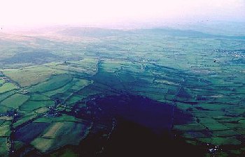
The area forms a relatively level hilltop between a height of between 250-400m above Ordnance Datum broken by a series of narrow steep-sided stream valleys to the north. The solid geology is composed of Silurian shales, generally with relatively well-drained brown podzolic soils. There are areas of ancient replanted woodland on steeper slopes including Gyfenni Wood, and a number of small scattered conifer plantations.The modern settlement pattern consists of widely scattered farms generally below the crest of the hill and a several stone 18th-century roadside cottages along the ridgeway, including the former Dog and Duck Inn, a the small rendered stone farmhouse with low barn at Pen-y-cwm, and a modern farmhouse with 18th to 19th-century brick and stone farm buildings at Hopton Bank.
Present-day land-use is predominantly improved pasture. The landscape is subdivided into large rectangular and polygonal fields with generally low cut hawthorn, single species hedges and extensive use of post and wire fences to subdivide larger enclosures. Some of the roadside hedges along the ridgeway are multi-species, including hazel, oak, ash, holly, blackthorn and birch and appear to be older than some of the field boundaries which butt up against them, many of the field boundaries in the area represent relatively late enclosure of formerly unenclosed upland common. Field-names on the tithe apportionment suggest that before enclosure an area to the east of Moat Farm was used as a racecourse. The area north of Bankshead, at the eastern end of the area, is shown as unenclosed common on the Bishop's Castle Tithe Map of 1843. In the later 19th-century a distinctive landscape of cottages and small allotments was created here from the unenclosed common, represented today by a number of 19th-century brick cottages and green lanes running round the contour of the hill. Areas at the western end of the character area, in the townships of Hopton Uchaf and Issa and in the township of Bachaethlon were enclosed in the first decade of the 19th century.
The Kerry Ridgeway generally keeps to the crest of the hill and forms a relatively narrow metalled track, 2-3m wide running in a much broader zone 10-15m wide, with planted hedges to either side. In places the hedges are expanding onto the grass verges though in other places the roadside hedges are thinning out and disappearing, leaving a pair of low parallel banks.
Published sources
Chitty 1963Earp & Hains 1971
Eyton 1854-60
Fox 1955
Gelling 1983
Jerman 1933-34
Morris 1889
Pryce 1915
Soil Survey 1983
Sothern & Drewett 1991
Spurgeon 1965-66
For further information please contact the Clwyd-Powys Archaeological Trust at this address, or link to the Countryside Council for Wales' web site at www.ccw.gov.uk.
Privacy and cookies