|

Cymraeg / English
|

|
Historic Landscape Characterisation
The Vale of Montgomery
The following description, taken from the Historic Landscapes Register, identifies the essential historic landscape themes in the historic character area.
|
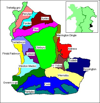
Character areas defined in the Bro Trefaldwyn Historic Landscape
|
The Vale of Montgomery lies across the English-Welsh border, in north eastern Powys and western Shropshire, and occupies a natural basin, some 6km across, formed at the confluence of the Rivers Severn and Camlad. Away from the terraces associated with these rivers, the basin floor is undulating and dotted with small local summits of no more than 160m above OD, while the rim, which defines the limits of this landscape, rises to over 300m above OD on all sides. The rim is delineated by the Kerry Ridgeway on the south, Long Mountain on the north east and the eastern Montgomery Hills to the west.
The area contained within this natural amphitheatre surrounding Montgomery presents ample evidence for the historical struggle for control of territory and communications which has so typified Welsh history. The landscape preserves remnants of fortification, boundaries, settlements and field systems from prehistory to the medieval period, reflecting the ebb and flow of conflicting claims to the land.
Early habitation is evidenced by the Iron Age hillfort of Ffridd Faldwyn, just above and to the west of Montgomery. The Kerry Ridgeway forming the landscape's southern limits has been an important line of communication since prehistoric times.
The efforts to control the native population and communication routes are clearly shown during the Roman period with the existence of two forts, at Forden and Brompton. Forden Gaer survives as an impressive earthwork which is surrounded by crop-marks visible from the air, indicating an associated settlement or vicus. Numerous crop-mark enclosures representing ploughed out, late prehistoric and Romano-British farms have also been found in the area around the fort. Nearby is Rhyd Whyman, the historically important ford across the River Severn.
One of the main features in the landscape is Offa's Dyke which runs roughly north-south marking the western extent of the 8/9th century kingdom of Mercia. The Dyke remains fairly well-preserved at this point and is plainly visible as a linear spine crossing the valley floor, where, for about 3km, it forms the modern boundary between England and Wales. The mainly post-medieval and modern agricultural landscape of the valley floor is also visually distinctive for its mature hedgerow trees.
The influence of the Normans and the rise of the Marcher barons had an important and lasting effect on the borderlands from the 12th century onwards, and numerous motte and bailey castles give ample testament to the imposition of a foreign culture on this landscape. Hen Domen, in particular, has revealed significant evidence about this troubled period following a series of excavations at the site. It would seem likely that it is the Castrum Muntgumeri recorded in the Domesday Book. In 1223, work commenced on the construction of a new masonry castle overlooking the new borough of Montgomery. The town plan remains largely unaltered since it was mapped by Speed in 1610, and stretches of the defences are still visible. The town itself contains some fine examples of Georgian architecture (notably the Town Hall and Square). Montgomery was also the site of a major Civil War battle in 1644. To the east of the town lies Lymore Park which contains a rare example of a duck decoy in one of the lakes, while Chirbury across the border in Shropshire contains the site of a medieval priory.
 The Natural Landscape The Natural Landscape
The Administrative Landscape
Settlement Landscapes
Agricultural Landscapes
Architectural Landscapes
Transport and Communications
Industrial Landscapes
Defended Landscapes
Funerary, Ecclesiastical and Legendary
Landscapes
Ornamental and Picturesque Landscapes
Character areas
|
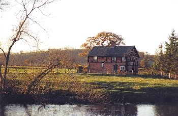
1062 Trehelig-gro character area. Possibly early 17th-century timber-framed cottage with later brick infill on the western banks of the Severn near Dyffryn farm. There was a ferry and a ford across the river at this point until the later 19th century taking traffic by a series of lanes between Berriew and Forden. Photo: CPAT 921.18A
(back to map)
|
Click here for further information about this Historic Landscape Character area
Click here for character area map
|
|
|
|
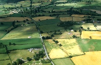
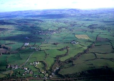
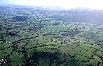
1063 Forden character area looking northwards towards Kingswood in the background and Nantcribba Gaer in the trees to the right, with Offa's Dyke visible to the right of the road and running towards Long Mountain in the background. Much of the area remained as common land until the beginning of the 19th century, when numerous small tenements and cottages were erected. Photo: CPAT 83-C-301.
(back to map)
|
Click here for further information about this Historic Landscape Character area
Click here for character area map
|
|
|
|
1064 Gunley character area, with the Jacobean and late Georgian Gunley Hall in the foreground, set in ornamental parkland to either side of the road which runs down to the banks of the Camlad on the extreme right. The parkland overlies ridge and furrow representing an area of medieval open-field arable in the township of Ackley, emparked in possibly the 17th or 18th century. The road, which now deviates around the house, lies on the course of the Roman road between Roman fort at The Gaer and Wroxeter. Photo: CPAT 92-C-680.
(back to map)
|
Click here for further information about this Historic Landscape Character area
Click here for character area map
|
|
|
|
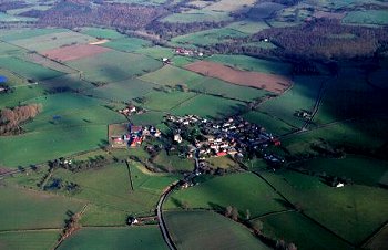
1065 Penylan character area, looking eastwards with Fron in the foreground and Kingswood in the middle distance. Edderton, the isolated farm and hall towards the centre right, is first mentioned in the Domesday Book under the name Edritune, with ploughland and sufficient woodland for fattening 60 pigs. It was one of a number of Mercian settlements in the area, to the west of Offa's Dyke, established in perhaps the 9th or 10th century, which though recovered by the time that the Domesday Book was compiled in 1086, had been laid waste probably due to Welsh guerilla warfare a generation earlier. Photo: CPAT 00-C-029
(back to map)
|
Click here for further information about this Historic Landscape Character area
Click here for character area map
|
|
|
|
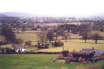
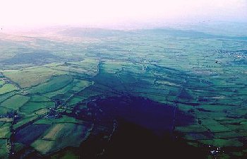
1066 Fflos character area in the foreground, looking southwards towards the modern grain silos of Winsbury and Dudston in the background. Much of the land remained Fflos character area survived as unenclosed pasture until the early 19th century. Photo: CPAT 921.12A
(back to map)
|
Click here for further information about this Historic Landscape Character area
Click here for character area map
|
|
|
|
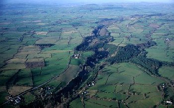
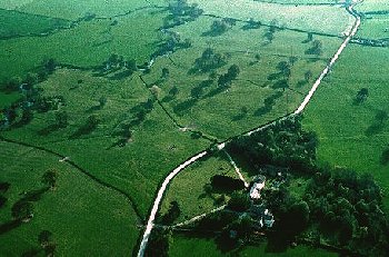
1067 Marrington Dingle character area, looking north, with Calcot Farm in the middle distance and Spy Wood to the right. The steep-sided gorge was formed during the late glacial period as water held in a lake in the upper Camlad escaped northwards into the Rea valley. Water-power from the Camlad was harnessed from the medieval period onwards for a string of corn mills and fulling mills. The steep-sided edges of the gorge were employed by the later prehistoric defensive earthworks at Caerbre and Calcot Farm. Photo: CPAT 00-C-056
(back to map)
|
Click here for further information about this Historic Landscape Character area
Click here for character area map
|
|
|
|
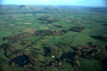
1068 Lymore character area, a landscape park listed in the Historic Gardens Register, looking eastwards, showing the largely artifical pools in the foreground. The Upper Pool, on the right, had been created before 1785, the Lower Pool and the Decoy Pool hidden in trees on the extreme right having been constructed between 1786 and 1828. The parkland overlies an important area of medieval ridge and furrow which probably representing part of the open-fields belonging to the town of Montgomery. Photo: CPAT 00-C-061
(back to map)
|
Click here for further information about this Historic Landscape Character area
Click here for character area map
|
|
|
|
1069 Yr Ystog character area, looking north-westwards across the area of Old Church Stoke, with Stone House in the foreground. Numerous small farms and cottages became established in the area of Old Church Stoke between the 16th and 18th centuries, expanding away from the medieval village core further south. Photo: CPAT 923.19
(back to map)
|
Click here for further information about this Historic Landscape Character area
Click here for character area map
|
|
|
|
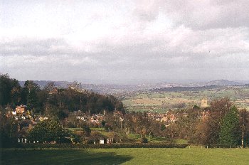
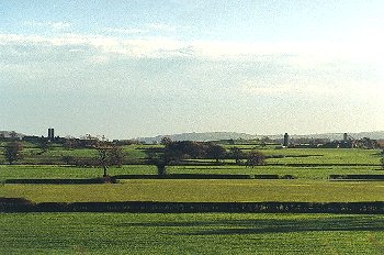
1070 Trefaldwyn character area, with a view of the town of Montgomery from the south. Photo: CPAT 923.10
(back to map)
|
Click here for further information about this Historic Landscape Character area
Click here for character area map
|
|
|
|
1071 Aldress character area, looking eastwards, with the wooded Marrington Dingle in the foreground and Lan Fawr and Corndon Hill in the background. Irregular but orderly arrangement of medium-sized fields, generally set out along the contour and with some fields on the west encroaching onto the lower slopes of Lan Fawr. Photo: CPAT 00-C-032
(back to map)
|
Click here for further information about this Historic Landscape Character area
Click here for character area map
|
|
|
|
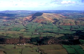
1072 Todleth character area, looking northwards across the upper Camlad valley, with Todleth Hill, Roundton and Corndon Hill visible in succession in the distance. Photo: CPAT 00-C-035
(back to map)
|
Click here for further information about this Historic Landscape Character area
Click here for character area map
|
|
|
|
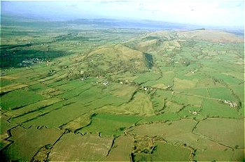
1073 Hyssington character area, from the north, with Woodgate Farm in the foreground and the village of Hyssington with its associated medieval church and motte and bailey castle in the middle distance. The low hill in the foreground is formed of an igneous intrusion of picrite which was quarried in the early Bronze Age for the manufacture of battle-axes and axe-hammers. Photo: CPAT 00-C-037
(back to map)
|
Click here for further information about this Historic Landscape Character area
Click here for character area map
|
|
|
|
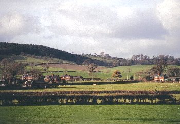
1074 Chirbury character area, showing the village of Chirbury viewed from the west. A defensive burh was founded at Chirbury in 915, during the Danish wars. It subsequently became the principal manor of the Domesday hundred of Witentre and the site of an Augustinian priory. Extensive remains of ridge and furrow representing medieval arable open-field cultivation survive in the fields on all sides of the village. Photo: CPAT 00-C-030
(back to map)
|
Click here for further information about this Historic Landscape Character area
Click here for character area map
|
|
|
|

1075 Gwern-y-go character area, looking eastwards, with Pentrehyling in the foreground and Churchstoke in the background and the line of Offa's Dyke cutting across the landscape from left to right. The Pentrehyling Roman fort was first identified by aerial reconnaissance in the late 1960s in the fields just beyond the farm. The fort has been intensively ploughed for many years and its defences are no longer visible as an earthwork site. Photo: CPAT 00-C-062
(back to map)
|
Click here for further information about this Historic Landscape Character area
Click here for character area map
|
|
|
|
1076 Weston Madoc character area, showing the a distinctive area of county council smallholdings in the area between Pen-y-bryn Hall and Great Weston Farm, established between the two world wars. A number of larger fields in the area were subdivided, to allow for smaller land holdings. Photo: CPAT 923.13
(back to map)
|
Click here for further information about this Historic Landscape Character area
Click here for character area map
|
|
|
|
1077 Pantglas character area looking eastwards, with Upper Castlewright in the foreground and Bishop's Castle in the far distance. The Kerry Ridgeway, known in Welsh as Yr H�n Ffordd, �the ancient road' runs along the crest of the hill and here marks the boundary between Wales and England. The ridgeway is thought to have formed part of an important route into central Wales from early times and appears to have also been one of the drovers' roads by which cattle reared in Wales were taken to markets in the towns of England. Photo: CPAT 00-C-069
(back to map)
|
Click here for further information about this Historic Landscape Character area
Click here for character area map
|
|
|
|

1078 Cwm character area, with the mid 19th-century Pentrenant Hall on the left and looking north-westwards towards Caeliber Isaf. Photo: CPAT 923.24
(back to map)
|
Click here for further information about this Historic Landscape Character area
Click here for character area map
|
|
|
|
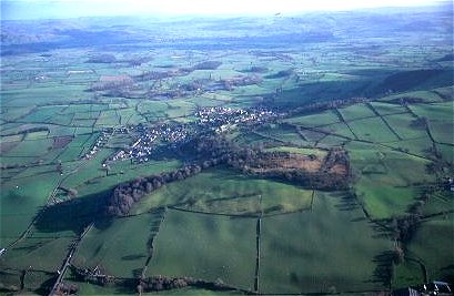
1079 Ffridd Faldwyn character area looking towards the south-east with the later prehistoric hillfort of Ffridd Faldwyn partly encircled by trees in the middle distance and the town of Montgomery beyond. The more rectangular fields on the far side of the hillfort, with mature and multiple-species hedges, probably represent 17th- or 18th-century enclosure of former unenclosed upland grazing belonging to the medieval borough. Photo: CPAT 00-C-017
(back to map)
|
Click here for further information about this Historic Landscape Character area
Click here for character area map
|
|
|
|
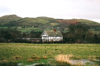
1080 Wernddu character area looking eastwards with the 17th-century timber-framed farmhouse at The Lack in the foreground and Todleth Hill in the background. Lach is one of the early settlements in the area recorded in the Domesday Book compiled in 1086 and at that time probably held by Godbold the priest, one of the learned clerics in the household of Roger of Montgomery. Photo: CPAT 923.14
(back to map)
|
Click here for further information about this Historic Landscape Character area
Click here for character area map
|
|
|
For further information please contact the Clwyd-Powys Archaeological Trust at this address, or link to the Countryside Council for Wales' web site at www.ccw.gov.uk.
Privacy and cookies
|
