Cymraeg / English

|
Tanat Valley Historic Landscape |

|
Character area map |
Historic Landscape Characterisation
The Tanat Valley:
Trebrys, Llanrhaeadr-ym-mochnant and Llansilin, Powys
(HLCA 1004)
Landscape of scattered larger farms of late medieval and early post-medieval origin generally set within their own medium- to large-sized semi-irregular fields.
Historic background
Early activity is represented by the find of a Bronze Age socketed axe near Bronheulog in 1949. The character area falls within the medieval ecclesiastical parishes of Llanrhaeadr-ym-mochnant, Llanarmon and Llansilin, and also falls within the area of the ancient commote of Mochnant Is Rhaeadr, Denbighshire. One of the most prominent archaeological monuments in the character area is the probably 12th- to 13th-century Tomen Cefn Glaniwrch, one of a number of similar sites in Dyffryn Tanat. Like the Tomen Cefn-côch motte about 4.5km to the west, in the adjacent commote of Mochnant Uwch Rhaeadr, Tomen Cefn Glaniwrch is prominently sited, on the edge of the lower hills. There is no evidence of medieval settlement or land-use in the immediate vicinity of either of these two mottes, suggesting that both of them probably had a purely military function.
Key historic landscape characteristics
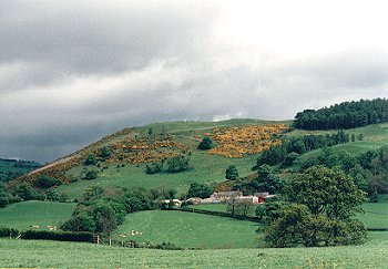
Uneven, broken landscape of low hills, with a general slope downhill from the north-east to the south-west, and ranging in height from between about 130-330m OD. The area is bounded by upland areas on the north, and east, by the Afon Iwrch on the west and the Lleiriog stream on the south-east. On the east is the distinct valley between the hills followed by the Lleiriog, with areas of flatter ground along the banks of the stream.
Settlement is confined to numerous scattered, large and well-established farms of probable late medieval or early post-medieval origin often set within their own fields and generally up to about 0.6km apart. New fields were probably being actively cleared from woodland and waste during the Tudor period. The demand for land at this time is illustrated by the fact that as late as about 1560 Maurice ap Meredith of Lloran-uchaf, a small estate on the eastern side of the character area, was still continuing the earlier custom of dividing his estate between his eight sons.
A majority of the farms have 17th- to 19th-century stone farmhouses and outbuildings with slate roofs, as at Trewern, Trewern-isaf, Cefn-isaf, Caer-fach, Cefnhirfach, Tyn-y-celyn, Lloran-uchaf and Bronheulog, the farmhouses being rendered or partly rendered in the case of the two latter farms, and with weatherboarding employed on outbuildings at Tyn-y-celyn and Cefnhirfach. There are similar traditional buildings at Trebrys and Trefeiliw, (the farmhouse at the latter being rendered), both of which are accompanied by stone-walled gardens and farmyards. Most of the building stone is of locally quarried shale, but a number of buildings, including older outbuildings at Trebrys and parts of some buildings at Lloran-uchaf, for example, are of rounded stones probably resulting from field clearance. A number of early farmhouses have now been completely replaced by modern buildings, as in the case of the modern brick farmhouse at Lloran-ganol and Caemawr. A number of the farmhouses no longer belong to working farms.
Efail-rhyd by contrast is a small nucleated settlement on a road junction along the Llanrhaeadr to Llansilin turnpike road which evidently developed from a corn mill and smithy and represented by a cluster of 18th/19th-century buildings built of quarried stone with some brick dressings, and possibly reused rounded boulders from earlier structures.
The present-day land-use is predominantly pasture though the widespread occurrence of lynchets, especially on the more sloping ground, indicates that ploughing was much more widely practiced in the past. It is evidently this landscape that was described in the following words by George Borrow in about the mid 19th century:
The valley was beautiful and dotted with various farm-houses, and the land appeared to be in as high a state of cultivation as the soil of my own Norfolk, that county so deservedly celebrated for its agriculture. Wild Wales, 1862
Medium- to large-sized, semi-irregular fields, bounded by often thick, mature mixed-species hedges, including hazel, ash, hawthorn, maple, and holly with scattered larger oaks, some of which have been traditionally laid in the past. Different phases of enclosure appear to be indicated by the field pattern in some areas, as for example in the Lloran-ganol and Bronheulog area, where various groups of fields are strung out along the contour.
Some former hedges have disappeared, being marked by slight banks, lynchets or spaced lines of trees. Some earlier boundaries have been replaced by post and wire fences though in other instances a number of smaller fields have now been amalgamated, or run into one. This has particular affected the fields on the areas of flatter ground towards the tops of the hills rather than the more steeply-sloping ground, which have generally remained smaller. Occasional boundaries include glacially rounded boulders, resulting from field clearance. Occasional stone gateposts to field entrances along the public roads and abandoned milkstands at some farm entrances.
Some of the lower-lying areas are poorly drained, and in some instances there is visible evidence of ridging, as in the case of a field next to Pont Maesmochnant. There are also occasional areas of ridge and furrow on higher ground, as for example near Ty-brith.
Small areas of woodland including semi-natural oak woodland and a number of small conifer plantations on steeper ground and rocky outcrops. Scattered taller trees and shrubs elsewhere, along field boundaries and streams.
There is a complex network of lanes, green lanes and footpaths between individual farms. Some of the lanes run in substantial hollow-ways, up to 1-2.5m deep formed by erosion before drainage road metalling were laid, and are therefore evidently of some antiquity. A number of the deeper hollow-ways are partly revetted in stone, as for example near Lloran-ganol, where rounded boulders probably from field clearance have been used. The most major route crossing the area, the public road between Llansilin and Llanrhaeadr, was a turnpike road created in the later 18th century, probably at least in part by the improvement of a pre-existing track, and involving the construction of new stone bridges at Pont Efail-rhyd across the Lleiriog and Pen-bont across the Afon Iwrch.
Sources
Richards 1943-44; 1945-46Spurgeon 1965-66
Wiliam 1986
For further information please contact the Clwyd-Powys Archaeological Trust at this address, or link to the Countryside Council for Wales' web site at www.ccw.gov.uk.
Privacy and cookies