Cymraeg / English

|
Tanat Valley Historic Landscape |

|
Character area map |
Historic Landscape Characterisation
The Tanat Valley:
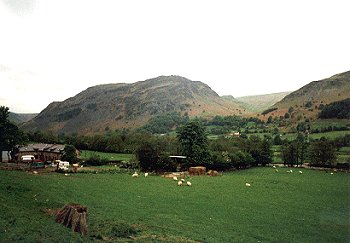
Craig Rhiwarth, Llangynog, Powys
(HLCA 1005)
Prominent craggy mountain with prehistoric hillfort, dominating Llangynog
Historic background
The mountain falls within the medieval ecclesiastical parish of Llangynog, and fell within the ancient commote of Mochnant Uwch Rhaeadr, Montgomeryshire.
The hill is crowned by the large prehistoric hillfort also known by the name of Craig Rhiwarth. It is one of two major hillforts within Dyffryn Tanat and amongst the highest of such forts in Wales. The hillfort is defended by a single stone rampart and entrance on the northern side of the hill enclosing an area of about 24ha, the remaining three sides being so precipitous that artificial defences are not needed. Little excavation has been undertaken within the hillfort and there is consequently little known about its history.
The interior of the hillfort is unique within the region in containing a large number of circular stone structures. At least some of these appear to represent late prehistoric houses, though it has been suggested that others may be pingos, of periglacial origin. A comparison with other hillforts in the region suggest that the settlement may have begun life in the later Bronze Age period and possibly continuing into the Iron Age. It has been suggested that, possibly like the hillfort at Llanymynech, to the east of the Tanat Valley, that one of the functions of the hillfort may have been to control copper resources - prehistoric mining being possibly represented by early opencuts on the southern side of the hill, just above Llangynog. Like other hillforts in the region, it probably ceased to be maintained as defended settlement following the Roman conquest in the later first century AD, if not earlier. A probable Bronze Age ring cairn is also known on the summit of the hill. Possible medieval or early post-medieval seasonal settlement on and near the summit of the hill seems to be represented by a number of rectangular drystone hafodydd.
Key historic landscape characteristics
Prominent mountain with precipitous crags and screes and boulder-strewn slopes on all sides except the north, with numerous rocky outcrops on the summit, the land within the character area falling between about 200-532m OD. It remains common land, and the present-day land-use is almost exclusively rough grazing. Scattered shrubs and small isolated pockets of semi-natural mixed deciduous woodland including oak and birch. The mountain was said to be the haunt of fairies which it was said should be 'avoided at all costs', a feature no doubt attributed to its by its dramatic topography, described in Lewis's Topographical Dictionary of Wales as 'abounding with features of picturesque beauty, and of rugged grandeur'.
Sources
Forde-Johnston 1976Lewis 1833
Richards 1934
Walters 1993
For further information please contact the Clwyd-Powys Archaeological Trust at this address, or link to the Countryside Council for Wales' web site at www.ccw.gov.uk.
Privacy and cookies