Cymraeg / English

|
Tanat Valley Historic Landscape |

|
Character area map |
Historic Landscape Characterisation
The Tanat Valley:
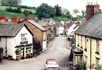
Llanrhaeadr-ym-mochnant, Llanrhaeadr-ym-mochnant, Powys
(HLCA 1009)
Small former market town around early medieval clas church, with 18th- and 19th-century stone houses, inns, shops, chapels, and former mills, huddled in narrow valley of the Afon Rhaeadr.
Historic background
The earliest settlement probably developed around the clas church at Llanrhaeadr, established by at least the 9th-century. It later became the centre of administration for the cantref of Mochnant within the kingdom of Powys. In the later 12th century the cantref was divided adminstratively along the Afon Rhaeadr, splitting the village and dividing the ecclesiastical parish into two. The division was to be followed by the later county boundaries, the north bank of the river falling within Denbighshire and the south bank in Montgomeryshire. With the local government reorganization of 1996 the two elements of the settlement were finally reunited in the county of Powys. The Denbighshire portion of the village had become part of the Marcher lordship of Chirkland following the Edwardian conquest of Wales in the later 13th century. The right to hold a market and fairs was granted in 1284, and from this developed the tiny market focused on the open triangle near the church, though because of its relative isolation it remained only of local importance. By the mid 19th century a relatively small and compact settlement had developed particularly on the northern or Denbighshire side of Afon Rhaeadr, by which time corn mills, several inns, shops, chapels, and a market hall had been erected.
Key historic landscape characteristics
Flat and narrow valley bottom, banks of river, and lower steep slopes along valley sides, between about 130-80m OD.
'The village, though not large, has an urban air'. The existing buildings, including much of the fabric of the medieval church, is predominantly of late 18th- to 19th-century date, including terraced cottages, shops, inn, chapels, vicarage. Large and imposing late 19th-century houses of locally-quarried slate with sandstone dressings, with drives and gates on south-facing slopes along the turnpike road to Pistyll Rhaeadr. Mid to late 20th-century houses and housing estates on south-east of earlier, medieval core. Some former shop-fronts redecorated for filming in the 1990s.
Communications were considerably enhanced during the second half of the 18th-century when turnpike roads were built from Llangedwyn and across the hills from Oswestry, with former toll-booths in the village. Stone bridge of 1770 across the Afon Rhaeadr replacing one washed away in a flood.
Sources
Evans 1986Hancock 1871; 1872; 1873; 1875
For further information please contact the Clwyd-Powys Archaeological Trust at this address, or link to the Countryside Council for Wales' web site at www.ccw.gov.uk.
Privacy and cookies