Cymraeg / English

|
Tanat Valley Historic Landscape |

|
Character area map |
Historic Landscape Characterisation
The Tanat Valley:
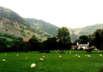
Cwm Pannant, Llangynog, Powys
(HLCA 1011)
Remote and isolated, deeply glaciated valley with clustered small farms with small enclosed fields on lower slopes and valley bottom, medieval church and legendary associations with St Melangell, abandoned farms.
Historic background
The area fell within the upper portion of the medieval ecclesiastical parish of Pennant Melangell, and fell administratively within the ancient commote of Mochnant Uwch Rhaeadr. The medieval church at Pennant Melangell, towards the head of the valley, is first recorded in the mid thirteenth century but is possibly on a Christian site established by about the 8th century on the basis of the legendary associations with Melangell. Archaeological excavations have shown that the church overlies a middle Bronze Age cremation cemetery, dating the period about 1200 BC, which suggests some form of continuity from or reuse of a pre-existing pagan burial ground. As yet, there is no clear evidence of whether the medieval church lay at the focus of a nucleated settlement or whether it was isolated in the landscape. The church had become an important centre for pilgrims visiting the shrine of Melangell from the 12th century, until the suppression of the cult at the time of the Reformation, in the mid 16th century.
Key historic landscape characteristics
Deep, glaciated Cwm Pennant, valley of the Afon Tanat, together with the even narrower Cwm Llęch, valley of the Afon Goch each with precipitous sides and each terminating in a waterfall, the valley floor lying between about 180-220m OD. The floor of each valley is about 300-400m across, yet up to about 300m below the tops of the surrounding hills, which has the effect of isolating them from each other and from the rest of the world. The enclosed land is predominantly either flat and poorly drained land on the valley-bottom or generally better-drained, sloping and steeply sloping land on the lower sides of the valley, the sides of the valleys tending to become steeper higher up. Rock outcrops and screes on sides of valleys, notably on Moel Dimoel. Rivers and streams embanked with pebbles, their beds often raised above the surrounding level. Present-day settlement comprises a number of medium-sized scattered working farms and other cottages, including a number of holiday homes. Possibly older farms appear to have been on the principal routes lower down in the valley, with later farms set in their own fields higher up. Of the farms, Graig-lâs has an 18th-century farmhouse and outbuildings, Tan-y-coed has an 18th-century stone farmhouse with remnants of earlier outbuildings, and Rhyd y Felin, Pwll Iago and Blaen-y-cwm have 18th-century stone outbuildings with modern farmhouses, the now ruinous 18th-century stone farmhouse surviving at the latter. Pengwern and Tanyfoel have late 18th to early 19th-century stone farmhouses and outbuildings. 18th-century stone cottage and attached sheds of tenement at Nant-yr-angell. Deserted 17th/18th-century farms with stone farmhouses and outbuildings at Llwyn Onn, Ty Ucha, Ty Issa Cwmllech, Nant y Gwern, Ty'n-y-cablyd. Deserted and ruinous 18th-century or earlier cottage near church and to the east of Rhyd-y-felin. Large 17th/18th-century stone house with drive and gardens at Llechwedd-y-garth. The traditional stone buildings are largely of locally-quarried slate and shale though in some instances houses and barns have foundations of rounded boulders derived from field clearance, suggesting that some may once have been cruck-built or timber-framed buildings, subsequently converted to stone. Barns with weatherboarding at Pwll Iago and Tanyfoel. Elements of late medieval cruck-framed houses have been recorded at Trefechan and Ty'n-y-cablyd, and there was once a timber-framed house at Ty Ucha, rebuilt in stone with a datestone of 1665. Occasional holiday caravans.
Land-use now predominantly pasture, but there are numerous deep lynchets especially on the sloping fields on the sides of the valley which indicating that ploughing for arable was much more widely practiced in the past. Small fields with boundaries tending to be either up and down the slope (sometimes alongside fast-flowing streams) or set out along the contour, with some older curving and irregular boundaries indicate a sequence of early, probably medieval enclosure in some areas. Field names, patterns and 19th-century ownership patterns suggest areas of relict medieval open field in several areas, including a distinctive pattern of strip fields to the south of Pwll Iago. Elsewhere, the present-day field pattern is probably of 16th to 18th-century in date. Fields on valley sides generally have stony clearance banks up to about 1m high, with mixed-species hedges including birch, oak, maple, ash and hawthorn. Roadside hedges are low cut, other hedges generally overgrown. Many hedges were formerly laid and a few have been laid recently. Damp, low-lying reedy valley-bottom meadows characteristically with overgrown willow or alder hedges. Occasional dilapidated drystone walls along lower field boundaries or alongside roads or tracks. Traces of early boundaries made of upright slate slabs near Ty Ucha. Taller alders and alder groves lining watercourses. Small areas of semi-natural oak and birch woodland on some steeper slopes. Small conifer plantations on higher slopes, with more extensive coniferous forestry on the hilltops above. Extensive area of abandoned fields on the south-facing hillside above Llechwedd-y-garth, included in the Hafod Hir character area.
The modern winding roads follow ancient tracks running in hollow-ways here and there. Modern road bridges across rivers and culvets for streams though in some instances these appear to have more ancient abutments, the name of Pont Pren Fain indicating a former narrow wooden bridge.
The farm name Rhyd-y-felin indicates a former mill, of which there is no surviving evidence.
The valley is associated in legend with Melangell, the patron saint of Pennant church, whose legend, possibly based on medieval oral tradition, but first known from a late 16th-century text, alludes to its remoteness from the world. Like Cwm Blowty, the valley is also associated with the exploits of the giant known as Cawr Berwyn, especially the prominent rocky hill known as Moel Dimoel on the southern side of the valley.
Sources
Britnell 1994a; 1994bEvans 1994
Hancock 1877; 1878; 1879
Lloyd 1934
Pryce 1994
Richards 1934a; 1934b
Silvester 1992
For further information please contact the Clwyd-Powys Archaeological Trust at this address, or link to the Countryside Council for Wales' web site at www.ccw.gov.uk.
Privacy and cookies