Cymraeg / English

|
Tanat Valley Historic Landscape |

|
Character area map |
Historic Landscape Characterisation
Dyffryn Tanat / The Tanat Valley:
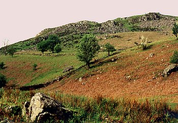
Cwm Ffynnon, Llanrhaeadr-ym-mochnant, Powys
(HLCA 1022)
19th-century enclosure and improvement of upland common on southern edge of the Berwyns
Historic background
Evidence of possible early Bronze Age activity is represented by fragments of pottery from an area overlooking the Nant y Llyn stream near the head of Cwm Blowty. The area fell within the ecclesiastical parish of Llanrhaeadr-ym-mochnant, Denbighshire and also fell within the ancient commote of Mochnant Is Rhaeadr.
Key historic landscape characteristics
Broken upland area north of Cwm Blowty, on the southern edge of the Berwyns between a height of about 330-630m OD, with sloping and steeply sloping predominantly south-facing slopes.
Areas of unimproved and improved upland grazing with, gorse, heather, shrubs and trees on steeper unimproved slopes. Field boundaries partly of post and wire but with a grid of drystone, field-clearance walls in parts of the western side of the area overlooking Cwm Blowty. Conifer plantation on eastern side of Cwm Ffynnon.
For further information please contact the Clwyd-Powys Archaeological Trust at this address, or link to the Countryside Council for Wales' web site at www.ccw.gov.uk.
Privacy and cookies